Welcome to Isla Los Brazos, a Tropical island in the North Pacific Ocean, part of the majestic Pacific Ocean. This guide offers a comprehensive overview of what makes Isla Los Brazos unique – from its geography and climate to its population, infrastructure, and beyond. Dive into the details:
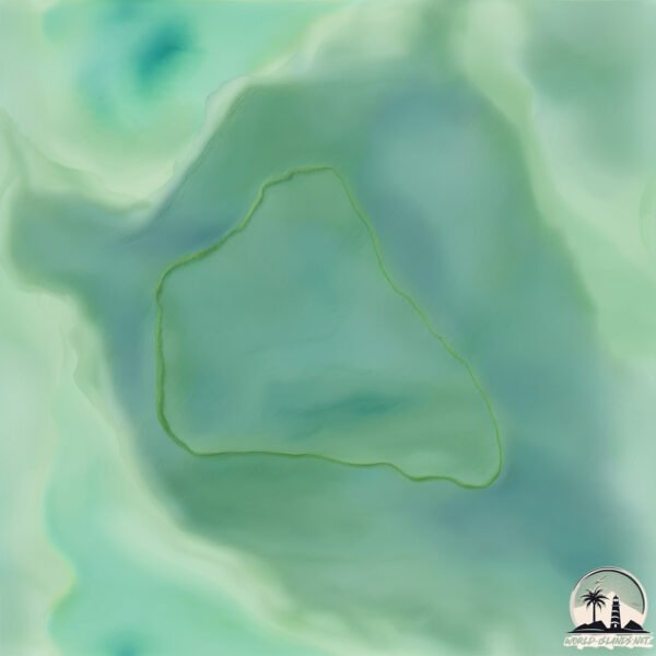
Geography and size of Isla Los Brazos
Size: 1.011 km²
Coastline: 4.1 km
Ocean: Pacific Ocean
Sea: North Pacific Ocean
Continent: South America
Isla Los Brazos is a Small Island spanning 1 km² with a coastline of 4.1 km.
Archipel: –
Tectonic Plate: North Andes – Located in South America, covering Colombia, Ecuador, and part of Venezuela, it is known for its seismic activity due to interactions with the South American Plate.
The geographic heart of the island is pinpointed at these coordinates:
Latitude: 2.87846621 / Longitude: -77.63506834
Climate and weather of Isla Los Brazos
Climate Zone: Tropical
Climate Details: Tropical Rainforest Climate
Temperature: Hot
Climate Characteristics: This climate is typified by heavy rainfall throughout the year, high humidity, and consistently high temperatures, leading to lush rainforests and rich biodiversity. Seasonal temperature variations are minimal.
Topography and nature of Isla Los Brazos
Timezone: UTC-05:00
Timezone places: America/New_York
Max. Elevation: 8 m
Mean Elevation: 6 m
Vegetation: Evergreen Broadleaf Forest
Tree Coverage: 56%
The mean elevation is 6 m. The highest elevation on the island reaches approximately 8 meters above sea level. The island is characterized by Plains: Flat, low-lying lands characterized by a maximum elevation of up to 200 meters. On islands, plains are typically coastal lowlands or central flat areas.
Dominating Vegetation: Evergreen Broadleaf Forest
Characterized by dense, lush canopies of broadleaf trees that retain their leaves year-round. These forests are typically found in tropical and subtropical regions and are known for their high biodiversity. Isla Los Brazos has a tree cover of 56 %.
Vegetation: 4 vegetation zones – Diverse Island
Four distinct vegetation zones mark these islands as ecologically diverse. They might feature varied landscapes such as forests, beaches, grasslands, and rocky areas. Such diversity reflects the island’s complex ecological interactions and varied habitats, which can support a rich array of wildlife and plant species.
Infrastructure and Travelling to Isla Los Brazos
Does the island have a public airport? no.
There is no public and scheduled airport on Isla Los Brazos. The nearest airport is Juan Casiano Airport, located 44 km away.
Does the island have a major port? no.
There are no major ports on Isla Los Brazos. The closest major port is BUENAVENTURA, approximately 128 km away.
The mean population of Isla Los Brazos is 9 per km². Isla Los Brazos is Gently Populated. The island belongs to Colombia.
Continuing your journey, Soledad is the next notable island, situated merely km away.
En Mis Brazos - Reunión | Letra | Barbie™ como "La Princesa de la Isla"
Disfruta de tus letras favoritas de Barbie™ como "La Princesa de la Isla" Mira más letras de Barbie™ como "La Princesa de la ...En Mis Brazos - Reunión | Letra | Barbie™ como "La Princesa de la Isla"
Disfruta de tus letras favoritas de Barbie™ como "La Princesa de la ...
Disfruta de tus letras favoritas de Barbie™ como "La Princesa de la Isla" Mira más letras de Barbie™ como "La Princesa de la ...
En Mis Brazos | Vídeo Musical | Barbie™ como "La Princesa de la Isla"
Escucha junto a Tika la canción que Ro (Rosella) canta como una ...
Escucha junto a Tika la canción que Ro (Rosella) canta como una canción de cuna! ¡Tú también puedes cantarla! Mira más ...
"En mis brazos estas" (Letra) "Barbie" la princesa de la isla - canción para dormir
"En mis brazos estas" (Letra) cancion para dormir Rosela Se va el sol ...
"En mis brazos estas" (Letra) cancion para dormir Rosela Se va el sol y todo se embellece Con su luz nos van a iluminar Mamá ...
En Mis Brazos - Reunión | Vídeo Musical | Barbie™ como "La Princesa de la Isla"
Vuelve a cantar la canción completa junta a Rosella y su Madre! Mira ...
Vuelve a cantar la canción completa junta a Rosella y su Madre! Mira más videos de Barbie como "La Princesa de la Isla": ...
Debo Saber | Letra | Barbie™ como "La Princesa de la Isla"
Disfruta de tus letras favoritas de Barbie™ como "La Princesa de la ...
Disfruta de tus letras favoritas de Barbie™ como "La Princesa de la Isla" Mira más letras de Barbie™ como "La Princesa de la ...
JIMIN corriendo a los brazos de EUNWOO 😍
ellos tienen una linda amistad y me encantan son lindos ambos ...
ellos tienen una linda amistad y me encantan son lindos ambos pertenecen a grupo diferente #jimin #eunwoo #bts #astro.
Vistas de la playa Sairee en Koh Tao en Mango View Point
Día 149/365 haciendo una flexion de brazos más por cada día del año, ...
Día 149/365 haciendo una flexion de brazos más por cada día del año, con mi perro Diego!
En Mis Brazos (REUNION) (Letra) - Barbie en la Princesa de la Isla #barbie
✨¿Cómo encontrar la ISLA KITZUNE fácil y rápido? 🤑| #roblox #bloxfruits #kitzune #RobloxBloxfruits
Manera sencilla y con mucha suerte, conseguirás tu fruta kitzune en ...
Manera sencilla y con mucha suerte, conseguirás tu fruta kitzune en blox fruits en roblox.
SOUTH PADRE ISLAND, TEXAS: Top Things to Do, SPI Attractions, Best Places to Visit Travel Guide
In this video, we'll see top things to do and best places to visit in ...
In this video, we'll see top things to do and best places to visit in South Padre Island, Texas. South Padre Island Live Cam, SPI, ...
Todos creían que era una isla
My first impressions of the island of Anguilla
My first impressions of Anguilla? Pure magic. Crystal-clear waters, ...
My first impressions of Anguilla? Pure magic. Crystal-clear waters, powdery white sand, and the friendliest people you'll ever meet ...
TODOS los FINALES de SONS of the FOREST 🌲😱 ¡Ojo SPOILERS! ⚠ #sonsoftheforest
Estos son todos los finales de Sons of the Forest #videojuegos #juegos ...
Estos son todos los finales de Sons of the Forest #videojuegos #juegos #vandal #gaming #gamingespañol ...
#Barbie - En Mis Brazos (ISLA) (Letra) | Barbie en la Princesa de la Isla
⚠️" Estos titanes aún siguen durmiendo" ⚠️ #short #100k #titanes
Los jefes más difíciles de BB racing #bbracing #edit #shorts
accidente de juego mecánico
Each Uisge va a M4TARTE #Shorts
Animación sobre una mítica leyenda escosesa, Each Uisge, un espíritu ...
Animación sobre una mítica leyenda escosesa, Each Uisge, un espíritu malévolo que distraía a personas en las aguas para que ...
#shortsyoutube DESCUBRE 😱EL PARAISO GALLEGO, UN LUGAR LLENO DE LUGARES EXPECTACULARES VISTAS #reels
Isla de Arousa: Descubre la Joya Oculta de Galicia La Isla de Arousa ...
Isla de Arousa: Descubre la Joya Oculta de Galicia La Isla de Arousa es un tesoro escondido en la costa gallega, conocida por ...
#babifreitas
Nunca has visto un accidente como este. Un avión de pasajeros de Delta ...
Nunca has visto un accidente como este. Un avión de pasajeros de Delta Air Lines, que viajaba desde Minneapolis a Toronto, ...
🤑ISLA te PAGA por vivir #datoscuriosos#sabiasque #curiosidades #viajes #dinero #guernsey
Te imaginas vivir en un lugar donde te paguen por hacerlo? En este ...
Te imaginas vivir en un lugar donde te paguen por hacerlo? En este fascinante video, exploraremos países y ciudades que ...
Peores Torturas Que Tú Puedes Experimentar
¡¡¡LA UNICA DERROTA DE ISLAM MAKHACHEV!!! 💀🤯|#ufc #mma #viral #islammakhachev
Así nació el D-Rex #jurassicworld #humor #dinosaurios #godzilla #jurassicworldrebirth #shorts
🌴 Army Soldier Rescues Dozens After Pier Collapse at Island Resort
Army Soldier Rescues Dozens After Pier Collapse at Island Resort On a ...
Army Soldier Rescues Dozens After Pier Collapse at Island Resort On a sunlit island resort, a soldier sat quietly at a boardwalk ...
Colombia is classified as Developing region: Regions characterized by lower income levels, with economies in the process of industrialization and modernization. The level of income is Upper middle income.
News – Latest Updates and Headlines from Isla Los Brazos
Stay informed with the most recent news and important headlines from Isla Los Brazos. Here’s a roundup of the latest developments.
Loading...
Please note: The data used here has been primarily extracted from satellite readings. Deviations from exact values may occur, particularly regarding the height of elevations and population density. Land area and coastline measurements refer to average values at mean high tide.