Isla Morton
Welcome to Isla Morton, a Temperate island in the South Pacific Ocean, part of the majestic Pacific Ocean. This guide offers a comprehensive overview of what makes Isla Morton unique – from its geography and climate to its population, infrastructure, and beyond. Dive into the details:
- Geography and Size: Explore the island’s size and location.
- Climate and Weather: Weather patterns and temperature.
- Topography and Nature: Uncover the natural wonders of the island.
- Infrastructure and Travelling: Insights on reaching, staying, and making the most of your visit.
- News and Headlines: Latest News.
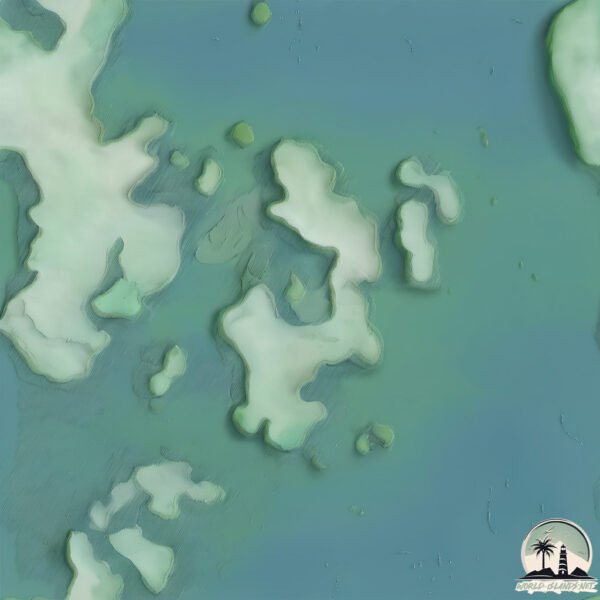
Geography and size of Isla Morton
Size: 1.04 km²
Coastline: 9.8 km
Ocean: Pacific Ocean
Sea: South Pacific Ocean
Continent: South America
Isla Morton is a Small Island spanning 1 km² with a coastline of 9.8 km.
Archipel: –
Tectonic Plate: South America – A major plate covering the South American continent and part of the Atlantic Ocean, known for the Andes mountain range and significant seismic and volcanic activity.
The geographic heart of the island is pinpointed at these coordinates:
Latitude: -49.12357327 / Longitude: -74.38956226
Climate and weather of Isla Morton
Climate Zone: Temperate
Climate Details: Subpolar Oceanic Climate
Temperature: Cold Summer
Climate Characteristics: Predominantly cold with cool summers and no dry season. Often found in coastal areas at higher latitudes or on islands.
Topography and nature of Isla Morton
Timezone: UTC-04:00
Timezone places: America/La_Paz
Max. Elevation: 4 m
Mean Elevation: -6 m
Vegetation: Open Woodland
Tree Coverage: 96%
The mean elevation is -6 m. The highest elevation on the island reaches approximately 4 meters above sea level. The island is characterized by Plains: Flat, low-lying lands characterized by a maximum elevation of up to 200 meters. On islands, plains are typically coastal lowlands or central flat areas.
Dominating Vegetation: Open Woodland
Characterized by sparsely distributed trees with open canopy allowing sunlight to penetrate, supporting grasses and shrubs underneath. Often found in drier or transitional environments. Isla Morton has a tree cover of 96 %.
Vegetation: 3 vegetation zones – Moderately Diverse Island
These islands start to show a broader range of ecological niches. With three vegetation zones, they may offer a mix of ecosystems like coastal areas, inland woods, and perhaps a distinct wetland or dry area. This diversity supports a wider range of flora and fauna, making these islands more ecologically complex than those with minimal diversity.
Infrastructure and Travelling to Isla Morton
Does the island have a public airport? no.
There is no public and scheduled airport on Isla Morton. The nearest airport is El Calafate – Commander Armando Tola International Airport, located 289 km away.
Does the island have a major port? no.
There are no major ports on Isla Morton. The closest major port is PUERTO NATALES, approximately 351 km away.
The mean population of Isla Morton is 1 per km². Isla Morton is Uninhabited. The island belongs to Chile.
Continuing your journey, Saumarez is the next notable island, situated merely km away.
10 reasons to NEVER visit Moreton Island


Chile is classified as Emerging region: G20: Group of Twenty – Major economies comprising both developed and emerging countries, representing the world’s largest economies. The level of income is Upper middle income.
News – Latest Updates and Headlines from Isla Morton
Stay informed with the most recent news and important headlines from Isla Morton. Here’s a roundup of the latest developments.
Please note: The data used here has been primarily extracted from satellite readings. Deviations from exact values may occur, particularly regarding the height of elevations and population density. Land area and coastline measurements refer to average values at mean high tide.