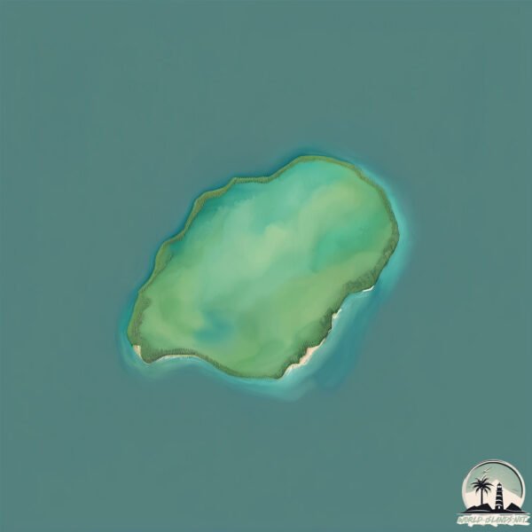
Welcome to Isla Mutri, a Temperate island in the South Pacific Ocean, part of the majestic Pacific Ocean. This guide offers a comprehensive overview of what makes Isla Mutri unique – from its geography and climate to its population, infrastructure, and beyond. Dive into the details:
Geography and size of Isla Mutri
Size: 0.219 km²
Coastline: 1.8 km
Ocean: Pacific Ocean
Sea: South Pacific Ocean
Continent: South America
Isla Mutri is a Tiny Island spanning 0.219 km² with a coastline of 1.8 km.
Archipel: –
Tectonic Plate: South America – A major plate covering the South American continent and part of the Atlantic Ocean, known for the Andes mountain range and significant seismic and volcanic activity.
The geographic heart of the island is pinpointed at these coordinates:
Latitude: -42.06843108 / Longitude: -72.61101524
Climate and weather of Isla Mutri
Climate Zone: Temperate
Climate Details: Temperate Oceanic Climate
Temperature: Warm Summer
Climate Characteristics: Known for its moderate year-round temperatures with ample rainfall and no dry season. Warm summers are characteristic.
Topography and nature of Isla Mutri
Timezone: UTC-04:00
Timezone places: America/La_Paz
Max. Elevation: -21 m
Mean Elevation: -56 m
Vegetation: Evergreen Broadleaf Forest
Tree Coverage: 91%
The mean elevation is -56 m. Remarkably, this unique island barely emerges above the sea level, showcasing nature’s fascinating interplay with the ocean. The island is characterized by Plains: Flat, low-lying lands characterized by a maximum elevation of up to 200 meters. On islands, plains are typically coastal lowlands or central flat areas.
Dominating Vegetation: Evergreen Broadleaf Forest
Characterized by dense, lush canopies of broadleaf trees that retain their leaves year-round. These forests are typically found in tropical and subtropical regions and are known for their high biodiversity. Isla Mutri has a tree cover of 91 %.
Vegetation: 1 vegetation zones – Minimal Diversity Island
These islands exhibit the most basic level of ecological diversity, often characterized by a single dominant vegetation type. This could be due to extreme environmental conditions, limited land area, or significant human impact. They represent unique ecosystems where specific species have adapted to thrive in these singular environments.
Infrastructure and Travelling to Isla Mutri
Does the island have a public airport? no.
There is no public and scheduled airport on Isla Mutri. The nearest airport is El Tepual Airport, located 88 km away.
Does the island have a major port? no.
There are no major ports on Isla Mutri. The closest major port is PUERTO MONTT, approximately 76 km away.
The mean population of Isla Mutri is 3 per km². Isla Mutri is Gently Populated. The island belongs to Chile.
Continuing your journey, Llancahue is the next notable island, situated merely km away.
The Famous Easter Island Heads Have Hidden Bodies #easterisland #rapanui #ancienthistory #ancient
The Famous Easter Island Heads Have Hidden Bodies #easterisland #rapanui #ancienthistory #ancient
The Strange Finding About The Moai Statues in Easter Island
What is EASTER ISLAND Really Like? 🇨🇱 (not what we expected)
Easter Island, Rapa Nui, Isla de Pascua - whatever you call it, this ...
Easter Island, Rapa Nui, Isla de Pascua - whatever you call it, this place is one of a kind. In this travel vlog we fly from Santiago, ...
The moai concept 💀#vairal #trending #shorts
moment before disaster troll face troll face edit #trollface ...
moment before disaster troll face troll face edit #trollface #trollfaceedit #troll #edit #meme #trending #shorts #shortsfeed ...
Human remains found buried under Easter Island statues | Unearthed | Science Channel
shorts #unearthed #sciencechannel.
shorts #unearthed #sciencechannel.
Easter Island is a great solo trip for female travelers #easterisland #solofemaletraveler #rapanui
Easter Island mystery is SOLVED
The origin of Easter Island's iconic head statues is one of the ...
The origin of Easter Island's iconic head statues is one of the world's greatest archaeological puzzles. Now, scientists claim to ...
The Mystery of Easter Island
MOAI STATUE secrets revealed 😳 ||eastern Island statue
MOAI STATUE secrets revealed ||eastern Island statue How did the ...
MOAI STATUE secrets revealed ||eastern Island statue How did the ancient people move the massive Moai statues of Easter ...
क्या हैं ये Moai मूर्तियाँ? | Easter Island का सच
आखिर क्या है इन मूर्तियों का रहस्य | Unsolved mystery | Easter Island
Easter Island, one of the most remote places on Earth, is home to ...
Easter Island, one of the most remote places on Earth, is home to nearly 900 mysterious stone statues known as Moai. Carved ...
Temple of Massa al Dajjal| Dajjal in Guffa| Dajjal Cave | Dajal | Astola Island
Created by @MuhammadAdnan3115 #Dajjal #Islamic #History.
Created by @MuhammadAdnan3115 #Dajjal #Islamic #History.
The Mysterious Easter Island
EasterIsland #Moai #AncientCivilization #Mystery In this episode, we ...
EasterIsland #Moai #AncientCivilization #Mystery In this episode, we explore the mysteries of Easter Island, a remote volcanic ...
Sigma GiGACHAD Moai statues🗿 | The MYSTERY of Easter Island
The Moai statues are mysterious and iconic stone sculptures found on ...
The Moai statues are mysterious and iconic stone sculptures found on Easter Island, also known as Rapa Nui. The Moai statues ...
Astola Island | The largest Island of Pakistan | #shorts
Astola Island, also known as Jezira Haft Talar Satadip or 'Island of ...
Astola Island, also known as Jezira Haft Talar Satadip or 'Island of the Seven Hills', is a small uninhabited Pakistani island in the ...
Hidden Secrets of Easter Island (ईस्टर आइलैंड) | Rapa Nui | Mystery | Facts in Hindi | Moai
This video is about "Hidden Secrets of Easter Island (ईस्टर आइलैंड) | ...
This video is about "Hidden Secrets of Easter Island (ईस्टर आइलैंड) | Rapa Nui | Mystery | Facts in Hindi | Moai" ...
hanga roa Island Murti Indian
आइलैंड पर बनी रहस्यमय मुर्तिया | Why So Many Statues At Easter Island #shorts
आइलैंड पर बनी रहस्यमय मुर्तिया | Why So Many Statues At Easter Island ...
आइलैंड पर बनी रहस्यमय मुर्तिया | Why So Many Statues At Easter Island #shortvideo #viralshorts ...
The Most Mysterious Island of Pakistan | Dajal was Supposed to be there #mysteriousisland
The Secret Of The Moai Statues On Easter Island
রহস্যময় মূর্তি মোয়াই ও ইস্টার আইল্যান্ড | কি কেন কিভাবে | Easter Island | Ki Keno Kivabe
সুদীর্ঘকাল ধরে গবেষকদের মনে বিষ্ময় জাগিয়ে রেখেছে আগ্নেয় দ্বীপ ...
সুদীর্ঘকাল ধরে গবেষকদের মনে বিষ্ময় জাগিয়ে রেখেছে আগ্নেয় দ্বীপ ...
Easter Island History in Hindi | SECRETS of Easter Island Statues | Rapa Nui | Ancient Polynesians
Easter Island History in Hindi | SECRETS of Easter Island Statues | ...
Easter Island History in Hindi | SECRETS of Easter Island Statues | Rapa Nui | Ancient Polynesians --------- Have you ever ...
found this in google maps a sea monster
Please Subscribe, Share and Like my channel for more google maps ...
Please Subscribe, Share and Like my channel for more google maps easter eggs Please hit the bell button for our new video ...
ইস্টার দ্বীপ সম্পর্কে বিজ্ঞানীরা যা আবিষ্কার করেছেন তা আপনি বিশ্বাস করবেন না। Easter Island
In this fascinating video, we explore the latest scientific ...
In this fascinating video, we explore the latest scientific discoveries about Easter Island that will surely surprise you. For decades ...
Chile is classified as Emerging region: G20: Group of Twenty – Major economies comprising both developed and emerging countries, representing the world’s largest economies. The level of income is Upper middle income.
News – Latest Updates and Headlines from Isla Mutri
Stay informed with the most recent news and important headlines from Isla Mutri. Here’s a roundup of the latest developments.
Loading...
Please note: The data used here has been primarily extracted from satellite readings. Deviations from exact values may occur, particularly regarding the height of elevations and population density. Land area and coastline measurements refer to average values at mean high tide.