Isla Oma
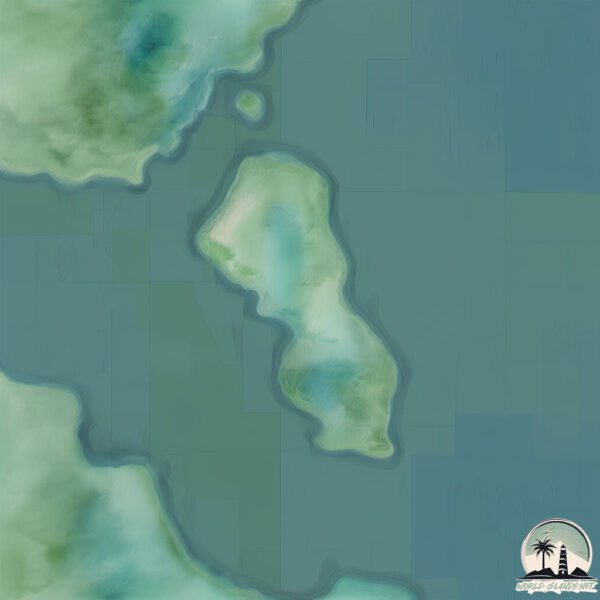
Welcome to Isla Oma, a Temperate island in the South Pacific Ocean, part of the majestic Pacific Ocean. This guide offers a comprehensive overview of what makes Isla Oma unique – from its geography and climate to its population, infrastructure, and beyond. Dive into the details:
- Geography and Size: Explore the island’s size and location.
- Climate and Weather: Weather patterns and temperature.
- Topography and Nature: Uncover the natural wonders of the island.
- Infrastructure and Travelling: Insights on reaching, staying, and making the most of your visit.
- News and Headlines: Latest News.
Geography and size of Isla Oma
Size: 2.264 km²
Coastline: 10.3 km
Ocean: Pacific Ocean
Sea: South Pacific Ocean
Continent: South America
Isla Oma is a Small Island spanning 2.3 km² with a coastline of 10.3 km.
Archipel: –
Tectonic Plate: South America – A major plate covering the South American continent and part of the Atlantic Ocean, known for the Andes mountain range and significant seismic and volcanic activity.
The geographic heart of the island is pinpointed at these coordinates:
Latitude: -46.04743137 / Longitude: -73.65565231
Climate and weather of Isla Oma
Climate Zone: Temperate
Climate Details: Subpolar Oceanic Climate
Temperature: Cold Summer
Climate Characteristics: Predominantly cold with cool summers and no dry season. Often found in coastal areas at higher latitudes or on islands.
Topography and nature of Isla Oma
Timezone: UTC-04:00
Timezone places: America/La_Paz
Max. Elevation: 63 m
Mean Elevation: 40 m
Vegetation: Evergreen Broadleaf Forest
Tree Coverage: 75%
The mean elevation is 40 m. The highest elevation on the island reaches approximately 63 meters above sea level. The island is characterized by Plains: Flat, low-lying lands characterized by a maximum elevation of up to 200 meters. On islands, plains are typically coastal lowlands or central flat areas.
Dominating Vegetation: Evergreen Broadleaf Forest
Characterized by dense, lush canopies of broadleaf trees that retain their leaves year-round. These forests are typically found in tropical and subtropical regions and are known for their high biodiversity. Isla Oma has a tree cover of 75 %.
Vegetation: 2 vegetation zones – Low Diversity Island
Islands with two distinct vegetation zones offer slightly more ecological variety. These zones could be due to differences in elevation, moisture, or other environmental factors. While still limited in biodiversity, these islands may offer a contrast between the two zones, such as a coastline with mangroves and an inland area with grassland.
Infrastructure and Travelling to Isla Oma
Does the island have a public airport? no.
There is no public and scheduled airport on Isla Oma. The nearest airport is Balmaceda Airport, located 218 km away.
Does the island have a major port? no.
There are no major ports on Isla Oma. The closest major port is PUERTO CHACABUCO, approximately 111 km away.
The mean population of Isla Oma is 1 per km². Isla Oma is Gently Populated. The island belongs to Chile.
Continuing your journey, Nalcayek is the next notable island, situated merely km away.
HOW MANY GRANDMAS ARE THERE? (Wobbly Life Secret) #gamedesign #wobblylife #wobblylifesecret


Chile is classified as Emerging region: G20: Group of Twenty – Major economies comprising both developed and emerging countries, representing the world’s largest economies. The level of income is Upper middle income.
News – Latest Updates and Headlines from Isla Oma
Stay informed with the most recent news and important headlines from Isla Oma. Here’s a roundup of the latest developments.
Please note: The data used here has been primarily extracted from satellite readings. Deviations from exact values may occur, particularly regarding the height of elevations and population density. Land area and coastline measurements refer to average values at mean high tide.