Isla Pagayo
Welcome to Isla Pagayo, a Tropical island in the North Atlantic Ocean, part of the majestic Atlantic Ocean. This guide offers a comprehensive overview of what makes Isla Pagayo unique – from its geography and climate to its population, infrastructure, and beyond. Dive into the details:
- Geography and Size: Explore the island’s size and location.
- Climate and Weather: Weather patterns and temperature.
- Topography and Nature: Uncover the natural wonders of the island.
- Infrastructure and Travelling: Insights on reaching, staying, and making the most of your visit.
- News and Headlines: Latest News.
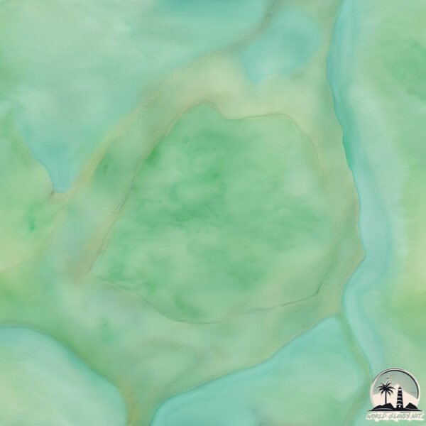
Geography and size of Isla Pagayo
Size: 11.2 km²
Coastline: 12.9 km
Ocean: Atlantic Ocean
Sea: North Atlantic Ocean
Continent: South America
Isla Pagayo is a Medium Island spanning 11 km² with a coastline of 13 km.
Archipel: –
Tectonic Plate: South America – A major plate covering the South American continent and part of the Atlantic Ocean, known for the Andes mountain range and significant seismic and volcanic activity.
The geographic heart of the island is pinpointed at these coordinates:
Latitude: 8.52616418 / Longitude: -61.00532115
Climate and weather of Isla Pagayo
Climate Zone: Tropical
Climate Details: Tropical Rainforest Climate
Temperature: Hot
Climate Characteristics: This climate is typified by heavy rainfall throughout the year, high humidity, and consistently high temperatures, leading to lush rainforests and rich biodiversity. Seasonal temperature variations are minimal.
Topography and nature of Isla Pagayo
Timezone: UTC-04:30
Timezone places: America/Caracas
Max. Elevation: 18 m
Mean Elevation: 14 m
Vegetation: Wetland
Tree Coverage: 88%
The mean elevation is 14 m. The highest elevation on the island reaches approximately 18 meters above sea level. The island is characterized by Plains: Flat, low-lying lands characterized by a maximum elevation of up to 200 meters. On islands, plains are typically coastal lowlands or central flat areas.
Dominating Vegetation: Wetland
These areas are saturated with water, either permanently or seasonally, and support aquatic plants. Wetlands are important for biodiversity and water filtration. Isla Pagayo has a tree cover of 88 %.
Vegetation: 5 vegetation zones – Highly Diverse Island
With five different vegetation zones, these islands offer a rich tapestry of ecosystems. The variety could include dense forests, open meadows, wetlands, coastal zones, and more. This level of diversity supports an intricate web of life, with each zone playing a vital role in the overall ecological health and balance of the island.
Infrastructure and Travelling to Isla Pagayo
Does the island have a public airport? no.
There is no public and scheduled airport on Isla Pagayo. The nearest airport is General Manuel Carlos Piar International Airport, located 194 km away.
Does the island have a major port? no.
There are no major ports on Isla Pagayo. The closest major port is GALEOTA POINT TERMINAL, approximately 177 km away.
The mean population of Isla Pagayo is 12 per km². Isla Pagayo is Gently Populated. The island belongs to Venezuela.
Continuing your journey, Isla Remolinos is the next notable island, situated merely km away.
What It’s Actually Like at the World Famous Four Seasons Papagayo


Venezuela is classified as Emerging region: G20: Group of Twenty – Major economies comprising both developed and emerging countries, representing the world’s largest economies. The level of income is Upper middle income.
News – Latest Updates and Headlines from Isla Pagayo
Stay informed with the most recent news and important headlines from Isla Pagayo. Here’s a roundup of the latest developments.
Please note: The data used here has been primarily extracted from satellite readings. Deviations from exact values may occur, particularly regarding the height of elevations and population density. Land area and coastline measurements refer to average values at mean high tide.