Welcome to Isla Tova, a Dry island in the South Atlantic Ocean, part of the majestic Atlantic Ocean. This guide offers a comprehensive overview of what makes Isla Tova unique – from its geography and climate to its population, infrastructure, and beyond. Dive into the details:
Geography and size of Isla Tova
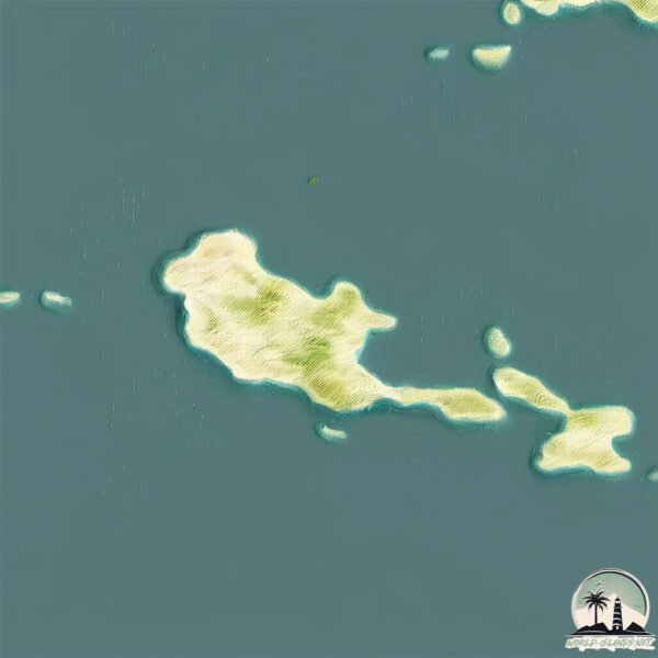
Size: 6.143 km²
Coastline: 17 km
Ocean: Atlantic Ocean
Sea: South Atlantic Ocean
Continent: South America
Isla Tova is a Small Island spanning 6.1 km² with a coastline of 17 km.
Archipel: –
Tectonic Plate: South America – A major plate covering the South American continent and part of the Atlantic Ocean, known for the Andes mountain range and significant seismic and volcanic activity.
The geographic heart of the island is pinpointed at these coordinates:
Latitude: -45.09695855 / Longitude: -65.99895247
Climate and weather of Isla Tova
Climate Zone: Dry
Climate Details: Cold Desert Climate
Temperature: Cold
Climate Characteristics: Similar in dryness to hot deserts but with cold winters. Days can be warm or hot, while nights are typically chilly with common frost occurrences.
Topography and nature of Isla Tova
Timezone: UTC-03:00
Timezone places: America/Sao_Paulo
Max. Elevation: 34 m
Mean Elevation: 15 m
Vegetation: Shrubland
Tree Coverage: 60%
The mean elevation is 15 m. The highest elevation on the island reaches approximately 34 meters above sea level. The island is characterized by Plains: Flat, low-lying lands characterized by a maximum elevation of up to 200 meters. On islands, plains are typically coastal lowlands or central flat areas.
Dominating Vegetation: Shrubland
Dominated by shrubs and small bushes, these areas are typical in dry, rocky, or sandy environments, as well as in regions with poor soil fertility. Isla Tova has a tree cover of 60 %.
Vegetation: 4 vegetation zones – Diverse Island
Four distinct vegetation zones mark these islands as ecologically diverse. They might feature varied landscapes such as forests, beaches, grasslands, and rocky areas. Such diversity reflects the island’s complex ecological interactions and varied habitats, which can support a rich array of wildlife and plant species.
Infrastructure and Travelling to Isla Tova
Does the island have a public airport? no.
There is no public and scheduled airport on Isla Tova. The nearest airport is General E. Mosconi Airport, located 178 km away.
Does the island have a major port? no.
There are no major ports on Isla Tova. The closest major port is COMODORO RIVADAVIA, approximately 182 km away.
The mean population of Isla Tova is 0 per km². Isla Tova is Uninhabited. The island belongs to Argentina.
Continuing your journey, Isla Gama is the next notable island, situated merely km away.
La isla Tovita, la isla de Chubut repleta de basura
Las islas Tova y Tovita, dentro del Parque Interjurisdiccional Marino Costero Patagonia Austral (PIMCPA), en la costa de Chubut, ...La isla Tovita, la isla de Chubut repleta de basura
Las islas Tova y Tovita, dentro del Parque Interjurisdiccional Marino ...
Las islas Tova y Tovita, dentro del Parque Interjurisdiccional Marino Costero Patagonia Austral (PIMCPA), en la costa de Chubut, ...
La isla Tovita, la isla de Chubut repleta de basura
Las islas Tova y Tovita, dentro del Parque Interjurisdiccional Marino ...
Las islas Tova y Tovita, dentro del Parque Interjurisdiccional Marino Costero Patagonia Austral (PIMCPA), en la costa de Chubut, ...
Explore Cat Island's Hidden Gem: Hiking To The Hermitage!
Embark on a journey to Cat Island's hidden gem - The Hermitage! Join ...
Embark on a journey to Cat Island's hidden gem - The Hermitage! Join us as we hike to this unique and picturesque spot on the ...
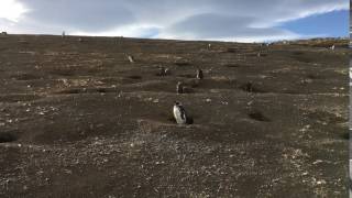
#Sociedad Nuevo streaming del CONICET, ahora con pingüinos desde la Isla Tova de Chubut.
Limpieza de las costas en la isla Tova
Isla Tenango de las Flores
Velero Alma Mía de Bahía Arredondo a Isla Tova Ep11
Navegación del Velero Alma Mía el la zona de Bahía Arredondo donde se ...
Navegación del Velero Alma Mía el la zona de Bahía Arredondo donde se muestra un antiguo asentamiento alguero en Isla ...
El Gran Hermano de los pingüinos en la Isla Tova | #LaSelva
Patagonia Azul es el programa marino de la fundación Rewilding que ...
Patagonia Azul es el programa marino de la fundación Rewilding que busca ampliar la protección del Mar Argentino.
Wing foiling! Stocking Island, Exumas Elizabeth Harbour! #sailing #sailingtova #wingfoil #bahamas
Magellanic penguins guarding their nests on Isla Magdalena
Magellanic penguins posted at the entrances of their nests at Los ...
Magellanic penguins posted at the entrances of their nests at Los Pingüinos Natural Monument on Isla Magdalena, Chile.
Hilma sailing, to Helgoland - a beautiful island! Ep 3
In this episode we are sailing from Cuxhaven to Helgoland. We're also ...
In this episode we are sailing from Cuxhaven to Helgoland. We're also having our first over night sail during this journey and ...
Blue hole fun in Andros, Bahamas.. #sailing #sailinglife #bluehole #liveaboard #diving #swimming
Isla de Toas
Maracucholario en gotas No 2 Siguenos y Activa la campanita para ...
Maracucholario en gotas No 2 Siguenos y Activa la campanita para mantenerte al tanto de nuestro contenido.
UN RESPIRO PARA EL MAR
Las islas Tova y Tovita se encuentran en el mar argentino, cerca de la ...
Las islas Tova y Tovita se encuentran en el mar argentino, cerca de la provincia de Chubut. Las diferentes corrientes marinas ...
Discover Bornholm Island: Elope in Europe
Let's explore Denmark's Bornholm Island, a stunning location that ...
Let's explore Denmark's Bornholm Island, a stunning location that exudes tranquility and adventure at the same time! Located east ...
Velero Alma Mía en Isla Leones, Patagonia
Inside Pablo Escobar's Mysterious Plane Wreck in the Bahamas
Welcome back to Sailing Tova Episode 79. We are leaving our friends in ...
Welcome back to Sailing Tova Episode 79. We are leaving our friends in Andros and headed to the Exumas. We stop for a night in ...
Velero Alma Mía de Caleta Malaspina a Isla Leones
Navegación del Velero Alma Mía de Caleta Malaspina a Isla Leones, Patagonia.
Navegación del Velero Alma Mía de Caleta Malaspina a Isla Leones, Patagonia.
PINGÜINOS entre la basura: una isla OLVIDADA en la PATAGONIA ARGENTINA
Estuvimos junto con Rewilding Argentina en la Isla Tova, una isla que ...
Estuvimos junto con Rewilding Argentina en la Isla Tova, una isla que tiene la particularida de ser contenedora de toneladas de ...
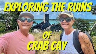
Exploring the Ruins of Crab Cay, Exuma, Bahamas. Ep.16
In this episode join us as we go spear fishing, coconut hunting, so we ...
In this episode join us as we go spear fishing, coconut hunting, so we can make sky juice, explore Crab Cay ruins and end with a ...
La Impresionante Isla de los Gatos🐈 | 2025
shorts #curiosidades INSTAGRAM ...
Isla Redonda: el secreto mejor guardado de Ushuaia | con Tolkeyen
Descubrí Isla Redonda, una de las excursiones más especiales y menos ...
Descubrí Isla Redonda, una de las excursiones más especiales y menos conocidas de Ushuaia, una experiencia que solo realiza ...
No Name Harbor: Key Biscayne's Best Kept Secret
Welcome Back to Sailing Tova Episode 73. This week see the eclipse and ...
Welcome Back to Sailing Tova Episode 73. This week see the eclipse and discover a little bit of what this beautiful island has to ...
Velero Alma Mía de Isla Leones a Caleta Sara
Navegación del Velero Alma Mía de Isla Leones a Caleta Sara, ...
Navegación del Velero Alma Mía de Isla Leones a Caleta Sara, Patagonia, Argentina.
LA ISLA DE LOS PAJAROS | FRAILECILLOS | ALCATRACES | ALCAS | ARAOS | SALTEE ISLANDS
Aventura en Irlanda para fotografiar aves marinas como frailecillos, ...
Aventura en Irlanda para fotografiar aves marinas como frailecillos, alcas, araos y alcatraces entre otras especies, intentando ...
Argentina is classified as Emerging region: G20: Group of Twenty – Major economies comprising both developed and emerging countries, representing the world’s largest economies. The level of income is Upper middle income.
News – Latest Updates and Headlines from Isla Tova
Stay informed with the most recent news and important headlines from Isla Tova. Here’s a roundup of the latest developments.
Loading...
Please note: The data used here has been primarily extracted from satellite readings. Deviations from exact values may occur, particularly regarding the height of elevations and population density. Land area and coastline measurements refer to average values at mean high tide.