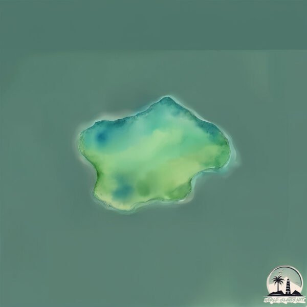
Welcome to Islote Gusano, a Temperate island in the South Pacific Ocean, part of the majestic Pacific Ocean. This guide offers a comprehensive overview of what makes Islote Gusano unique – from its geography and climate to its population, infrastructure, and beyond. Dive into the details:
Geography and size of Islote Gusano
Size: 0.109 km²
Coastline: 1.3 km
Ocean: Pacific Ocean
Sea: South Pacific Ocean
Continent: South America
Islote Gusano is a Tiny Island spanning 0.109 km² with a coastline of 1.3 km.
Archipel: –
Tectonic Plate: South America – A major plate covering the South American continent and part of the Atlantic Ocean, known for the Andes mountain range and significant seismic and volcanic activity.
The geographic heart of the island is pinpointed at these coordinates:
Latitude: -44.24516071 / Longitude: -73.2251037
Climate and weather of Islote Gusano
Climate Zone: Temperate
Climate Details: Temperate Oceanic Climate
Temperature: Warm Summer
Climate Characteristics: Known for its moderate year-round temperatures with ample rainfall and no dry season. Warm summers are characteristic.
Topography and nature of Islote Gusano
Timezone: UTC-04:00
Timezone places: America/La_Paz
Max. Elevation: 2 m
Mean Elevation: 1 m
Vegetation: Evergreen Broadleaf Forest
Tree Coverage: 92%
The mean elevation is 1 m. The highest elevation on the island reaches approximately 2 meters above sea level. The island is characterized by Plains: Flat, low-lying lands characterized by a maximum elevation of up to 200 meters. On islands, plains are typically coastal lowlands or central flat areas.
Dominating Vegetation: Evergreen Broadleaf Forest
Characterized by dense, lush canopies of broadleaf trees that retain their leaves year-round. These forests are typically found in tropical and subtropical regions and are known for their high biodiversity. Islote Gusano has a tree cover of 92 %.
Vegetation: 1 vegetation zones – Minimal Diversity Island
These islands exhibit the most basic level of ecological diversity, often characterized by a single dominant vegetation type. This could be due to extreme environmental conditions, limited land area, or significant human impact. They represent unique ecosystems where specific species have adapted to thrive in these singular environments.
Infrastructure and Travelling to Islote Gusano
Does the island have a public airport? no.
There is no public and scheduled airport on Islote Gusano. The nearest airport is Mocopulli Airport, located 218 km away.
Does the island have a major port? no.
There are no major ports on Islote Gusano. The closest major port is PUERTO CHACABUCO, approximately 142 km away.
The mean population of Islote Gusano is 0 per km². Islote Gusano is Uninhabited. The island belongs to Chile.
Continuing your journey, Atilio is the next notable island, situated merely km away.
My Singing Monsters - Dipsters Full Bodies
Hoje trago mais um vídeo para vocês de My Singing Monsters! Dicas de My Singing Monsters, Combinações My Singing ...My Singing Monsters - Dipsters Full Bodies
Hoje trago mais um vídeo para vocês de My Singing Monsters! Dicas de ...
Hoje trago mais um vídeo para vocês de My Singing Monsters! Dicas de My Singing Monsters, Combinações My Singing ...
¡ADIVINA el MONSTRUO SEGÚN su HUEVO! 🥚 #msm #mysingingmonsters #mysingmonsters #msmpokegamer #gaming
Gusanito en San Andrés (Johnny Cay) 2021 Recomendado!!! 😎🇨🇴
Tiene coste de 35000 pesos USD 10.
Tiene coste de 35000 pesos USD 10.
Museo y Taller de la Seda "Las Hilanderas" - Isla de La Palma
Desde Tolú Hasta la Isla Titipán en un Vote 2
Jugando con los chakalitos en isla social 😂🥰
Jugando con chakalitos y chakalitas en isla social en free fire ...
Jugando con chakalitos y chakalitas en isla social en free fire #freefire #shorts #freefireshorts #fyp #viral.
Jhonny Cay San Andrés Colombia Montando en el gusanito
Time Lapse - La Dragonera desde La Trapa
Vídeo acelerado de la isla de La Dragonera tomado desde La Trapa. ...
Vídeo acelerado de la isla de La Dragonera tomado desde La Trapa. Duración original 8 min. Acelerado a 1500%
Choerodon fasciatus en ACUATEC
El lábrido arlequín de colmillos (Choerodon fasciatus) es un ...
El lábrido arlequín de colmillos (Choerodon fasciatus) es un espectacular pez de vivos colores indicado para acuarios con peces ...
MAYA BAY - Un Paraíso Escondido en TAILANDIA 🇹🇭 PhiPhi island las Famosas islas Tailandesas
Una aventura de snorkel y playas paradisiacas en las que casi me ahogo ...
Una aventura de snorkel y playas paradisiacas en las que casi me ahogo felizmente nadando con peces muy chulos y ...
Rockfishing (Sargo seguimos a tope con ellos)SPINNING CANARYS ISLAND
Buenas aqui os dejo otra captura de un bonito SARGO.como siempre ...
Buenas aqui os dejo otra captura de un bonito SARGO.como siempre CAPTURA Y SUELTA.Despues de muchisimas picadas ...
Isla Arena,Parque Nacional Islas Del Rosario
Isla Arena, islas Del Rosario cartagena, Colombia. En el mar caribe. ...
Isla Arena, islas Del Rosario cartagena, Colombia. En el mar caribe. Rosario Islands in the caribean ocean south America.
Isla de Pascua:Te Pito Te Henua
Esta zona es el "ombligo del mundo" rapanui. También hay un moai ...
Esta zona es el "ombligo del mundo" rapanui. También hay un moai tumbado llamado moai Paro que es el más grande de los ...
Vacaciones en Jhonny Cay San Andrés Colombia Montando en el gusanito
La isla de las serpientes #shorts #curiosidades
La isla de las serpientes La Isla de las Cobras, ubicada frente a la ...
La isla de las serpientes La Isla de las Cobras, ubicada frente a la costa de Brasil, ha sido catalogada como el lugar más ...
⛔️🌊BUCEO en el fondo del mar en la costa de ECUADOR y me encuentro con esto😕😩
Suscríbete a mi canal de YouTube (es gratis): ...
ISLANDIA, Crystal Ice Cave Jokulsàrlòn
La maravillosa y perenne caverna de hielo en el glaciar de ...
La maravillosa y perenne caverna de hielo en el glaciar de Jokulsàrlòn, Islandia, es seguramente, la más accesible de los ...
Ictiofauna asociada a los arrecifes de coral de Los Islotes, Baja California Sur.
Esta vez fui a practicar buceo libre (freediving) al arrecife en los ...
Esta vez fui a practicar buceo libre (freediving) al arrecife en los Islotes que se encuentran en la playa “El Saltito”, ahí encontraras ...
Tour a las islas de San Bernardo
Alquiler de botes de lujos salimos de Tolú a las 8 30 AM y regreso 4 ...
Alquiler de botes de lujos salimos de Tolú a las 8 30 AM y regreso 4 00 pm comunícate al 3126265177 también tengo servicios ...
Lanchas en Tolu SUCRE Colombia
PESCANDO entre ISLOTES y ROCAS ENORMES
Un spot de PESCA increíble, precioso, y muy, MUY ROCOSO. PESCANDO ...
Un spot de PESCA increíble, precioso, y muy, MUY ROCOSO. PESCANDO ENTRE ISLOTES y ROCAS ENORMES. Consigo ...
Mud flat mailman | DW Documentary
The gulls and sandworms probably recognize Knud Knudsen, because he ...
The gulls and sandworms probably recognize Knud Knudsen, because he walks across northern Germany's mud flats every few ...
Parque Nacional Abel Tasman, Nueva Zelanda
Realizado con fotos de Google.
Realizado con fotos de Google.
The Great Barrier Reef of Australia - Underwater Life Great Barrier Coral Reef (HD)
The Great Barrier Reef of Australia Queensland beautiful great barrier ...
The Great Barrier Reef of Australia Queensland beautiful great barrier reef coverage of underwater life in the barrier reef the ...
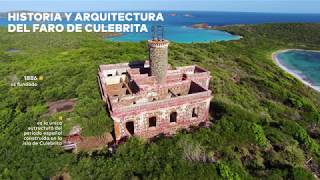
Faro de Culebrita: importancia histórica y natural (infográfica animada)
Hoy 7 de agosto se conmemora el Día Nacional de los Faros. Entérate ...
Hoy 7 de agosto se conmemora el Día Nacional de los Faros. Entérate del valor ecológico de la isla de Culebrita y el tesoro ...
Chile is classified as Emerging region: G20: Group of Twenty – Major economies comprising both developed and emerging countries, representing the world’s largest economies. The level of income is Upper middle income.
News – Latest Updates and Headlines from Islote Gusano
Stay informed with the most recent news and important headlines from Islote Gusano. Here’s a roundup of the latest developments.
Loading...
Please note: The data used here has been primarily extracted from satellite readings. Deviations from exact values may occur, particularly regarding the height of elevations and population density. Land area and coastline measurements refer to average values at mean high tide.