Jabor
Welcome to Jabor, a Tropical island in the North Pacific Ocean, part of the majestic Pacific Ocean. This guide offers a comprehensive overview of what makes Jabor unique – from its geography and climate to its population, infrastructure, and beyond. Dive into the details:
- Geography and Size: Explore the island’s size and location.
- Climate and Weather: Weather patterns and temperature.
- Topography and Nature: Uncover the natural wonders of the island.
- Infrastructure and Travelling: Insights on reaching, staying, and making the most of your visit.
- News and Headlines: Latest News.
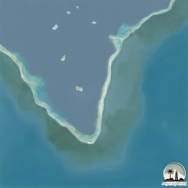
Geography and size of Jabor
Size: 3.5 km²
Coastline: 45.6 km
Ocean: Pacific Ocean
Sea: North Pacific Ocean
Continent: Oceania
Jabor is a Small Island spanning 3.5 km² with a coastline of 45.6 km.
Archipel: Micronesia – A region in the western Pacific Ocean comprising thousands of small islands, known for their unique cultures, languages, and marine ecosystems.
Tectonic Plate: Sunda – Extends across Southeast Asia, encompassing parts of the Sunda Shelf, known for its interaction with the Australian Plate, contributing to volcanic activity in Indonesia.
The geographic heart of the island is pinpointed at these coordinates:
Latitude: 5.82896186 / Longitude: 169.60891158
Climate and weather of Jabor
Climate Zone: Tropical
Climate Details: Tropical Rainforest Climate
Temperature: Hot
Climate Characteristics: This climate is typified by heavy rainfall throughout the year, high humidity, and consistently high temperatures, leading to lush rainforests and rich biodiversity. Seasonal temperature variations are minimal.
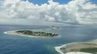
Topography and nature of Jabor
Timezone: UTC+12:00
Timezone places: Pacific/Auckland
Max. Elevation: 3 m
Mean Elevation: -6 m
Vegetation: Evergreen Needleleaf Forest
Tree Coverage: 98%
The mean elevation is -6 m. The highest elevation on the island reaches approximately 3 meters above sea level. The island is characterized by Plains: Flat, low-lying lands characterized by a maximum elevation of up to 200 meters. On islands, plains are typically coastal lowlands or central flat areas.
Dominating Vegetation: Evergreen Needleleaf Forest
Dominated by evergreen coniferous trees such as pines and firs, which retain their needle-like leaves throughout the year. These forests are often found in cooler climates. Jabor has a tree cover of 98 %.
Vegetation: 3 vegetation zones – Moderately Diverse Island
These islands start to show a broader range of ecological niches. With three vegetation zones, they may offer a mix of ecosystems like coastal areas, inland woods, and perhaps a distinct wetland or dry area. This diversity supports a wider range of flora and fauna, making these islands more ecologically complex than those with minimal diversity.
Infrastructure and Travelling to Jabor
Does the island have a public airport? yes.
Jabor has a public and scheduled airport. The following airports are located on this island: Jaluit Airport.
Does the island have a major port? no.
There are no major ports on Jabor. The closest major port is MAJURO ATOLL, approximately 232 km away.
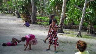
The mean population of Jabor is per km². Jabor is . The island belongs to Marshall Islands.
Continuing your journey, Majuro is the next notable island, situated merely km away.
The Marshall Islands, a nation that fears it's on the brink of extinction


Marshall Islands is classified as Developing region: Regions characterized by lower income levels, with economies in the process of industrialization and modernization. The level of income is Lower middle income.
News – Latest Updates and Headlines from Jabor
Stay informed with the most recent news and important headlines from Jabor. Here’s a roundup of the latest developments.
Please note: The data used here has been primarily extracted from satellite readings. Deviations from exact values may occur, particularly regarding the height of elevations and population density. Land area and coastline measurements refer to average values at mean high tide.