Jazīrat Abū Z̧aby
Welcome to Jazīrat Abū Z̧aby, a Dry island in the Persian Gulf, part of the majestic Indian Ocean. This guide offers a comprehensive overview of what makes Jazīrat Abū Z̧aby unique – from its geography and climate to its population, infrastructure, and beyond. Dive into the details:
- Geography and Size: Explore the island’s size and location.
- Climate and Weather: Weather patterns and temperature.
- Topography and Nature: Uncover the natural wonders of the island.
- Infrastructure and Travelling: Insights on reaching, staying, and making the most of your visit.
- News and Headlines: Latest News.
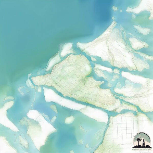
Geography and size of Jazīrat Abū Z̧aby
Size: 94.6 km²
Coastline: 126.3 km
Ocean: Indian Ocean
Sea: Persian Gulf
Continent: Asia
Jazīrat Abū Z̧aby is a Medium Island spanning 95 km² with a coastline of 126 km.
Archipel: –
Tectonic Plate: Arabia – A major tectonic plate covering the Arabian Peninsula and parts of the Middle East. The plate is primarily continental and known for its collision with the Eurasian Plate, leading to the uplift of the Zagros Mountains.
The geographic heart of the island is pinpointed at these coordinates:
Latitude: 24.45510957 / Longitude: 54.39418059
Climate and weather of Jazīrat Abū Z̧aby
Climate Zone: Dry
Climate Details: Hot Deserts Climate
Temperature: Hot
Climate Characteristics: Dominated by extremely hot temperatures, this climate is marked by minimal rainfall and barren landscapes. Nights often experience drastic temperature drops.
Topography and nature of Jazīrat Abū Z̧aby
Timezone: UTC+04:00
Timezone places: Asia/Dubai
Max. Elevation: 19 m
Mean Elevation: 5 m
Vegetation: Urban Area
Tree Coverage: 7%
The mean elevation is 5 m. The highest elevation on the island reaches approximately 19 meters above sea level. The island is characterized by Plains: Flat, low-lying lands characterized by a maximum elevation of up to 200 meters. On islands, plains are typically coastal lowlands or central flat areas.
Dominating Vegetation: Urban Area
Regions dominated by human development, including cities and towns, characterized by buildings, roads, and minimal vegetation. Jazīrat Abū Z̧aby has a tree cover of 7 %.
Vegetation: 7 vegetation zones – Very Highly Diverse Island
Islands in this range are ecological powerhouses, showcasing a wide array of vegetation zones. Each zone, from lush rainforests to arid scrublands, coastal mangroves to mountainous regions, contributes to a complex and interdependent ecosystem. These islands are often hotspots of biodiversity, supporting numerous species and intricate ecological processes.
Infrastructure and Travelling to Jazīrat Abū Z̧aby
Does the island have a public airport? no.
There is no public and scheduled airport on Jazīrat Abū Z̧aby. The nearest airport is Abu Dhabi International Airport, located 19 km away.
Does the island have a major port? no.
There are no major ports on Jazīrat Abū Z̧aby. The closest major port is UMM AN NAR, approximately 2 km away.
The mean population of Jazīrat Abū Z̧aby is 37 per km². Jazīrat Abū Z̧aby is Gently Populated. The island belongs to United Arab Emirates.
Continuing your journey, Al Ḩudayriyāt is the next notable island, situated merely km away.
Vista aérea ABU DHABI-أبو ظبي 'Abū Ẓabī


United Arab Emirates is classified as Developing region: Regions characterized by lower income levels, with economies in the process of industrialization and modernization. The level of income is High income: nonOECD.
News – Latest Updates and Headlines from Jazīrat Abū Z̧aby
Stay informed with the most recent news and important headlines from Jazīrat Abū Z̧aby. Here’s a roundup of the latest developments.
Please note: The data used here has been primarily extracted from satellite readings. Deviations from exact values may occur, particularly regarding the height of elevations and population density. Land area and coastline measurements refer to average values at mean high tide.