Welcome to Jazīrat Jabal Zuqar, a Dry island in the Red Sea, part of the majestic Indian Ocean. This guide offers a comprehensive overview of what makes Jazīrat Jabal Zuqar unique – from its geography and climate to its population, infrastructure, and beyond. Dive into the details:
Geography and size of Jazīrat Jabal Zuqar
Size: 119.8 km²
Coastline: 74.9 km
Ocean: Indian Ocean
Sea: Red Sea
Continent: Asia
Jazīrat Jabal Zuqar is a Large Island spanning 120 km² with a coastline of 75 km.
Archipel: –
Tectonic Plate: Arabia – A major tectonic plate covering the Arabian Peninsula and parts of the Middle East. The plate is primarily continental and known for its collision with the Eurasian Plate, leading to the uplift of the Zagros Mountains.
The geographic heart of the island is pinpointed at these coordinates:
Latitude: 13.99884802 / Longitude: 42.74657652
Climate and weather of Jazīrat Jabal Zuqar
Climate Zone: Dry
Climate Details: Hot Deserts Climate
Temperature: Hot
Climate Characteristics: Dominated by extremely hot temperatures, this climate is marked by minimal rainfall and barren landscapes. Nights often experience drastic temperature drops.
Topography and nature of Jazīrat Jabal Zuqar
Timezone: UTC+03:00
Timezone places: Asia/Riyadh
Max. Elevation: 500 m
Mean Elevation: 108 m
Vegetation: Rocky Terrain
Tree Coverage: 10%
The mean elevation is 108 m. The highest elevation on the island reaches approximately 500 meters above sea level. The island is characterized by Hills: Gently sloping landforms with rounded tops, having a maximum elevation between 200 and 500 meters. Hills contribute to a varied landscape on islands.
Dominating Vegetation: Rocky Terrain
Landscapes dominated by gravel, rock, and stone, with little to no vegetation. These areas are often found in mountainous regions or deserts. Jazīrat Jabal Zuqar has a tree cover of 10 %.
Vegetation: 5 vegetation zones – Highly Diverse Island
With five different vegetation zones, these islands offer a rich tapestry of ecosystems. The variety could include dense forests, open meadows, wetlands, coastal zones, and more. This level of diversity supports an intricate web of life, with each zone playing a vital role in the overall ecological health and balance of the island.
Infrastructure and Travelling to Jazīrat Jabal Zuqar
Does the island have a public airport? no.
There is no public and scheduled airport on Jazīrat Jabal Zuqar. The nearest airport is Hodeidah International Airport, located 79 km away.
Does the island have a major port? no.
There are no major ports on Jazīrat Jabal Zuqar. The closest major port is AL MUKHA, approximately 84 km away.
The mean population of Jazīrat Jabal Zuqar is 128 per km². Jazīrat Jabal Zuqar is Moderately Inhabited. The island belongs to Yemen.
Continuing your journey, Halib is the next notable island, situated merely km away.
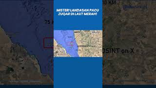
'Secret' Airstrip Near Houthi Land Uncovered Days After Mysterious Ship Attack: Red Sea War Next?
Satellite images analyzed by the Associated Press reveal the construction of a new 2000-meter airstrip on Zuqar Island in the Red ...'Secret' Airstrip Near Houthi Land Uncovered Days After Mysterious Ship Attack: Red Sea War Next?
Satellite images analyzed by the Associated Press reveal the ...
Satellite images analyzed by the Associated Press reveal the construction of a new 2000-meter airstrip on Zuqar Island in the Red ...
Airstrip on Zuqar Island Raises Concerns in Yemen Conflict | Evening Update
Reports of a new airstrip being constructed on Zuqar Island in the Red ...
Reports of a new airstrip being constructed on Zuqar Island in the Red Sea have raised concerns among experts and officials in ...
New Airstrip Rises on Yemen’s Zuqar Island near Bab el Mandeb
A new airstrip is under construction on Zuqar Island off Yemen, ...
A new airstrip is under construction on Zuqar Island off Yemen, according to fresh Planet Labs imagery analyzed by journalists.
New Airstrip Emerges on Zuqar Island – UAE-Backed Forces Expanding Anti-Houthi Operations
Royal Saudi Marines captures Zuqar island in Bab-el-Mandeb strait
Royal Saudi Marines carried out an operation to liberate Zuqar island ...
Royal Saudi Marines carried out an operation to liberate Zuqar island in Bab-el-Mandeb strait and captures weapons and some ...
Citra Satelit Ungkap Landasan Pacu 2.000 Meter di Pulau Zuqar, Strategi Anti-Houthi UAE Menguat
Citra satelit terbaru dari Planet Labs PBC yang dianalisis Associated ...
Citra satelit terbaru dari Planet Labs PBC yang dianalisis Associated Press (AP) mengungkap pembangunan landasan pacu ...
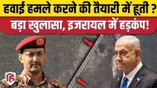
Yemen Houthi Rebels ने Red Sea के Zuqar Island पर बनाई Air Strip, Israel पर Attack की प्लानिंग ?
Yemen Houthi Rebels ने Red Sea के Zuqar Island पर बनाई Air Strip, ...
Yemen Houthi Rebels ने Red Sea के Zuqar Island पर बनाई Air Strip, Israel पर Attack की प्लानिंग ? रेड ...
Citra Satelit Ungkap Landasan Pacu 2.000 Meter di Pulau Zuqar, Strategi Anti-Houthi UAE Menguat
Citra satelit terbaru dari Planet Labs PBC yang dianalisis Associated ...
Citra satelit terbaru dari Planet Labs PBC yang dianalisis Associated Press (AP) mengungkap pembangunan landasan pacu ...
A Mysterious Airstrip Has Appeared in the Red Sea | Built by Genocidal UAE?
Satellite imagery has revealed the construction of a new airstrip on ...
Satellite imagery has revealed the construction of a new airstrip on Zuqar Island, a volcanic outcrop in the Red Sea off Yemen's ...
Houthis Going The Hezbollah Way? What Secret Airbase On Yemini Island Signals Amid Israel Tensions
The Houthis are quiet, but is it a pause or the start of the end? In ...
The Houthis are quiet, but is it a pause or the start of the end? In the Red Sea, a new runway on Zuqar Island has appeared, built ...
THE INCREDIBLE IS NEAR US...#terraemotions #SpiritOfTheLand #PeruMystery #EarthRemembers
On the western shore of Zuqar Island, among rugged cliffs and the warm ...
On the western shore of Zuqar Island, among rugged cliffs and the warm waters of the Red Sea, the terrain reveals a striking ...
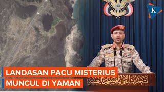
Landasan Pacu Misterius Muncul di Yaman, Dibangun Pasukan Anti-Houthi?
Sebuah landasan pacu misterius muncul di pulau vulkanik di Laut Merah, ...
Sebuah landasan pacu misterius muncul di pulau vulkanik di Laut Merah, di lepas pantai Yaman. Citra satelit yang dirilis pada ...
Hanish Islands Conflict: Battle for the Red Sea
Largely forgotten nowadays, the Hanish Islands Conflict back in the ...
Largely forgotten nowadays, the Hanish Islands Conflict back in the mid-1990s pitted a newly independent Eritrea against a ...
Citra Satelit: Landasan Udara 'Misterius' Dibangun di Laut Merah, Diduga Dilakukan oleh Anti-Houthi
Download aplikasi berita TribunX di Play Store atau App Store untuk ...
Download aplikasi berita TribunX di Play Store atau App Store untuk dapatkan pengalaman baru TRIBUN-VIDEO.COM - Citra ...
مهبط طائرات غامض في جزيرة زقر بالبحر الأحمر.. إليك أبرز التفاصيل
قناة_المهرية #اليمن #جزيرة_زقر لمتابعتنا على مدار النايلسات HD ...
قناة_المهرية #اليمن #جزيرة_زقر لمتابعتنا على مدار النايلسات HD بالترددات التالية : H 11603 معدل الترميز 27500 معامل التصحيح ...
Muncul Landasan Udara 'Rahasia' di Laut Merah, Tertangkap Citra Satelit
Download aplikasi berita TribunX di Play Store atau App Store untuk ...
Download aplikasi berita TribunX di Play Store atau App Store untuk dapatkan pengalaman baru SERAMBINEWS.COM - Citra ...
أقمار صناعية تكشف الإمارات عسكريا في جزيرة زقر وأوروبا تحذر بعد اشتعال سفينة | نشرة الأخبار
قناة_المهرية #نشرة_الأخبار || تقديم: مصطفى الفلاحي || لمتابعتنا على ...
قناة_المهرية #نشرة_الأخبار || تقديم: مصطفى الفلاحي || لمتابعتنا على مدار النايلسات HD بالترددات التالية : H 11603 معدل الترميز ...
أسوشيتدبرس تكشف عن مهبط طائرات غامض في جزيرة زقر بالبحر الأحمر يرجح استخدامه لأغراض عسكرية
قناة_المهرية #اليمن #جزيرة_زقر #خبر لمتابعتنا على مدار النايلسات HD ...
قناة_المهرية #اليمن #جزيرة_زقر #خبر لمتابعتنا على مدار النايلسات HD بالترددات التالية : H 11603 معدل الترميز 27500 معامل ...
مهبط طائرات جديد في جزيرة (زقر) اليمنية ما علاقته بالتحركات الأمريكية والإسرائيلية؟
اليمن #الإمارات #صنعاء #أمريكا #غزة #الحوثي #البحر_الأحمر #المخا ...
اليمن #الإمارات #صنعاء #أمريكا #غزة #الحوثي #البحر_الأحمر #المخا #الجزر_اليمنية #الأن #رائج_الان #أخبار #يمن_إيكو موقع إخباري ...
تعرف إلى جزيرة زقر في البحر الأحمر والوجود العسكري فيها خلال الحرب
قناة_المهرية #جزيرة_زقر #اليمن لمتابعتنا على مدار النايلسات HD ...
قناة_المهرية #جزيرة_زقر #اليمن لمتابعتنا على مدار النايلسات HD بالترددات التالية : H 11603 معدل الترميز 27500 معامل التصحيح ...
الرمعي في جزيرة زقر.. رحلة العلم الوطني
نيوزيمن.
نيوزيمن.
المقاومة_الوطنية تحبط هجوماً حوثياً بـ"مسيرة إيرانية" على جزيرة زُقر
قناة_الجمهورية #مليشيا_الحوثي #أخبار_اليمن #yemen ********** تغطية ...
قناة_الجمهورية #مليشيا_الحوثي #أخبار_اليمن #yemen ********** تغطية أخبارية متواصلة لما يجري في الجمهورية اليمنية وخارطة برامجية ...
بدعم التحالف العربي.. تدشين خفر السواحل في جزيرة زقر لتأمين الملاحة الدولية
نشرة 5 | وكالة أمريكية تكشف عن بناء الإمارات مهبط طائرات في جزيرة زُقَر اليمنية بالبحر الأحمر
وكالة أمريكية تكشف عن بناء #الإمارات مهبط طائرات في جزيرة زُقَر ...
وكالة أمريكية تكشف عن بناء #الإمارات مهبط طائرات في جزيرة زُقَر اليمنية بالبحر الأحمر ومسؤول أممي يقول إن #الحوثيين يحتجزون ممثل ...
إنشاءات عسكرية إماراتية جديدة في جزيرة زقر اليمنية
أخبار #أخبار_اليمن #اليمن_الأن #شاهد #أخبار #عاجل #المغرب #الجزائر ...
أخبار #أخبار_اليمن #اليمن_الأن #شاهد #أخبار #عاجل #المغرب #الجزائر #مصر #السعودية #العراق #اليمن #سوريا #قطر #الامارات #حصري ...
Yemen is classified as Least developed region: Countries that exhibit the lowest indicators of socioeconomic development, with the lowest Human Development Index ratings. The level of income is Lower middle income.
News – Latest Updates and Headlines from Jazīrat Jabal Zuqar
Stay informed with the most recent news and important headlines from Jazīrat Jabal Zuqar. Here’s a roundup of the latest developments.
Loading...
Please note: The data used here has been primarily extracted from satellite readings. Deviations from exact values may occur, particularly regarding the height of elevations and population density. Land area and coastline measurements refer to average values at mean high tide.