Jazīrat Shākir
Welcome to Jazīrat Shākir, a Dry island in the Gulf of Suez, part of the majestic Indian Ocean. This guide offers a comprehensive overview of what makes Jazīrat Shākir unique – from its geography and climate to its population, infrastructure, and beyond. Dive into the details:
- Geography and Size: Explore the island’s size and location.
- Climate and Weather: Weather patterns and temperature.
- Topography and Nature: Uncover the natural wonders of the island.
- Infrastructure and Travelling: Insights on reaching, staying, and making the most of your visit.
- News and Headlines: Latest News.
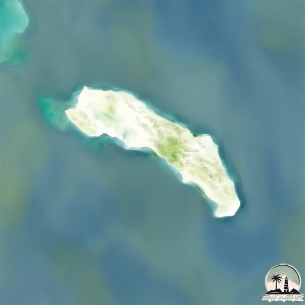
Geography and size of Jazīrat Shākir
Size: 41.6 km²
Coastline: 38.5 km
Ocean: Indian Ocean
Sea: Gulf of Suez
Continent: Africa
Jazīrat Shākir is a Medium Island spanning 42 km² with a coastline of 39 km.
Archipel: –
Tectonic Plate: Africa – One of the world’s largest tectonic plates, covering the African continent and parts of the surrounding oceans, known for its stability with some active rift zones.
The geographic heart of the island is pinpointed at these coordinates:
Latitude: 27.50059438 / Longitude: 33.98041537
Climate and weather of Jazīrat Shākir
Climate Zone: Dry
Climate Details: Hot Deserts Climate
Temperature: Hot
Climate Characteristics: Dominated by extremely hot temperatures, this climate is marked by minimal rainfall and barren landscapes. Nights often experience drastic temperature drops.
Topography and nature of Jazīrat Shākir
Timezone: UTC+02:00
Timezone places: Europe/Mariehamn
Max. Elevation: 200 m
Mean Elevation: 95 m
Vegetation: Rocky Terrain
Tree Coverage: 6%
The mean elevation is 95 m. The highest elevation on the island reaches approximately 200 meters above sea level. The island is characterized by Plains: Flat, low-lying lands characterized by a maximum elevation of up to 200 meters. On islands, plains are typically coastal lowlands or central flat areas.
Dominating Vegetation: Rocky Terrain
Landscapes dominated by gravel, rock, and stone, with little to no vegetation. These areas are often found in mountainous regions or deserts. Jazīrat Shākir has a tree cover of 6 %.
Vegetation: 7 vegetation zones – Very Highly Diverse Island
Islands in this range are ecological powerhouses, showcasing a wide array of vegetation zones. Each zone, from lush rainforests to arid scrublands, coastal mangroves to mountainous regions, contributes to a complex and interdependent ecosystem. These islands are often hotspots of biodiversity, supporting numerous species and intricate ecological processes.
Infrastructure and Travelling to Jazīrat Shākir
Does the island have a public airport? no.
There is no public and scheduled airport on Jazīrat Shākir. The nearest airport is Hurghada International Airport, located 39 km away.
Does the island have a major port? no.
There are no major ports on Jazīrat Shākir. The closest major port is EL GHARDAQA, approximately 32 km away.
The mean population of Jazīrat Shākir is 0 per km². Jazīrat Shākir is Uninhabited. The island belongs to Saudi Arabia.
Continuing your journey, Jazīrat Ţawīlah is the next notable island, situated merely km away.
Saudi Arabia is classified as Emerging region: G20: Group of Twenty – Major economies comprising both developed and emerging countries, representing the world’s largest economies. The level of income is Lower middle income.
News – Latest Updates and Headlines from Jazīrat Shākir
Stay informed with the most recent news and important headlines from Jazīrat Shākir. Here’s a roundup of the latest developments.
Please note: The data used here has been primarily extracted from satellite readings. Deviations from exact values may occur, particularly regarding the height of elevations and population density. Land area and coastline measurements refer to average values at mean high tide.