Jazīrat Zabarjad
Welcome to Jazīrat Zabarjad, a Dry island in the Red Sea, part of the majestic Indian Ocean. This guide offers a comprehensive overview of what makes Jazīrat Zabarjad unique – from its geography and climate to its population, infrastructure, and beyond. Dive into the details:
- Geography and Size: Explore the island’s size and location.
- Climate and Weather: Weather patterns and temperature.
- Topography and Nature: Uncover the natural wonders of the island.
- Infrastructure and Travelling: Insights on reaching, staying, and making the most of your visit.
- News and Headlines: Latest News.
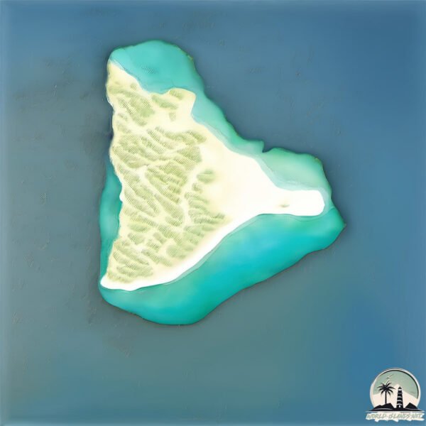
Geography and size of Jazīrat Zabarjad
Size: 2.156 km²
Coastline: 10.5 km
Ocean: Indian Ocean
Sea: Red Sea
Continent: Africa
Jazīrat Zabarjad is a Small Island spanning 2.2 km² with a coastline of 10.5 km.
Archipel: –
Tectonic Plate: India – A major tectonic plate that initially moved northward at a rapid pace before colliding with the Eurasian Plate. This collision is responsible for the uplift of the Himalayas and the Tibetan Plateau.
The geographic heart of the island is pinpointed at these coordinates:
Latitude: 23.60658131 / Longitude: 36.19980818
Climate and weather of Jazīrat Zabarjad
Climate Zone: Dry
Climate Details: Hot Deserts Climate
Temperature: Hot
Climate Characteristics: Dominated by extremely hot temperatures, this climate is marked by minimal rainfall and barren landscapes. Nights often experience drastic temperature drops.
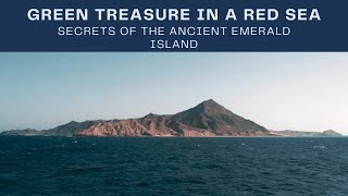
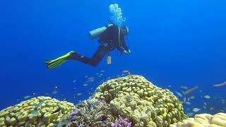
Topography and nature of Jazīrat Zabarjad
Timezone: UTC+02:00
Timezone places: Europe/Mariehamn
Max. Elevation: -1 m
Mean Elevation: -23 m
Vegetation: Sparse Vegetation
Tree Coverage: 64%
The mean elevation is -23 m. Remarkably, this unique island barely emerges above the sea level, showcasing nature’s fascinating interplay with the ocean. The island is characterized by Plains: Flat, low-lying lands characterized by a maximum elevation of up to 200 meters. On islands, plains are typically coastal lowlands or central flat areas.
Dominating Vegetation: Sparse Vegetation
These regions have limited plant growth, typically due to extreme conditions like aridity or poor soils. Vegetation is scattered and consists of hardy plant species. Jazīrat Zabarjad has a tree cover of 64 %.
Vegetation: 3 vegetation zones – Moderately Diverse Island
These islands start to show a broader range of ecological niches. With three vegetation zones, they may offer a mix of ecosystems like coastal areas, inland woods, and perhaps a distinct wetland or dry area. This diversity supports a wider range of flora and fauna, making these islands more ecologically complex than those with minimal diversity.
Infrastructure and Travelling to Jazīrat Zabarjad
Does the island have a public airport? no.
There is no public and scheduled airport on Jazīrat Zabarjad. The nearest airport is Yanbu Airport / Prince Abdul Mohsin bin Abdulaziz international Airport, located 214 km away.
Does the island have a major port? no.
There are no major ports on Jazīrat Zabarjad. The closest major port is YANBU, approximately 211 km away.
The mean population of Jazīrat Zabarjad is 0 per km². Jazīrat Zabarjad is Uninhabited. The island belongs to Egypt.
Continuing your journey, Al Hasani is the next notable island, situated merely km away.
Zabargad Island Red Sea Egypt


Egypt is classified as Emerging region: G20: Group of Twenty – Major economies comprising both developed and emerging countries, representing the world’s largest economies. The level of income is Lower middle income.
News – Latest Updates and Headlines from Jazīrat Zabarjad
Stay informed with the most recent news and important headlines from Jazīrat Zabarjad. Here’s a roundup of the latest developments.
Please note: The data used here has been primarily extracted from satellite readings. Deviations from exact values may occur, particularly regarding the height of elevations and population density. Land area and coastline measurements refer to average values at mean high tide.