Welcome to Jerba, a Dry island in the Mediterranean Sea – Eastern Basin, part of the majestic Atlantic Ocean. This guide offers a comprehensive overview of what makes Jerba unique – from its geography and climate to its population, infrastructure, and beyond. Dive into the details:
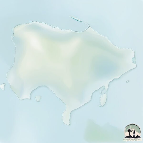
Geography and size of Jerba
Size: 510.3 km²
Coastline: 161.1 km
Ocean: Atlantic Ocean
Sea: Mediterranean Sea – Eastern Basin
Continent: Africa
Jerba is a Large Island spanning 510 km² with a coastline of 161 km.
Archipel: –
Tectonic Plate: Africa – One of the world’s largest tectonic plates, covering the African continent and parts of the surrounding oceans, known for its stability with some active rift zones.
The geographic heart of the island is pinpointed at these coordinates:
Latitude: 33.79303645 / Longitude: 10.87954396
Climate and weather of Jerba
Climate Zone: Dry
Climate Details: Hot Deserts Climate
Temperature: Hot
Climate Characteristics: Dominated by extremely hot temperatures, this climate is marked by minimal rainfall and barren landscapes. Nights often experience drastic temperature drops.
Topography and nature of Jerba
Timezone: UTC+01:00
Timezone places: Europe/Paris
Max. Elevation: 45 m
Mean Elevation: 13 m
Vegetation: Sparse Vegetation
Tree Coverage: 7%
The mean elevation is 13 m. The highest elevation on the island reaches approximately 45 meters above sea level. The island is characterized by Plains: Flat, low-lying lands characterized by a maximum elevation of up to 200 meters. On islands, plains are typically coastal lowlands or central flat areas.
Dominating Vegetation: Sparse Vegetation
These regions have limited plant growth, typically due to extreme conditions like aridity or poor soils. Vegetation is scattered and consists of hardy plant species. Jerba has a tree cover of 7 %.
Vegetation: 13 vegetation zones – Exceptionally Diverse Island
Islands with more than ten vegetation zones are among the most ecologically rich and varied in the world. These islands are akin to miniature continents, boasting an incredible array of ecosystems. The sheer range of habitats, from high peaks to deep valleys, rainforests to deserts, creates a mosaic of life that is unparalleled. They are crucial for conservation and ecological studies.
Infrastructure and Travelling to Jerba
Does the island have a public airport? yes.
Jerba has a public and scheduled airport. The following airports are located on this island: Djerba Zarzis International Airport.
Does the island have a major port? yes.
Jerba is home to a major port. The following ports are situated on the island: HOUMT SOUK.
The mean population of Jerba is 353 per km². Jerba is Moderately Inhabited. The island belongs to Tunisia.
Continuing your journey, Melitta is the next notable island, situated merely km away.
What to see on Djerba island | TRAVEL
SUBSCRIBE: https://youtube.com/@TRVL-teller Have you heard of Djerba Island in Tunisia? Ever wondered what to see there, ...What to see on Djerba island | TRAVEL
Discovering Djerba: A Unique Island Settlement in Tunisia
Explore the captivating island of Djerba in Tunisia, a remarkable ...
Explore the captivating island of Djerba in Tunisia, a remarkable testament to unique settlement patterns. In this 10-minute journey ...
Djerba, Tunisia Island of Dreams & Living History
Off Tunisia's southeastern coast lies Djerba—an island where ...
Off Tunisia's southeastern coast lies Djerba—an island where whitewashed homes, blue waters, and ancient cultures come ...
🌴 Djerba Island Paradise | Stunning Panoramic Beach - Dar Jerba Narjess Hotel
Discover the breathtaking beauty of Djerba Island in Tunisia! ✨ Enjoy ...
Discover the breathtaking beauty of Djerba Island in Tunisia! ✨ Enjoy panoramic views of the front beach at Dar Djerba ...
Djerba Day 1 Disaster | What Nobody Tells You Before Visiting | Tunisia
Djerba #TunisiaTravel In this video, I share exactly what went wrong ...
Djerba #TunisiaTravel In this video, I share exactly what went wrong on my first day in Djerba Island — from travel mistakes to ...
NEW DESTINATION 🚨 Introducing Djerba Island in Tunisia 🇹🇳 #djerba #tunisia
Discover Djerba Island:
https://cli.re/AYyE1N Booking from November 2024, flights from Manchester and Luton airport.
🇹🇳 What are the BEST HOTELS in DJERBA Tunisia 2024 ? (All inclusive Hotels Review)
What is the best hotel in Djerba ? And where to stay in Djerba ? This ...
What is the best hotel in Djerba ? And where to stay in Djerba ? This is our TOP 5 of the best hotels in Djerba ! After several trips ...in ...[+] Show More The Hidden Paradise of Djerba 🌴 Tunisia’s Most Beautiful Island Top things to see in Djerba,Tunisia
Discover Paradise Island in Djerba + Epic Pirate Boat Ride! ☠️ Join ...
Discover Paradise Island in Djerba + Epic Pirate Boat Ride! ☠️ Join us on an unforgettable adventure to Paradise Island in ...
Djerba, Tunisia - 20 Things to Do in 4 days - Djerba Travel Guide
Djerba, Tunisia - 20 Things to Do in 4 days - Djerba Travel Guide ...
Djerba, Tunisia - 20 Things to Do in 4 days - Djerba Travel Guide Discover Djerba, Tunisia's enchanting "Island of Dreams," with ...
Experience the BEST of Tunisia's HIDDEN GEM Djerba Island!
Discover the enchanting Djerba Island, famed for its stunning beaches ...
Discover the enchanting Djerba Island, famed for its stunning beaches and traditional Berber villages. Journey with us to one of ...
Best Things To Do in Djerba | Tunisia Travel Guide (Episode 2)
Djerba is a beautiful island located off the coast of Tunisia, known ...
Djerba is a beautiful island located off the coast of Tunisia, known for its stunning beaches, historic landmarks, and vibrant culture.
Djerba, Tunisia: 20 Epic Things to Do in Djerba, Tunisia 💕
empowerment #travel #djerba_tunisia Djerba, Tunisia: 20 Epic Things to ...
empowerment #travel #djerba_tunisia Djerba, Tunisia: 20 Epic Things to Do in Djerba, Tunisia Djerba Unveiled: 20 Epic ...
Top 10 Best All-Inclusive Resorts & Hotels in Djerba , Tunisia
Top 10 Best All-Inclusive Resorts & Hotels in Djerba , Tunisia Welcome ...
Top 10 Best All-Inclusive Resorts & Hotels in Djerba , Tunisia Welcome to the enchanting island of Djerba, Tunisia, where ...
Djerba 4K - Tunisia Summer
So after 4 months i decide to make a short video compilation form last ...
So after 4 months i decide to make a short video compilation form last summer trip to Djerba it was just 4 days journey to shoot a ...
Inside One of the LAST Arab Jewish Communities in the World | Tunisia 🇹🇳 جربة
11 must do’s & see in djerba, Tunisia 🇹🇳 #tunisia #djerba #djerbahood #lifeofapassion #travel
FIRST TIME IN TUNISIA | The Exotic Island of Djerba
Exploring the Tunisian island of Djerba, the largest island in north ...
Exploring the Tunisian island of Djerba, the largest island in north Africa. Support Gabriel's videos on Patreon: ...
Tunisia: El Ghriba Synagogue, The Pearl of Jewish Heritage in Djerba | SLICE TRAVEL | FULL DOC
150000 Muslims and a thousand Jews make up the population of the ...
150000 Muslims and a thousand Jews make up the population of the island of Djerba, off the Tunisian coast. It is one of the last ...
la Ville de Djerba - l'Ile aux Lotophages
la Ville de Djerba - l'Ile aux Lotophages: Djerba. une île ...
la Ville de Djerba - l'Ile aux Lotophages: Djerba. une île Méditerranéenne, située à l'est de la côte orientale tunisienne, à 500 km ...
Djerba | places to visit 🏖️🏖️🏖️ #djerba #travel #beach #tunisia
Túnez Qué ver Isla Djerba
Íbamos tranquilamente caminando por la playa y mira con lo que nos ...
Íbamos tranquilamente caminando por la playa y mira con lo que nos hemos encontrado: Un críptido? alienígena? o simplemente ...
Djerba, Tunisia: Discover the Mediterranean’s North African Gem! 🏝️✨
Did you know there's a North African island where whitewashed villages ...
Did you know there's a North African island where whitewashed villages meet turquoise waters and centuries-old traditions blend ...
Djerba Resort Hotel - Midun/Tunisia
Hotel Djerba Resort (ex. Vincci) Midun/Tunisia on Djerba Island. ...
Hotel Djerba Resort (ex. Vincci) Midun/Tunisia on Djerba Island. Jun/Jul 2023. Hotel with a beautifully garden, full of palm trees ...
Expert Traveler Shares Top Djerba Island Hacks for 2024!
Discover the Enchanting Island of Djerba Embark on a journey to the ...
Discover the Enchanting Island of Djerba Embark on a journey to the beautiful island of Djerba, a tropical paradise in the ...
Tunisia is classified as Developing region: Regions characterized by lower income levels, with economies in the process of industrialization and modernization. The level of income is Upper middle income.
News – Latest Updates and Headlines from Jerba
Stay informed with the most recent news and important headlines from Jerba. Here’s a roundup of the latest developments.
Loading...
Please note: The data used here has been primarily extracted from satellite readings. Deviations from exact values may occur, particularly regarding the height of elevations and population density. Land area and coastline measurements refer to average values at mean high tide.