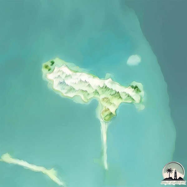
Welcome to Jiddah, a Dry island in the Persian Gulf, part of the majestic Indian Ocean. This guide offers a comprehensive overview of what makes Jiddah unique – from its geography and climate to its population, infrastructure, and beyond. Dive into the details:
Geography and size of Jiddah
Size: 0.57 km²
Coastline: 4.2 km
Ocean: Indian Ocean
Sea: Persian Gulf
Continent: Asia
Jiddah is a Tiny Island spanning 0.57 km² with a coastline of 4.2 km.
Archipel: –
Tectonic Plate: Arabia – A major tectonic plate covering the Arabian Peninsula and parts of the Middle East. The plate is primarily continental and known for its collision with the Eurasian Plate, leading to the uplift of the Zagros Mountains.
The geographic heart of the island is pinpointed at these coordinates:
Latitude: 26.19335613 / Longitude: 50.4045621
Climate and weather of Jiddah
Climate Zone: Dry
Climate Details: Hot Deserts Climate
Temperature: Hot
Climate Characteristics: Dominated by extremely hot temperatures, this climate is marked by minimal rainfall and barren landscapes. Nights often experience drastic temperature drops.
Topography and nature of Jiddah
Timezone: UTC+03:00
Timezone places: Asia/Riyadh
Max. Elevation: 2 m
Mean Elevation: 1 m
Vegetation: Sparse Vegetation
Tree Coverage: 8%
The mean elevation is 1 m. The highest elevation on the island reaches approximately 2 meters above sea level. The island is characterized by Plains: Flat, low-lying lands characterized by a maximum elevation of up to 200 meters. On islands, plains are typically coastal lowlands or central flat areas.
Dominating Vegetation: Sparse Vegetation
These regions have limited plant growth, typically due to extreme conditions like aridity or poor soils. Vegetation is scattered and consists of hardy plant species. Jiddah has a tree cover of 8 %.
Vegetation: 1 vegetation zones – Minimal Diversity Island
These islands exhibit the most basic level of ecological diversity, often characterized by a single dominant vegetation type. This could be due to extreme environmental conditions, limited land area, or significant human impact. They represent unique ecosystems where specific species have adapted to thrive in these singular environments.
Infrastructure and Travelling to Jiddah
Does the island have a public airport? no.
There is no public and scheduled airport on Jiddah. The nearest airport is Bahrain International Airport, located 26 km away.
Does the island have a major port? no.
There are no major ports on Jiddah. The closest major port is AL MANAMAH, approximately 20 km away.
The mean population of Jiddah is 3036 per km². Jiddah is Densely Populated. The island belongs to Bahrain.
Continuing your journey, Umm an Na‘sān is the next notable island, situated merely km away.
Jarada Island Kingdom of Bahrain "Dolce far niente"
The sweetness of doing nothing at Jarada Island near Bahrain #bahrain #bahrein #holiday #boattrip #jarada #weekend #leasure ...Jarada Island Kingdom of Bahrain "Dolce far niente"
The sweetness of doing nothing at Jarada Island near Bahrain #bahrain ...
The sweetness of doing nothing at Jarada Island near Bahrain #bahrain #bahrein #holiday #boattrip #jarada #weekend #leasure ...
kingdom of Bahrain island 🏝️,#island,#kingdom,#world trip,#Bahrainimportand place,#shorts
Bahrain island view @chellammavlogs9114.
Bahrain island view @chellammavlogs9114.
Durrat Al Bahrain 🇧🇭- Artificial Island time lapse #1984 - #2020 #shorts #reels #2022 #bahrain
Manama, Bahrain -- Content taken from Google Earth -- ...
Manama, Bahrain -- Content taken from Google Earth -- shorts,short,youtube shorts,best shorts,funny shorts,relatable shorts ...
AL JARADA ISLAND, BAHRAIN #traveling
Do you picture this when you think of Bahrain? The Kingdom of Bahrain ...
Do you picture this when you think of Bahrain? The Kingdom of Bahrain is full of surprises and a destination that needs to be ...
Experience the marine adventures of Jeddah
VisitSaudi #Jeddah #RedSea #Travel.
VisitSaudi #Jeddah #RedSea #Travel.
Al Dar Island Bahrain’s Ultimate Beach Escape and Snorkeling Spot!
Planning a trip to Bahrain in 2025? This video covers the top 10 ...
Planning a trip to Bahrain in 2025? This video covers the top 10 tourist spots you need to visit—from ancient forts and beach ...
Adventure On The Persian Gulf In Bahrain
This time, our friends from Bahrain Sea took us on a little boat ...
This time, our friends from Bahrain Sea took us on a little boat adventure on the Persian Gulf. From a shipwreck to a disappearing ...
Jeddah Island mosque 🕌❤️🤔🤲 #travel #shorts 
wonderful island 🏝️ at kingdom of Bahrain island view 🏝️,#bahrain ,#island ,#worltrip,#trending
island@chellammavlogs9114.
island@chellammavlogs9114.
Angry Iran Attacks US' Arab Allies: Bahrain, Qatar, UAE, Kuwait, Jordan, Saudi Arabia Under Fire
A dramatic escalation unfolded across West Asia as multiple U.S. ...
A dramatic escalation unfolded across West Asia as multiple U.S. military installations in the region reportedly came under Iranian ...
Visit Jarada Island on a Private Boat Trip - Bahrain
This disappearing "island" or sand bank will make you feel like you ...
This disappearing "island" or sand bank will make you feel like you are in the Maldives. The Cormorant bird, typical to Bahrain, ...
Discover the beauty of Amwaj Island in Bahrain! 🏝️breathtaking views #Bahrain #AmwajIsland #travel
Artificial Island in Arid Area|| Durrat Al Bahrein||#shorts ||#timelapse ||Bahrien Update||
Durrat Al Bahrain is the third largest artificial island in Bahrain ...
Durrat Al Bahrain is the third largest artificial island in Bahrain after Northern City and Diyar Al Muharraq Islands. It lies 40.5 km ...
Otw to the amazing Amwaj Island of Bahrain | Top Places To Visit | ALDRINATION VLOGS
AmwajIsland #Bahrain #aldrinationvlogs.
AmwajIsland #Bahrain #aldrinationvlogs.
Bahrain island #viral
bahrain,bahrain island,jarada island,reef island bahrain,amwaj islands ...
bahrain,bahrain island,jarada island,reef island bahrain,amwaj islands bahrain,island,bahrain reef island,#bahrain islands,al dar ...
The ultimate guide to Al Dar Island 2023 | Bahrain beaches
Visit the #Island for a day to swim in our lagoon or snorkel at the ...
Visit the #Island for a day to swim in our lagoon or snorkel at the artificial reef or Spend a night in one of 6 exclusive Chalets.
Al Dar Islands: The Perfect Day Trip in Manama, Bahrain
Are you in Manama, Bahrain? And you want the perfect day trip for you ...
Are you in Manama, Bahrain? And you want the perfect day trip for you and your family. Go to Al Dar Islands. It has real beaches, ...
Durrat Al Bahrain Island Expansion|| #shorts ||#timelapse ||#bahrain | توسعه جزایر مصنوعی در بحرین
Designed in two circular rows of 11 islands, The Islands are a ...
Designed in two circular rows of 11 islands, The Islands are a glorious visual treat and undoubtedly, the “crown jewel” of Durrat Al ...
Jaradha island Bahrain 🇧🇭
Map of the island nation of Bahrain #geography #mapping #virqlshorts #subscribe to
HAWAR ISLAND 🌴 Island in BAHRAIN 🇧🇭 #Vlog006 | Lovelicious Vlogs
Welcome to Hawar Island! Island in Bahrain #Vlog006 HAWAR ISLAND is an ...
Welcome to Hawar Island! Island in Bahrain #Vlog006 HAWAR ISLAND is an archipelago of desert island owned by Bahrain ...
#bahrain #island #viralvideo #viralshorts #flightdelays #shortsyoutube
Al dar island Bahrain 🇧🇭 #ksa #love #saudiaarbia #bahrain #aldar #aldar #island
Bahrain is classified as Developing region: Regions characterized by lower income levels, with economies in the process of industrialization and modernization. The level of income is High income: nonOECD.
News – Latest Updates and Headlines from Jiddah
Stay informed with the most recent news and important headlines from Jiddah. Here’s a roundup of the latest developments.
Loading...
Please note: The data used here has been primarily extracted from satellite readings. Deviations from exact values may occur, particularly regarding the height of elevations and population density. Land area and coastline measurements refer to average values at mean high tide.