Welcome to Kagbeli, a Tropical island in the North Atlantic Ocean, part of the majestic Atlantic Ocean. This guide offers a comprehensive overview of what makes Kagbeli unique – from its geography and climate to its population, infrastructure, and beyond. Dive into the details:
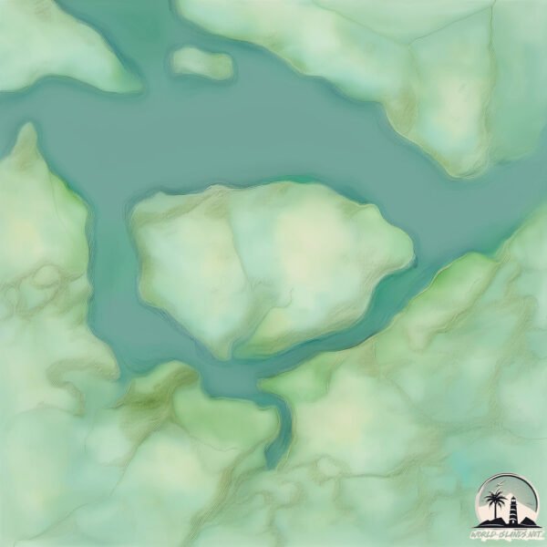
Geography and size of Kagbeli
Size: 7.977 km²
Coastline: 11.9 km
Ocean: Atlantic Ocean
Sea: North Atlantic Ocean
Continent: Africa
Kagbeli is a Small Island spanning 8 km² with a coastline of 11.9 km.
Archipel: –
Tectonic Plate: South America – A major plate covering the South American continent and part of the Atlantic Ocean, known for the Andes mountain range and significant seismic and volcanic activity.
The geographic heart of the island is pinpointed at these coordinates:
Latitude: 8.54504762 / Longitude: -12.94421564
Climate and weather of Kagbeli
Climate Zone: Tropical
Climate Details: Tropical Monsoon Climate
Temperature: Hot
Climate Characteristics: Characterized by heavy rainfall, high humidity, and uniformly high temperatures, but with a distinct short dry season. It features a seasonal reversal of prevailing wind directions.
Topography and nature of Kagbeli
Timezone: UTC±00:00
Timezone places: Europe/Lisbon
Max. Elevation: 7 m
Mean Elevation: 1 m
Vegetation: Evergreen Broadleaf Forest
Tree Coverage: 57%
The mean elevation is 1 m. The highest elevation on the island reaches approximately 7 meters above sea level. The island is characterized by Plains: Flat, low-lying lands characterized by a maximum elevation of up to 200 meters. On islands, plains are typically coastal lowlands or central flat areas.
Dominating Vegetation: Evergreen Broadleaf Forest
Characterized by dense, lush canopies of broadleaf trees that retain their leaves year-round. These forests are typically found in tropical and subtropical regions and are known for their high biodiversity. Kagbeli has a tree cover of 57 %.
Vegetation: 6 vegetation zones – Very Highly Diverse Island
Islands in this range are ecological powerhouses, showcasing a wide array of vegetation zones. Each zone, from lush rainforests to arid scrublands, coastal mangroves to mountainous regions, contributes to a complex and interdependent ecosystem. These islands are often hotspots of biodiversity, supporting numerous species and intricate ecological processes.
Infrastructure and Travelling to Kagbeli
Does the island have a public airport? no.
There is no public and scheduled airport on Kagbeli. The nearest airport is Lungi International Airport, located 27 km away.
Does the island have a major port? no.
There are no major ports on Kagbeli. The closest major port is PEPEL, approximately 10 km away.
The mean population of Kagbeli is 73 per km². Kagbeli is Gently Populated. The island belongs to Sierra Leone.
Continuing your journey, Sherbro is the next notable island, situated merely km away.
Sierra Leone name top tourist destination for 2023 . The Freetown Pennesula.
News of Salone Today. Sierra Leone.Sierra Leone name top tourist destination for 2023 . The Freetown Pennesula.
News of Salone Today. Sierra Leone.
News of Salone Today. Sierra Leone.
Welcome To BIG WATER / WHALE BAY 🇸🇱 FREETOWN PENINSULAR - VLog 2024 - Explore With Triple-A
explore #kenemacity #bokakua #roadtrip #sierraleone #portloko ...
explore #kenemacity #bokakua #roadtrip #sierraleone #portloko #sugarloafmountain #tokehsierraleone #tokehbeach ...
FREETOWN PENINSULAR BEACHES
This video is about sierra leone Freetown peninsular ! whale bay ...
This video is about sierra leone Freetown peninsular ! whale bay sierra leone.
A RESORT WITH PRIVATE BEACHFRONT, EDEN PARK RESORT FREETOWN FT VIRTUE GRACE. #FREETOWN#VIRTUEGRACE
Eden Park Resort HOTEL DETAILS Facilities Beach-Front Conference Gym ...
Eden Park Resort HOTEL DETAILS Facilities Beach-Front Conference Gym Restaurant Swimming Pool Weddings Wireless ...
The most beautiful beach in freetown Sierra Leone 🇸🇱// pay a visit to No 2 beach 🏖
Hi guys welcome to my YouTube channel. Number 2 beache is the most ...
Hi guys welcome to my YouTube channel. Number 2 beache is the most beautiful place to be at if you want to experience nature ...
IS THIS THE MOST BEAUTIFUL PLACE & RESORT IN FREETOWN, SIERRA LEONE🇸🇱? ESTUARY RESORT OF JOHN OBEY
The Estuary Resort: Sierra Leone is endowed with natural beauty, ...
The Estuary Resort: Sierra Leone is endowed with natural beauty, evident in its natural coastal line, attractive beaches, its unique ...
This Country Is Blessed With Beautiful Beaches. Sugar Land Beach, Freetown, Sierra Leone.
There are so many beaches in Sierra Leone, each with its own ...
There are so many beaches in Sierra Leone, each with its own uniqueness. Not so crowded so it is a great place for relaxation ...
SIERRA LEONE CAPITAL CITY FREETOWN MODERNIZATION .
Welcome To BAWBAW VILLAGE 🇸🇱 FREETOWN WEST - VLog 2024 - Explore With Triple-A
explore #kenemacity #bokakua #roadtrip #sierraleone #portloko ...
explore #kenemacity #bokakua #roadtrip #sierraleone #portloko #sugarloafmountain #tokehsierraleone #tokehbeach ...
A Beautiful Golden Sand Beach With An Island LAKKA BEACH. Freetown Sierra Leone #Freetownbeaches
Lakka is a coastal resort town around the Freetown Peninsular in the ...
Lakka is a coastal resort town around the Freetown Peninsular in the Western Area Rural District of Sierra Leone. The town lies ...
SIERRA LEONE: Black market money! From golden beaches on the Freetown Penninsula to Bo // EPS 10
Why are there places on earth, you only hear negative things about? ...
Why are there places on earth, you only hear negative things about? Like Sierra Leone - the only references to this country in the ...
Freetown peninsula tour - 2024
OUR VISIT TO KENT BEACH, WESTERN PENINSULA, FREETOWN, SIERRA LEONE
Kent Beach is one of the most beautiful beaches in Sierra Leone. It ...
Kent Beach is one of the most beautiful beaches in Sierra Leone. It mostly host few number of people who go there recreational ...
WEDNESDAY WALKAROUND - WESTERN AREA RURAL 🇸🇱 Vlog 2022 - Explore With Triple-A
explore #FREETOWN #bokakua #lunsar #roadtrip #sierraleone #portloko ...
explore #FREETOWN #bokakua #lunsar #roadtrip #sierraleone #portloko #sugarloafmountain #tokehsierraleone #tokehbeach ...
Lost Freetown - teaser
Promo for a 30 minute documentary about the ecological issues facing ...
Promo for a 30 minute documentary about the ecological issues facing the Freetown Peninsula, Sierra Leone.
Development around Freetown Peninsular in the last 10 years, Adonkia, Tokeh - Kabor Apartments
kaborapartments #kaborestate #property Contact us: ...
River Number Two Beach in Freetown, Sierra Leone
River Number Two Beach in Freetown, Sierra Leone Possibly Sierra ...
River Number Two Beach in Freetown, Sierra Leone Possibly Sierra Leone's most beautiful beach, River Number Two is just 30 ...
This is Leicester Peak in Freetown Sierra Leone:
Leicester Peak is located in freetown western area in sierra Leone.The ...
Leicester Peak is located in freetown western area in sierra Leone.The site is located on top of the mountain of the same name.
EXPLORING THE MOST FAMOUS WATERFALL IN FREETOWN, SIERRA LEONE. MAMBO WATERFALL.
Mambo Waterfall is an instant charmer for those who love to hike, ...
Mambo Waterfall is an instant charmer for those who love to hike, those who love to take adventure & those who would want to ...
Sierra Leone | Freetown | Bureh Town | Bureh Beach
The Two most busy Places in Freetown.
If you have been in freetown or live there, you must have heard the ...
If you have been in freetown or live there, you must have heard the name of these two places. Eastern Police and PZ. They are the ...
Major Streets & Roads in Freetown// Ross Road to Cline Street// Street Walking Tour
Major Streets & Roads in Freetown// Ross Road to Cline Street is a ...
Major Streets & Roads in Freetown// Ross Road to Cline Street is a video in my new Street Walk series. I made it to Displore ...
Freetown Sierra Leone - River No 2 Beach: A cinematic Experience
Sierra Leone's mesmerizing beaches, Explore River No. 2 along the ...
Sierra Leone's mesmerizing beaches, Explore River No. 2 along the Freetown peninsula. Follow me on social media for more ...
LIST OF MOST VISITED BEACHES IN FREETOWN SIERRA LEONE
Please Subscribe to our YouTube Channel. #travel #tourism #sabinus ...
Please Subscribe to our YouTube Channel. #travel #tourism #sabinus #macaroni #9jamusic #comedy.
Road to Sussex Beach, Freetown Peninsula
Sierra Leone is classified as Least developed region: Countries that exhibit the lowest indicators of socioeconomic development, with the lowest Human Development Index ratings. The level of income is Low income.
News – Latest Updates and Headlines from Kagbeli
Stay informed with the most recent news and important headlines from Kagbeli. Here’s a roundup of the latest developments.
Loading...
Please note: The data used here has been primarily extracted from satellite readings. Deviations from exact values may occur, particularly regarding the height of elevations and population density. Land area and coastline measurements refer to average values at mean high tide.