Welcome to Kameriye Adasi, a Temperate island in the Aegean Sea, part of the majestic Atlantic Ocean. This guide offers a comprehensive overview of what makes Kameriye Adasi unique – from its geography and climate to its population, infrastructure, and beyond. Dive into the details:
Geography and size of Kameriye Adasi
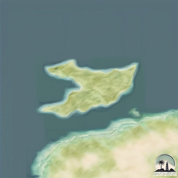
Size: 1.208 km²
Coastline: 6.1 km
Ocean: Atlantic Ocean
Sea: Aegean Sea
Continent: Asia
Kameriye Adasi is a Small Island spanning 1.2 km² with a coastline of 6.1 km.
Archipel: –
Tectonic Plate: Aegean Sea – Located in the eastern Mediterranean, this microplate is characterized by seismic and volcanic activity due to its interaction with the Eurasian and African Plates.
The geographic heart of the island is pinpointed at these coordinates:
Latitude: 36.72979698 / Longitude: 28.05530259
Climate and weather of Kameriye Adasi
Climate Zone: Temperate
Climate Details: Hot-Summer Mediterranean Climate
Temperature: Hot Summer
Climate Characteristics: Characterized by hot, dry summers and mild, wet winters, typical of coastal areas with abundant sunshine.
Topography and nature of Kameriye Adasi
Timezone: UTC+02:00
Timezone places: Europe/Mariehamn
Max. Elevation: 48 m
Mean Elevation: 40 m
Vegetation: Sparse Vegetation with Trees/Shrubs
Tree Coverage: 44%
The mean elevation is 40 m. The highest elevation on the island reaches approximately 48 meters above sea level. The island is characterized by Plains: Flat, low-lying lands characterized by a maximum elevation of up to 200 meters. On islands, plains are typically coastal lowlands or central flat areas.
Dominating Vegetation: Sparse Vegetation with Trees/Shrubs
Areas where grasses and other herbaceous plants are prevalent, but with occasional presence of trees and shrubs. Often found in semi-arid regions or grasslands. Kameriye Adasi has a tree cover of 44 %.
Vegetation: 3 vegetation zones – Moderately Diverse Island
These islands start to show a broader range of ecological niches. With three vegetation zones, they may offer a mix of ecosystems like coastal areas, inland woods, and perhaps a distinct wetland or dry area. This diversity supports a wider range of flora and fauna, making these islands more ecologically complex than those with minimal diversity.
Infrastructure and Travelling to Kameriye Adasi
Does the island have a public airport? no.
There is no public and scheduled airport on Kameriye Adasi. The nearest airport is Diagoras Airport, located 36 km away.
Does the island have a major port? no.
There are no major ports on Kameriye Adasi. The closest major port is MARMARIS, approximately 27 km away.
The mean population of Kameriye Adasi is 91 per km². Kameriye Adasi is Gently Populated. The island belongs to Turkey.
Continuing your journey, Nisí Sými is the next notable island, situated merely km away.
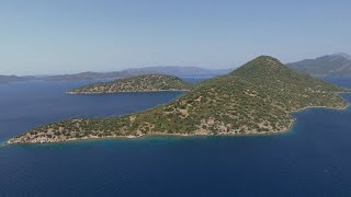
Masmavi Deniziyle Kameriye Adası | Selimiye | Marmaris (Drone Gözüyle)
Selimiye, Bozburun taraflarında yaptığımız tekne turunda beni en çok etkileyen yerlerden birisi de Kameriye diğer adıyla Kamelya ...Masmavi Deniziyle Kameriye Adası | Selimiye | Marmaris (Drone Gözüyle)
Selimiye, Bozburun taraflarında yaptığımız tekne turunda beni en çok ...
Selimiye, Bozburun taraflarında yaptığımız tekne turunda beni en çok etkileyen yerlerden birisi de Kameriye diğer adıyla Kamelya ...
Kameriye Adası
Kameriye Adası, Selimiye mahallesi yakınlarında, Simi adası yönündeki ...
Kameriye Adası, Selimiye mahallesi yakınlarında, Simi adası yönündeki ilk adadır. Ada üzerinde bulunan ve tarihine ilişkin kesin ...
KAMERİYE ADASI, KAMERIYE ISLAND - Sailing Dive Liveaboard MSY OKYANUS JD -TURKEY
Birisi bu güzel mozaikleri korumak için bir şey yapmalı. Somebody must ...
Birisi bu güzel mozaikleri korumak için bir şey yapmalı. Somebody must do something to protect the mosaics.
Kameriye Adası Beach
Kameriye Adası Selimiye mahallesi yakınlarında, Simi adası yönündeki ...
Kameriye Adası Selimiye mahallesi yakınlarında, Simi adası yönündeki ilk adadır. Ada üzerinde bulunan ve tarihine ilişkin kesin ...
Kamelya Adası - Kamelya Island
Kamelya Adası - Kamelya Island #marmaris #selimiye #marmarisbeach ...
Kamelya Adası - Kamelya Island #marmaris #selimiye #marmarisbeach #island #summer #bluecruise #bluevoyage #turkei #fun ...
Kameriye Adası
Kameriye Adası Selimiye mahallesi yakınlarında, Simi adası yönündeki ...
Kameriye Adası Selimiye mahallesi yakınlarında, Simi adası yönündeki ilk adadır. Ada üzerinde bulunan ve tarihine ilişkin kesin ...
#Marmaris - #Hisarönü Boat Trip - Kameriye Island - Yummy Bunnies
Akyaka #Alanya #Fethiye #Kemer #Marmaris #Ölüdeniz.
Akyaka #Alanya #Fethiye #Kemer #Marmaris #Ölüdeniz.
Kameriye Adası’nı daha detaylı bir şekilde profilimde görebilirsiniz ✨ #marmaris #kameriye #muğla
Gulf of Hisaronu day cruise: streaming around Kameriye Island and sailing to Datca Peninsula.
#Marmaris - #Kameriye Island - Very Cool Natural Spots - #Turkey
Akyaka #Alanya #Fethiye #Kemer #Marmaris #Ölüdeniz.
Akyaka #Alanya #Fethiye #Kemer #Marmaris #Ölüdeniz.
TR #Marmaris #Hisarönü Best Boat Trip Today - #Kameriye Island - Awesome Views Indeed
Akyaka #Alanya #Fethiye #Kemer #Marmaris #Ölüdeniz.
Akyaka #Alanya #Fethiye #Kemer #Marmaris #Ölüdeniz.
2020 DORİS NO.15-SELİMİYE-SIĞ LİMAN-KAMERİYE ADASI-TEKNEDE YAŞAM-MACGREGOR-YELKENLİ VE MOTORLU ÇİFT
YELKENLİMİZ DORİS 2025- 24 KAMERİYE ADASINA YELKEN AÇTIK- SIĞLİMAN - YELKENLİ VE MOTORLU ÇİFT
24 HİSARÖNÜ KÖRFEZİ'nde 1.Video SEZONA HAZIRLIK - A'dan Z'ye linki: ...
#Marmaris Boat Trip - Yummy Boat Bunnies - Awesome Views
Akyaka #Alanya #Fethiye #Kemer #Marmaris #Ölüdeniz #shorts #short ...
Akyaka #Alanya #Fethiye #Kemer #Marmaris #Ölüdeniz #shorts #short #youtubeshorts #shortsfeed.
#Marmaris Boat Trip - Yummy Boat Bunnies - Awesome Views
Akyaka #Alanya #Fethiye #Kemer #Marmaris #Ölüdeniz #shorts #short ...
Akyaka #Alanya #Fethiye #Kemer #Marmaris #Ölüdeniz #shorts #short #youtubeshorts #shortsfeed.
YELKENLİ TEKNE TEKNEDE YAŞAM Marmaris Orhaniye Kızkumu Plajı Kameriye Adası BOZBURUN
Bu Videodaki Görüntüler Ağustos 2020 Yılına Aittir. Bu Bölümde ; ...
Bu Videodaki Görüntüler Ağustos 2020 Yılına Aittir. Bu Bölümde ; Orhaniye'den Bozburun'a uzanan deniz maceramızı sizlerle ...
#Marmaris - Boat Trip -#Kameriye Island - Awesome Views - 4K 60 Fps
Akyaka #Alanya #Fethiye #Kemer #Marmaris #Ölüdeniz.
Akyaka #Alanya #Fethiye #Kemer #Marmaris #Ölüdeniz.
Ege Adaları, Kamelya Adası🌴
⛰️Kameriye Adası / Marmaris / Muğla🔆Türkiye / Turkey
Sedir Adası Marmaris Muğla | Kleopatra Adası Marmaris Muğla | Çamlı köyü sedir kleopatra island
çamli köyünde ücretsiz otoparka aracinizi bıraktıktan sonra kişi başı ...
çamli köyünde ücretsiz otoparka aracinizi bıraktıktan sonra kişi başı 100 TL karşılığında tekne ile adaya 20 25 dk gibi bir surede ...
KAMERİYE ADASI | SELİMİYE | MARMARİS | #keşfet #youtubeshorts
#Marmaris - #Kameriye Island - Most Awesome Views - 4K 60 Fps
Akyaka #Alanya #Fethiye #Kemer #Marmaris #Ölüdeniz.
Akyaka #Alanya #Fethiye #Kemer #Marmaris #Ölüdeniz.
Kamelya Adası - Manastır / Marmaris (Camelia island)
#Marmaris - #Kameriye Island - September 2019 - 4K UHD - 60FPS
Akyaka #Alanya #Fethiye #Kemer #Marmaris #Ölüdeniz.
Akyaka #Alanya #Fethiye #Kemer #Marmaris #Ölüdeniz.
#Marmaris - #Kameriye Island - Goat Feeding - Truly Awesome Views
Akyaka #Alanya #Fethiye #Kemer #Marmaris #Ölüdeniz.
Akyaka #Alanya #Fethiye #Kemer #Marmaris #Ölüdeniz.
Turkey is classified as Emerging region: MIKT: Mexico, Indonesia, South Korea, and Turkey – Economies recognized for their development potential and emerging market status. The level of income is Upper middle income.
News – Latest Updates and Headlines from Kameriye Adasi
Stay informed with the most recent news and important headlines from Kameriye Adasi. Here’s a roundup of the latest developments.
Loading...
Please note: The data used here has been primarily extracted from satellite readings. Deviations from exact values may occur, particularly regarding the height of elevations and population density. Land area and coastline measurements refer to average values at mean high tide.