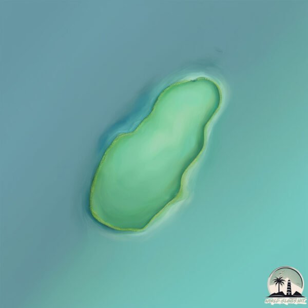
Welcome to Kaôh Mano, a Tropical island in the Gulf of Thailand, part of the majestic Pacific Ocean. This guide offers a comprehensive overview of what makes Kaôh Mano unique – from its geography and climate to its population, infrastructure, and beyond. Dive into the details:
Geography and size of Kaôh Mano
Size: 0.167 km²
Coastline: 1.7 km
Ocean: Pacific Ocean
Sea: Gulf of Thailand
Continent: Asia
Kaôh Mano is a Tiny Island spanning 0.167 km² with a coastline of 1.7 km.
Archipel: –
Tectonic Plate: Sunda – Extends across Southeast Asia, encompassing parts of the Sunda Shelf, known for its interaction with the Australian Plate, contributing to volcanic activity in Indonesia.
The geographic heart of the island is pinpointed at these coordinates:
Latitude: 10.83791526 / Longitude: 103.17311877
Climate and weather of Kaôh Mano
Climate Zone: Tropical
Climate Details: Tropical Monsoon Climate
Temperature: Hot
Climate Characteristics: Characterized by heavy rainfall, high humidity, and uniformly high temperatures, but with a distinct short dry season. It features a seasonal reversal of prevailing wind directions.
Topography and nature of Kaôh Mano
Timezone: UTC+07:00
Timezone places: Asia/Jakarta
Max. Elevation: 5 m
Mean Elevation: 5 m
Vegetation: Evergreen Broadleaf Forest
Tree Coverage: 67%
The mean elevation is 5 m. The highest elevation on the island reaches approximately 5 meters above sea level. The island is characterized by Plains: Flat, low-lying lands characterized by a maximum elevation of up to 200 meters. On islands, plains are typically coastal lowlands or central flat areas.
Dominating Vegetation: Evergreen Broadleaf Forest
Characterized by dense, lush canopies of broadleaf trees that retain their leaves year-round. These forests are typically found in tropical and subtropical regions and are known for their high biodiversity. Kaôh Mano has a tree cover of 67 %.
Vegetation: 1 vegetation zones – Minimal Diversity Island
These islands exhibit the most basic level of ecological diversity, often characterized by a single dominant vegetation type. This could be due to extreme environmental conditions, limited land area, or significant human impact. They represent unique ecosystems where specific species have adapted to thrive in these singular environments.
Infrastructure and Travelling to Kaôh Mano
Does the island have a public airport? no.
There is no public and scheduled airport on Kaôh Mano. The nearest airport is Sihanoukville International Airport, located 59 km away.
Does the island have a major port? no.
There are no major ports on Kaôh Mano. The closest major port is KAMPONG SAOM, approximately 43 km away.
The mean population of Kaôh Mano is 7 per km². Kaôh Mano is Gently Populated. The island belongs to Cambodia.
Continuing your journey, Kaoh Rung is the next notable island, situated merely km away.
🌄 The Best Samui - Overlap Stone - Koh Samui - Thailand #kohsamui #thailand #travel #bestview
The Best Samui” – Koh Samui's hidden rock wonder with a view! Some places look great in photos – but hit different in real life.🌄 The Best Samui - Overlap Stone - Koh Samui - Thailand #kohsamui #thailand #travel #bestview
The Best Samui” – Koh Samui's hidden rock wonder with a view! Some ...
The Best Samui” – Koh Samui's hidden rock wonder with a view! Some places look great in photos – but hit different in real life.
Insane Kitesurfer Jumps Over A Small Island 😱🤯
Subscribe For Daily Kitesurfing Content⭐️ Rider ♂️: @jinneboer629 ...
Subscribe For Daily Kitesurfing Content⭐️ Rider ♂️: @jinneboer629 ...
Koh kood paradise on earth 🌍🏝️ #vlog #beach #island #travel
Komodo Dragon VS Sick Lion Encounter in The Wild! #wildlife #komododragon #lion
The Komodo dragon is poisonous and can easily kill a lion with a ...
The Komodo dragon is poisonous and can easily kill a lion with a single drop of its venom. Lions generally do not want to ...
Koh Samui ESSENTIAL guide for your 2026 travel
Welcome to the ultimate Koh Samui travel guide! In this video, I'll ...
Welcome to the ultimate Koh Samui travel guide! In this video, I'll take you on a tour of this tropical paradise located in the Gulf of ...
10 Minutes to Paradise Koh Larn Day & Night
In this vlog we visit 3 beaches on Koh Larn which includes Taya & ...
In this vlog we visit 3 beaches on Koh Larn which includes Taya & Monkey Beach plus the very busy day tripper beach but we ...
catching a HUGE iguana!!!
Journey to a Hidden Abandoned ISLAND Mansion
Watch all episodes of Abandoned Spain Season 2 right here: ...
Watch all episodes of Abandoned Spain Season 2 right here: ...
I Found a Massive Gold Chain on the Beach with My Metal Detector! #bestmetaldetector #treasuresearch
I Found a Massive Gold Chain on the Beach with My Metal Detector! ...
I Found a Massive Gold Chain on the Beach with My Metal Detector! #bestmetaldetector #treasuresearch I found a huge gold ...
L'épreuve des radeaux ravive les tensions... | EP03 Complet | Koh Lanta 2026 Reliques du Destin
Retrouver la saison 2026 de Koh Lanta : Les Reliques du Destin ! Fan ...
Retrouver la saison 2026 de Koh Lanta : Les Reliques du Destin ! Fan de l'émission Koh-Lanta ? L'intégrale des émissions est ...
10 Worst THAILAND Packing Mistakes
Don't make these packing mistakes on your trip to THAILAND. SUPPORT ...
Don't make these packing mistakes on your trip to THAILAND. SUPPORT Buy me a cup of coffee: ...
#memes #funny #cocomartin #nescafe #haha
🇧🇷 Shark Attack | Rio De Janeiro Atlantic Ocean #shark #travel #subscribe #comedy #brazil #ocean
thebestofrio4244 #travel #comedy #subscribe #brazil Just for laughs.
thebestofrio4244 #travel #comedy #subscribe #brazil Just for laughs.
The Art of Tantra: A Transformative Workshop at Co~Nectar Festival #tantra #consciousgrowth
Anaya Ye Kaise Kar Rahi Hai 😱
How I like to start when it’s super light #wingfoil
Expats Over 50: Living Healthy & Happy on Koh Phangan,THAILAND
In this video, I explore why expats over 50 live on a peaceful island ...
In this video, I explore why expats over 50 live on a peaceful island in Thailand, focusing on what makes it an ideal destination for ...
The Virgin Beauty of Koh Chang Island 😍 #viral #trending #shorts
The Virgin Beauty of Koh Chang Island #viral #trending #shorts #viral ...
The Virgin Beauty of Koh Chang Island #viral #trending #shorts #viral #explorepage #trending #explore #instagram #tiktok ...
Snorkeling the Mysterious Emerald Cave in Thailand
If you're scared of the dark, a trip through Emerald Cave may not be ...
If you're scared of the dark, a trip through Emerald Cave may not be for you. But if you can release those fears for a little while, the ...
KOH CHANG 🇹🇭 Quest'isola della THAILANDIA è PAZZESCA! Ecco perchè dovete venire qua [Sub-Eng]
Benvenuti a KOH CHANG, una splendida isola della Thailandia di cui mi ...
Benvenuti a KOH CHANG, una splendida isola della Thailandia di cui mi sono totalmente innamorato! Ho passato 3 giorni qui e in ...
Best Hostel for solo backpackers #goa #hostelworld #backpacking #solotravel #solotrip #goatrip #vlog
💥 Evolution of Spider-Man 🥰 Avengers Evolution ✅ #shorts #marvel #avengers #spiderman
avengers Vs DC DC Vs avengers marvel Vs DC avengers Vs justice league ...
avengers Vs DC DC Vs avengers marvel Vs DC avengers Vs justice league hulk Vs ironman Spiderman Vs venom superman Vs ...
wow That's awesome food made by hadzabe tribe to survive #hadzabetribe #food
How To Get INFINITE Mushrooms Out of Your Blocks
Hadzabe tribe playing beautiful songs 🎵🎼🎶
Cambodia is classified as Least developed region: Countries that exhibit the lowest indicators of socioeconomic development, with the lowest Human Development Index ratings. The level of income is Low income.
News – Latest Updates and Headlines from Kaôh Mano
Stay informed with the most recent news and important headlines from Kaôh Mano. Here’s a roundup of the latest developments.
Loading...
Please note: The data used here has been primarily extracted from satellite readings. Deviations from exact values may occur, particularly regarding the height of elevations and population density. Land area and coastline measurements refer to average values at mean high tide.


![KOH CHANG 🇹🇭 Quest'isola della THAILANDIA è PAZZESCA! Ecco perchè dovete venire qua [Sub-Eng]](https://i.ytimg.com/vi/r4JUS-xAYT8/mqdefault.jpg)