Karaginsky
Welcome to Karaginsky, a Continental island in the Bering Sea, part of the majestic Pacific Ocean. This guide offers a comprehensive overview of what makes Karaginsky unique – from its geography and climate to its population, infrastructure, and beyond. Dive into the details:
- Geography and Size: Explore the island’s size and location.
- Climate and Weather: Weather patterns and temperature.
- Topography and Nature: Uncover the natural wonders of the island.
- Infrastructure and Travelling: Insights on reaching, staying, and making the most of your visit.
- News and Headlines: Latest News.
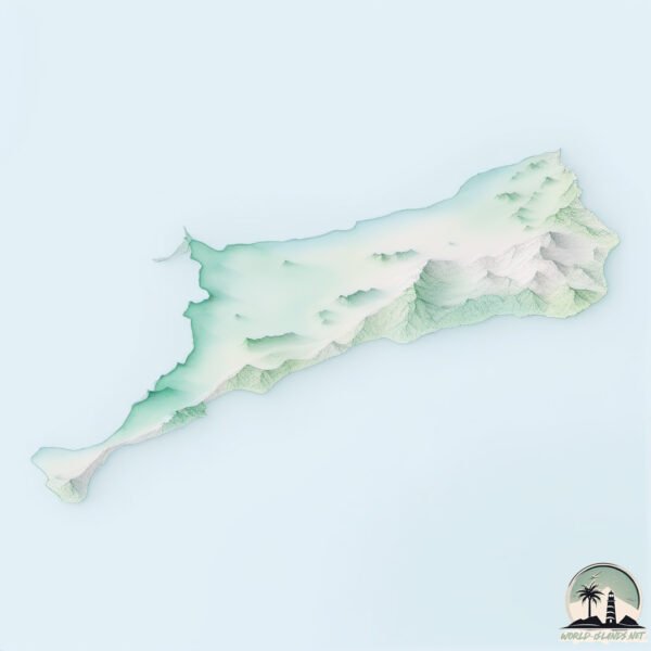
Geography and size of Karaginsky
Size: 1926 km²
Coastline: 418 km
Ocean: Pacific Ocean
Sea: Bering Sea
Continent: Asia
Karaginsky is a Very Large Island spanning 1926 km² with a coastline of 418 km.
Archipel: –
Tectonic Plate: Okhotsk – Located in the northwest Pacific Ocean, the Okhotsk Plate encompasses the Sea of Okhotsk, the Kamchatka Peninsula, and parts of Japan. It’s involved in complex interactions with the Pacific and North American plates, contributing to seismic activity in the region.
The geographic heart of the island is pinpointed at these coordinates:
Latitude: 58.9180484 / Longitude: 164.18697818
Climate and weather of Karaginsky
Climate Zone: Continental
Climate Details: Subarctic Climate
Temperature: Cold Summer
Climate Characteristics: Characterized by long, extremely cold winters and short, cool summers, often found in northern latitudes of North America and Eurasia.
Topography and nature of Karaginsky
Timezone: UTC+12:00
Timezone places: Asia/Kamchatka
Max. Elevation: 775 m
Mean Elevation: 163 m
Vegetation: Herbaceous Cover
Tree Coverage: 24%
The mean elevation is 163 m. The highest elevation on the island reaches approximately 775 meters above sea level. The island is characterized by Plateau: Elevated flatlands rising sharply above the surrounding area, with a maximum elevation over 500 meters but a mean elevation less than 300 meters, forming unique highland areas on islands.
Dominating Vegetation: Herbaceous Cover
Comprising mainly of grasses, herbs, and ferns, these areas are common in prairies, meadows, and savannas, and can vary widely in species composition. Karaginsky has a tree cover of 24 %.
Vegetation: 9 vegetation zones – Very Highly Diverse Island
Islands in this range are ecological powerhouses, showcasing a wide array of vegetation zones. Each zone, from lush rainforests to arid scrublands, coastal mangroves to mountainous regions, contributes to a complex and interdependent ecosystem. These islands are often hotspots of biodiversity, supporting numerous species and intricate ecological processes.
Infrastructure and Travelling to Karaginsky
Does the island have a public airport? no.
There is no public and scheduled airport on Karaginsky. The nearest airport is Ust’-Kamchatsk Airport, located 261 km away.
Does the island have a major port? no.
There are no major ports on Karaginsky. The closest major port is NIKOL SKOYE, approximately 434 km away.
The mean population of Karaginsky is 0 per km². Karaginsky is Uninhabited. The island belongs to Russia.
The name of the island resonates across different cultures and languages. Here is how it is known around the world: Arabic: جزيرة كاراجينسكي; German: Karaginski; Spanish: Isla Karaginsky; French: île Karaguinski; Portuguese: Ilha Karaginsky; Russian: Карагинский; Chinese: 卡拉金斯克島
Continuing your journey, Ostrov Tretiy is the next notable island, situated merely km away.
Karaginsky Island Russia


Russia is classified as Emerging region: BRIC: Brazil, Russia, India, and China – Economies noted for their rapid growth and increasing influence on global affairs. The level of income is Upper middle income.
News – Latest Updates and Headlines from Karaginsky
Stay informed with the most recent news and important headlines from Karaginsky. Here’s a roundup of the latest developments.
Social Media Posts about Karaginsky
Please note: The data used here has been primarily extracted from satellite readings. Deviations from exact values may occur, particularly regarding the height of elevations and population density. Land area and coastline measurements refer to average values at mean high tide.