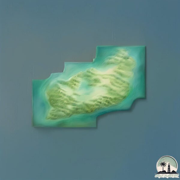
Welcome to Karpa, a Continental island in the Gulf of Alaska, part of the majestic Pacific Ocean. This guide offers a comprehensive overview of what makes Karpa unique – from its geography and climate to its population, infrastructure, and beyond. Dive into the details:
Geography and size of Karpa
Size: 1.705 km²
Coastline: 11.3 km
Ocean: Pacific Ocean
Sea: Gulf of Alaska
Continent: North America
Karpa is a Small Island spanning 1.7 km² with a coastline of 11.3 km.
Archipel: Aleutian Islands – A chain of islands stretching from Alaska to Russia, known for their rugged beauty, abundant wildlife, and volcanic activity.
Tectonic Plate: North America – Covers North America and parts of the Atlantic and Arctic Oceans, characterized by diverse geological features and varying levels of seismic activity.
The geographic heart of the island is pinpointed at these coordinates:
Latitude: 55.50920685 / Longitude: -160.05136663
Climate and weather of Karpa
Climate Zone: Continental
Climate Details: Subarctic Climate
Temperature: Cold Summer
Climate Characteristics: Characterized by long, extremely cold winters and short, cool summers, often found in northern latitudes of North America and Eurasia.
Topography and nature of Karpa
Timezone: UTC-09:00
Timezone places: America/Anchorage
Max. Elevation: 314 m
Mean Elevation: 158 m
Vegetation: Deciduous Needleleaf Forest
Tree Coverage: 80%
The mean elevation is 158 m. The highest elevation on the island reaches approximately 314 meters above sea level. The island is characterized by Hills: Gently sloping landforms with rounded tops, having a maximum elevation between 200 and 500 meters. Hills contribute to a varied landscape on islands.
Dominating Vegetation: Deciduous Needleleaf Forest
Consists of needleleaf trees that shed their needles annually. This type of forest is less common and can be found in certain cold, northern regions. Karpa has a tree cover of 80 %.
Vegetation: 4 vegetation zones – Diverse Island
Four distinct vegetation zones mark these islands as ecologically diverse. They might feature varied landscapes such as forests, beaches, grasslands, and rocky areas. Such diversity reflects the island’s complex ecological interactions and varied habitats, which can support a rich array of wildlife and plant species.
Infrastructure and Travelling to Karpa
Does the island have a public airport? no.
There is no public and scheduled airport on Karpa. The nearest airport is Chignik Lake Airport, located 163 km away.
Does the island have a major port? no.
There are no major ports on Karpa. The closest major port is SAND POINT, approximately 55 km away.
The mean population of Karpa is 0 per km². Karpa is Uninhabited. The island belongs to United States of America.
Continuing your journey, Andronica is the next notable island, situated merely km away.
Karpathos, Greece | Top 10 BEST PLACES to VISIT
Karpathos is a Greek island that feels much bigger than it really is It is famous for it's beaches and mountain villages Let me show ...Karpathos, Greece | Top 10 BEST PLACES to VISIT
Karpathos is a Greek island that feels much bigger than it really is ...
Karpathos is a Greek island that feels much bigger than it really is It is famous for it's beaches and mountain villages Let me show ...
Discovering a Massive School of Tilapia Fish in a Local Pond
Join me as I uncover a surprising abundance of tilapia fish in a ...
Join me as I uncover a surprising abundance of tilapia fish in a nearby pond! This exciting fishing adventure not only highlights the ...
#giantsquidwithsoidershells #giantsquid #seafood #mukbang
Is this effective? #carp #fishing #fish
shortswithcamilla #shorts #youtubeshorts #fyp #tiktok #viral #reels ...
shortswithcamilla #shorts #youtubeshorts #fyp #tiktok #viral #reels #trending #vlog #new #motivation.
How to catch Carp with KastKing!
What do you use? @Hunterdubs.fwtx #KastKing #fishingreels ...
What do you use? @Hunterdubs.fwtx #KastKing #fishingreels #fishingvideo #carp #carpfishing #fishing #howto.
How Tilapia Fish Eat Bait #shorts #fishing #tutorial
Cooking Large Fish in the Oven! 🔥
Cooking Large Fish in the Oven! \ #food #cooking #fish.
Cooking Large Fish in the Oven! \ #food #cooking #fish.
The Unbelievable & Greatest Natural Wonders of Palawan
Narito po ang ating masayang paglalakbay at exploration sa Balabac ...
Narito po ang ating masayang paglalakbay at exploration sa Balabac Palawan. Ating pinasyalan ang mga hidden gems mula sa ...
Part2 || PagDayo sa Mystery Island ng Taal Vulcano || May bunos pang Karpa X Batangeñong Maninisid
fishingadventure #fishinglifestyle #adventure #dailylife #fishingvlog ...
fishingadventure #fishinglifestyle #adventure #dailylife #fishingvlog #fishislife #freediver.
Underwater Fish Trap Experiment: Catching a TON of Fish in One Go! 🐟🎣 | Genius Fishing Hack
EPEKTIBONG PAIN SA KARPA MASA PAANO GINAGAWA / STEP BY STEP TUTORIAL / VIG CATCH/ TALIM PH VLOG 158
BEST BAIT FOR CARP MASA STEP BY STEP TUTORIAL / EPEKTIBONG PAMAIN SA ...
BEST BAIT FOR CARP MASA STEP BY STEP TUTORIAL / EPEKTIBONG PAMAIN SA ISDANG KARPA MASA PAANO NGA BA ...
House centipedes 😃☣️⚠️ #animals #centipedes #house #wildlife #food #vlog #nature #life
Tempting fish bait for carp catching-50 #reels #fishing #youtubeshorts
This DIY Fake Stone Wall Hack Looks So Real 🤯 @Inimitez
Your Next Discovery Starts Here—Subscribe! My typical method to ...
Your Next Discovery Starts Here—Subscribe! My typical method to Creating fake stone wall texture is to use 2-3" thick sheets ...
How application of high gloss varnish is done before slow dry on mahogany doors.
This channel is the epitome of pure vintage rattan cane ...
This channel is the epitome of pure vintage rattan cane weaving,interiors and products. Usually we dont factor much into solid ...
wonderla Bangalore very danger game #wonderlabangalore #shorts
GREAT HAUL DAY! || SPEARFISHING PHILIPPINES || TREVALLIES/KING MACKEREL/DT || BANTON ROMBLON😱😱😱
fishing #spearfishingph #spearfishingphilipines #spearo #bantonromblon ...
fishing #spearfishingph #spearfishingphilipines #spearo #bantonromblon #fish #spearfishing_reviews #spearfishingadventures ...
NEW RECORD! KARPA SA LAMBAK TALIM ISLAND HULI GAMIT AND LUMOT AT TAW-TAW | Ep.28
NEW RECORD! Carp cought in Lambak Talim island using algae at bait and ...
NEW RECORD! Carp cought in Lambak Talim island using algae at bait and tenkara rod or tawtaw MARCH 3,2024 It was cought ...
Cooking common carp with rice recipe🐟🐬🍚🔥#shorts #food #fish #seafood
Pangangapa ng isda sa gabi kagulat sa laki ng karpa nagtatago sa ilalim ng damuhan #fishing
Sinigang na Salmon sa Miso Recipe
Ficus Microcarpa Bonsai Pruning
Ficus Microcarpa Bonsai Pruning #ficusmicrocarpa #ficusbonsai ...
Ficus Microcarpa Bonsai Pruning #ficusmicrocarpa #ficusbonsai #bonsaipruning.
Tom Dove's Day Ticket Bait Mix! 🪱🥜🚀🐋
Here's the mix that did the damage on @linearfisheriesofficial for ...
Here's the mix that did the damage on @linearfisheriesofficial for @tomdove11 a few weeks back and played a big part in a ...
Worlds fastest Second Shot
World's fastest second shot award goes to…. Landing a nerve shot on a ...
World's fastest second shot award goes to…. Landing a nerve shot on a big tuna has got to be one of the most satisfying feelings ...
mamaw na karpa #fishing #seafood #fish
United States of America is classified as Developed region: G7: Group of Seven – Major advanced economies, including Canada, France, Germany, Italy, Japan, the United Kingdom, and the United States. The level of income is High income: OECD.
News – Latest Updates and Headlines from Karpa
Stay informed with the most recent news and important headlines from Karpa. Here’s a roundup of the latest developments.
Loading...
Please note: The data used here has been primarily extracted from satellite readings. Deviations from exact values may occur, particularly regarding the height of elevations and population density. Land area and coastline measurements refer to average values at mean high tide.