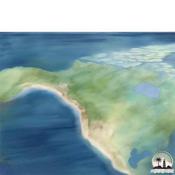
Welcome to Kayak, a Temperate island in the Gulf of Alaska, part of the majestic Pacific Ocean. This guide offers a comprehensive overview of what makes Kayak unique – from its geography and climate to its population, infrastructure, and beyond. Dive into the details:
Geography and size of Kayak
Size: 86.8 km²
Coastline: 150.8 km
Ocean: Pacific Ocean
Sea: Gulf of Alaska
Continent: North America
Kayak is a Medium Island spanning 87 km² with a coastline of 151 km.
Archipel: –
Tectonic Plate: North America – Covers North America and parts of the Atlantic and Arctic Oceans, characterized by diverse geological features and varying levels of seismic activity.
The geographic heart of the island is pinpointed at these coordinates:
Latitude: 59.94397275 / Longitude: -143.76015908
Climate and weather of Kayak
Climate Zone: Temperate
Climate Details: Subpolar Oceanic Climate
Temperature: Cold Summer
Climate Characteristics: Predominantly cold with cool summers and no dry season. Often found in coastal areas at higher latitudes or on islands.
Topography and nature of Kayak
Timezone: UTC-09:00
Timezone places: America/Anchorage
Max. Elevation: 335 m
Mean Elevation: 125 m
Vegetation: Deciduous Needleleaf Forest
Tree Coverage: 84%
The mean elevation is 125 m. The highest elevation on the island reaches approximately 335 meters above sea level. The island is characterized by Hills: Gently sloping landforms with rounded tops, having a maximum elevation between 200 and 500 meters. Hills contribute to a varied landscape on islands.
Dominating Vegetation: Deciduous Needleleaf Forest
Consists of needleleaf trees that shed their needles annually. This type of forest is less common and can be found in certain cold, northern regions. Kayak has a tree cover of 84 %.
Vegetation: 7 vegetation zones – Very Highly Diverse Island
Islands in this range are ecological powerhouses, showcasing a wide array of vegetation zones. Each zone, from lush rainforests to arid scrublands, coastal mangroves to mountainous regions, contributes to a complex and interdependent ecosystem. These islands are often hotspots of biodiversity, supporting numerous species and intricate ecological processes.
Infrastructure and Travelling to Kayak
Does the island have a public airport? no.
There is no public and scheduled airport on Kayak. The nearest airport is Whale Cove Airport, located 14 km away.
Does the island have a major port? no.
There are no major ports on Kayak. The closest major port is KATALLA, approximately 31 km away.
The mean population of Kayak is 0 per km². Kayak is Uninhabited. The island belongs to United States of America.
Continuing your journey, Karak is the next notable island, situated merely km away.
Kayak Island trip, Alaska Cub
Mostly inflight video of my Kayak Island and Icy Bay trip.Kayak Island trip, Alaska Cub
Mostly inflight video of my Kayak Island and Icy Bay trip.
Mostly inflight video of my Kayak Island and Icy Bay trip.
Kayak Island Lunch Break
This is a reminder to myself as much as everyone else; Spend time like ...
This is a reminder to myself as much as everyone else; Spend time like it's the most precious commodity there is. You can't but ...
Northern Exposures: Juneau to Kayak Island
This video describes the most exposed portion of our journey to Prince ...
This video describes the most exposed portion of our journey to Prince William Sound - across the Gulf of Alaska.
Going in a Crystal Kayak to Over Come Fear of Ocean
Northern Exposures: Kayak Island to Baranof Island
Homeward bound, after one month in Prince Edward Island, Venture heads ...
Homeward bound, after one month in Prince Edward Island, Venture heads south across the Gulf of Alaska and down the outside, ...
Kayak Island, Alaska
We had an amazing helicopter flight from Utah to Alaska, flying up the ...
We had an amazing helicopter flight from Utah to Alaska, flying up the coast of Canada, stopping at lighthouses along the way.
New Kayak, New Adventure - The Maine Island Trail - S4:E1
I think it is time to go on another adventure. I always like to ...
I think it is time to go on another adventure. I always like to experiment and see what works best for me. For this adventure I have a ...
Kayak Camping on a Remote Island for 2 Nights
We've kayaked and camped a lot of places but there's one that always ...
We've kayaked and camped a lot of places but there's one that always pulls us back. This time, we loaded up everything we could ...
Kalogeras Sisters KAYAK TO RACCOON ISLAND!
Welcome back guys!! OUR SOCIALS: Sunday: Snapchat: Kalogerassunday ...
Welcome back guys!! OUR SOCIALS: Sunday: Snapchat: Kalogerassunday TikTok: @sundaykalogeras Instagram: ...
Kayak - Hobie Tandem Island Rooftop Loader / Loading System / Hoist / Lifter - Part 1
Prototype tested with the help of David from Rod Bendings Inverloch. ...
Prototype tested with the help of David from Rod Bendings Inverloch. The loading onto the 4wd is a 4 step process. 1. Raise the ...
Would you like to sea kayak out to this island to camp for the night? #kayaking #seakayaking
On the west coast of Scotland while filming for our expedition skills ...
On the west coast of Scotland while filming for our expedition skills course.
My Own Island: Winter Kayak Camping On Loch Lomond
Come along with me for a bit of exploring around the islands in the ...
Come along with me for a bit of exploring around the islands in the south of Loch Lomond, followed by a couple of days of rather ...
Twin Island Guided Kayak Tour
Kayak to the "Mokes" Mokulua Islands on our kayak tour of Kailua Bay. ...
Kayak to the "Mokes" Mokulua Islands on our kayak tour of Kailua Bay. Snorkel in Lanikai, visit Queen's Bath, Kayak Surf and ...
Overnight on an Island in a $200 Walmart Kayak
Stopped at Walmart on my way north and picked up their cheapest kayak. ...
Stopped at Walmart on my way north and picked up their cheapest kayak. Took said kayak into the ocean and found a rather ...
Kayak Island Overnight (Hunting Bass in Lake of the Woods)
Its always fun to go try something new so we decided to do an ...
Its always fun to go try something new so we decided to do an overnight on an island but by means of a kayak. I was a bit skeptical ...
Rock island kayaking #kayak #whitewater #kayaking #adventure #nature #water
Kayaking the Aleutians: A 2,500km Adventure Through the Wild 🌊🛶🐻
Embark on an extraordinary expedition with explorers Justine Curgenven ...
Embark on an extraordinary expedition with explorers Justine Curgenven and Sarah Outen as they attempt to kayak the length of ...
Solo Kayak CAMPING | Overnight camp and cooking on an island
Join John on peaceful overnight solo kayak island camping trip on the ...
Join John on peaceful overnight solo kayak island camping trip on the serene Loch Maree. Having a camp and cook in a ...
Kayak Island Treasure Tour
Island Adventours - Kelley's Island.
Island Adventours - Kelley's Island.
Kayak Camping on Assateague Island.
My second multi-day trip to Assateague in Maryland. I highly recommend ...
My second multi-day trip to Assateague in Maryland. I highly recommend it. If you like this content you can support me by buying ...
Kayak Island - HD 1080p Video Sharing.mov
Japan Tsunami Debris on Kayak Island Alaska.
Japan Tsunami Debris on Kayak Island Alaska.
Island life in a sea kayak | Ep 3 - Bass by Kayak
Bass by Kayak follows Beau and a band of merry men across Australia's ...
Bass by Kayak follows Beau and a band of merry men across Australia's Bass Strait in a Sea Kayak. In Episode 3, seasickness, ...
Kayak Camping - 2 Days Island Living (Lake Ouachita)
Lisa and I spent 24 Hours on a remote island in the middle of Lake ...
Lisa and I spent 24 Hours on a remote island in the middle of Lake Ouachita, Arkansas. We were surrounded by mountains and ...
2 days of Kayak Fishing - Robben Island
Katonkel Ronkel 2025 – Day 1 & 2 Highlights ♂️ Launching from Three ...
Katonkel Ronkel 2025 – Day 1 & 2 Highlights ♂️ Launching from Three Anchor Bay and paddling out towards Robben ...
United States of America is classified as Developed region: G7: Group of Seven – Major advanced economies, including Canada, France, Germany, Italy, Japan, the United Kingdom, and the United States. The level of income is High income: OECD.
News – Latest Updates and Headlines from Kayak
Stay informed with the most recent news and important headlines from Kayak. Here’s a roundup of the latest developments.
Loading...
Please note: The data used here has been primarily extracted from satellite readings. Deviations from exact values may occur, particularly regarding the height of elevations and population density. Land area and coastline measurements refer to average values at mean high tide.