Kea
Welcome to Kea, a Temperate island in the Aegean Sea, part of the majestic Atlantic Ocean. This guide offers a comprehensive overview of what makes Kea unique – from its geography and climate to its population, infrastructure, and beyond. Dive into the details:
- Geography and Size: Explore the island’s size and location.
- Climate and Weather: Weather patterns and temperature.
- Topography and Nature: Uncover the natural wonders of the island.
- Infrastructure and Travelling: Insights on reaching, staying, and making the most of your visit.
- News and Headlines: Latest News.
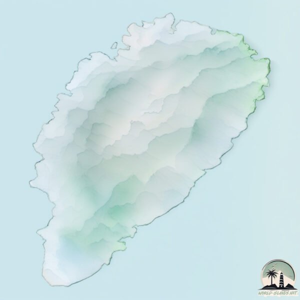
Geography and size of Kea
Size: 133.1 km²
Coastline: 81.5 km
Ocean: Atlantic Ocean
Sea: Aegean Sea
Continent: Europe
Kea is a Large Island spanning 133 km² with a coastline of 81 km.
Archipel: Cyclades – A group of islands in the Aegean Sea, part of Greece, known for their iconic white-washed architecture, beautiful beaches, and rich history.
Tectonic Plate: North America – Covers North America and parts of the Atlantic and Arctic Oceans, characterized by diverse geological features and varying levels of seismic activity.
The geographic heart of the island is pinpointed at these coordinates:
Latitude: 37.61286966 / Longitude: 24.33132509
Climate and weather of Kea
Climate Zone: Temperate
Climate Details: Hot-Summer Mediterranean Climate
Temperature: Hot Summer
Climate Characteristics: Characterized by hot, dry summers and mild, wet winters, typical of coastal areas with abundant sunshine.
Topography and nature of Kea
Timezone: UTC+02:00
Timezone places: Europe/Mariehamn
Max. Elevation: 496 m
Mean Elevation: 213 m
Vegetation: Agricultural Mosaic
Tree Coverage: 15%
The mean elevation is 213 m. The highest elevation on the island reaches approximately 496 meters above sea level. The island is characterized by Hills: Gently sloping landforms with rounded tops, having a maximum elevation between 200 and 500 meters. Hills contribute to a varied landscape on islands.
Dominating Vegetation: Agricultural Mosaic
A mix of cropland and natural vegetation, often seen in rural landscapes where agricultural fields are interspersed with patches of natural habitats. Kea has a tree cover of 15 %.
Vegetation: 11 vegetation zones – Exceptionally Diverse Island
Islands with more than ten vegetation zones are among the most ecologically rich and varied in the world. These islands are akin to miniature continents, boasting an incredible array of ecosystems. The sheer range of habitats, from high peaks to deep valleys, rainforests to deserts, creates a mosaic of life that is unparalleled. They are crucial for conservation and ecological studies.
Infrastructure and Travelling to Kea
Does the island have a public airport? no.
There is no public and scheduled airport on Kea. The nearest airport is Athens Eleftherios Venizelos International Airport, located 50 km away.
Does the island have a major port? no.
There are no major ports on Kea. The closest major port is LAVRIO, approximately 25 km away.
The mean population of Kea is 15 per km². Kea is Gently Populated. The island belongs to Greece.
Continuing your journey, Nisí Makrónisos is the next notable island, situated merely km away.
Island Kea (Tzia), Greece - by drone [4K]. #cyclades
![Island Kea (Tzia), Greece - by drone [4K]. #cyclades](https://i.ytimg.com/vi/IW6q-W1MOR0/mqdefault.jpg)
Greece is classified as Developed region: nonG7: Developed economies outside of the Group of Seven, characterized by high income and advanced economic structures. The level of income is High income: OECD.
News – Latest Updates and Headlines from Kea
Stay informed with the most recent news and important headlines from Kea. Here’s a roundup of the latest developments.
Please note: The data used here has been primarily extracted from satellite readings. Deviations from exact values may occur, particularly regarding the height of elevations and population density. Land area and coastline measurements refer to average values at mean high tide.