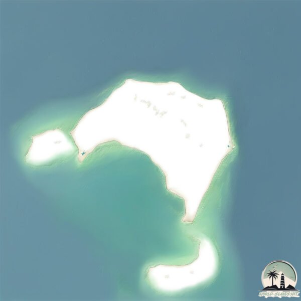
Welcome to Kebir, a Dry island in the Red Sea, part of the majestic Indian Ocean. This guide offers a comprehensive overview of what makes Kebir unique – from its geography and climate to its population, infrastructure, and beyond. Dive into the details:
Geography and size of Kebir
Size: 3.035 km²
Coastline: 8.6 km
Ocean: Indian Ocean
Sea: Red Sea
Continent: Africa
Kebir is a Small Island spanning 3 km² with a coastline of 8.6 km.
Archipel: –
Tectonic Plate: India – A major tectonic plate that initially moved northward at a rapid pace before colliding with the Eurasian Plate. This collision is responsible for the uplift of the Himalayas and the Tibetan Plateau.
The geographic heart of the island is pinpointed at these coordinates:
Latitude: 18.83102174 / Longitude: 38.16707953
Climate and weather of Kebir
Climate Zone: Dry
Climate Details: Hot Deserts Climate
Temperature: Hot
Climate Characteristics: Dominated by extremely hot temperatures, this climate is marked by minimal rainfall and barren landscapes. Nights often experience drastic temperature drops.
Topography and nature of Kebir
Timezone: UTC+03:00
Timezone places: Asia/Riyadh
Max. Elevation: 6 m
Mean Elevation: 1 m
Vegetation: Sparse Vegetation
Tree Coverage: 39%
The mean elevation is 1 m. The highest elevation on the island reaches approximately 6 meters above sea level. The island is characterized by Plains: Flat, low-lying lands characterized by a maximum elevation of up to 200 meters. On islands, plains are typically coastal lowlands or central flat areas.
Dominating Vegetation: Sparse Vegetation
These regions have limited plant growth, typically due to extreme conditions like aridity or poor soils. Vegetation is scattered and consists of hardy plant species. Kebir has a tree cover of 39 %.
Vegetation: 3 vegetation zones – Moderately Diverse Island
These islands start to show a broader range of ecological niches. With three vegetation zones, they may offer a mix of ecosystems like coastal areas, inland woods, and perhaps a distinct wetland or dry area. This diversity supports a wider range of flora and fauna, making these islands more ecologically complex than those with minimal diversity.
Infrastructure and Travelling to Kebir
Does the island have a public airport? no.
There is no public and scheduled airport on Kebir. The nearest airport is Port Sudan New International Airport, located 122 km away.
Does the island have a major port? no.
There are no major ports on Kebir. The closest major port is SAWAKIN HARBOR, approximately 95 km away.
The mean population of Kebir is 26 per km². Kebir is Gently Populated. The island belongs to Sudan.
Continuing your journey, Mukawwar is the next notable island, situated merely km away.
🌊 Discover Eritrea's Hidden Paradise: The Untouched Islands of the Red Sea 🌅 |Dahlak Archipelago 🌴✨
Eritrea #Travel #HiddenParadise #IslandAdventure #DahlakArchipelago #ExploreEritrea #TravelVlog #NatureLovers #RedSea ...🌊 Discover Eritrea's Hidden Paradise: The Untouched Islands of the Red Sea 🌅 |Dahlak Archipelago 🌴✨
Eritrea #Travel #HiddenParadise #IslandAdventure #DahlakArchipelago ...
Eritrea #Travel #HiddenParadise #IslandAdventure #DahlakArchipelago #ExploreEritrea #TravelVlog #NatureLovers #RedSea ...
Eritrea’s Hidden Paradise: The Dahlak Islands You’ve Never Seen
Discover the enchanting Dahlak Islands, Eritrea's hidden treasure ...
Discover the enchanting Dahlak Islands, Eritrea's hidden treasure nestled in the heart of the Red Sea! ✨ This cinematic journey ...
ERITREA - Returning to Dissei Island (4K) Fishing & Snorkeling @ Eritrean Red Sea and Dahlak Islands
I return to Eritrea, exploring the serene beauty of Dissei Island and ...
I return to Eritrea, exploring the serene beauty of Dissei Island and its pristine underwater world. Discover unique peace and ...
Eritrean Animation Dahlak Island Coconut (ኮኮናት) 2021
Guys Subscribe to my YouTube channel for more crazy videos ✊ More out ...
Guys Subscribe to my YouTube channel for more crazy videos ✊ More out soon Vlogs & Prank Engagement, Birthday ...
💋 #diana #shorts #tiktok #nastya #boyfriend
Dahlak Archipelago: Yemen's Foothold in Eritrea?
Eritrea has 350+ islands and more than 100 of them can be found in the ...
Eritrea has 350+ islands and more than 100 of them can be found in the Dahlak Archipelago. Located some 36 miles off the ...
Disei island, Dahlak Archipelago, Eritrea
By boat, dropped off at a settlement on Disei Island in the Dahlak ...
By boat, dropped off at a settlement on Disei Island in the Dahlak Archipelago. Eritrea.
Eritrea Dahlak Islands Sun ☀ Set Drone Footage !
Massawa, the pearl of the red sea and God bless Eritrea for over 370 ...
Massawa, the pearl of the red sea and God bless Eritrea for over 370 islands. ክንደይ ይፍተውኻ ጻሓይ ክትዓርብ ከላ ኣብ ...
🩰 #diana #shorts #tiktok #boyfriend
ሌላ ምስ ደሴት ዳህላክ - ፍሉይ መደብ ብምኽንያት በዓል ልደት | Dahlak Island | ERi-TV
ERi-TV, Eritrea - ሌላ ምስ ደሴት ዳህላክ - ፍሉይ መደብ ብምኽንያት በዓል ልደት | Dahlak ...
ERi-TV, Eritrea - ሌላ ምስ ደሴት ዳህላክ - ፍሉይ መደብ ብምኽንያት በዓል ልደት | Dahlak Island ERi-TV, Eritrea - No part of ...
Eritrea Red sea 🇪🇷💕❤️#eritrea #eritrean #eritreanmusic
Kerguelen Islands: The Remote Desolation Islands 🏞️🦭
What if I told you there's an island group so remote it's often called ...
What if I told you there's an island group so remote it's often called the “Desolation Islands”? Welcome to Hidden Island Secrets.
ERITREA Dahlak Islands
Boat ride from Massawa Port to Dissei Island in the Dahlak Islands ...
Boat ride from Massawa Port to Dissei Island in the Dahlak Islands archipelago. Visit the beaches near the campsite. Snorkel in ...
Eritrean Island -Dahlak
"New Eritrean Film" #eritrean #film "Ethiopian music' #eritreanguayla ...
"New Eritrean Film" #eritrean #film "Ethiopian music' #eritreanguayla #Tigrinamusic #ethiopianmusic #eritreanmovie ...
Visiting fishermen's village on Dissei island in Eritrean Red Sea #redsea #eritrea #disseiisland
Great visit to fishermen's village on Dissei island GEAR I use a ...
Great visit to fishermen's village on Dissei island GEAR I use a variety of gear for all my videos: GoPro 12 Sony a7RV Sony ZV ...
He is eating nothing 😂 | squid games
squid game, squid game episode 1, squid game trailer, squid game song, ...
squid game, squid game episode 1, squid game trailer, squid game song, squid game episode 1 مترجم, squid game مترجم, squid ...
SOCOTRA: the most beautiful place in the world #traveler #socotra #yemen #worldtravel #nature
06 Gamul Kebir.wmv
Gamul Kebir, ook wel gekscherend "de Grote Kamelenbult" genoemd, ligt ...
Gamul Kebir, ook wel gekscherend "de Grote Kamelenbult" genoemd, ligt niet ver van de marina waarvan de Dory, de boot van ...
Eritrean Red Sea - 4K Drone View 🇪🇷 with calm instrumental eritrean music ⏐ Massawa, Green Island
Eritrea has the sixth longest coastline in Africa measuring 2234 ...
Eritrea has the sixth longest coastline in Africa measuring 2234 kilometers long. It is situated to the northeast of the african ...
Red Sea: One of 350 islands in Eritrea 🇪🇷
Djerba, Tunisia: Discover the Mediterranean’s North African Gem! 🏝️✨
Did you know there's a North African island where whitewashed villages ...
Did you know there's a North African island where whitewashed villages meet turquoise waters and centuries-old traditions blend ...
20251216 Siyul Kebir
Plongée en Mer Rouge.
Plongée en Mer Rouge.
Eritrea- Massawa Drone footage near Dahlak Hotel
Massawa is full of history! Outside of the beautiful beach and ...
Massawa is full of history! Outside of the beautiful beach and inhabited islands nearby, this place was a battleground between ...
Sudan is classified as Developing region: Regions characterized by lower income levels, with economies in the process of industrialization and modernization. The level of income is Lower middle income.
News – Latest Updates and Headlines from Kebir
Stay informed with the most recent news and important headlines from Kebir. Here’s a roundup of the latest developments.
Loading...
Please note: The data used here has been primarily extracted from satellite readings. Deviations from exact values may occur, particularly regarding the height of elevations and population density. Land area and coastline measurements refer to average values at mean high tide.