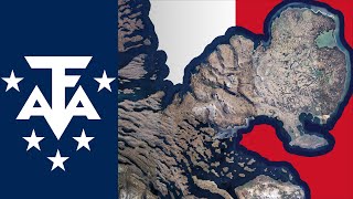
Kerguelen
Welcome to Kerguelen, a Polar island in the Indian Ocean, part of the majestic Indian Ocean. This guide offers a comprehensive overview of what makes Kerguelen unique – from its geography and climate to its population, infrastructure, and beyond. Dive into the details:
- Geography and Size: Explore the island’s size and location.
- Climate and Weather: Weather patterns and temperature.
- Topography and Nature: Uncover the natural wonders of the island.
- Infrastructure and Travelling: Insights on reaching, staying, and making the most of your visit.
- News and Headlines: Latest News.
Geography and size of Kerguelen
Size: 6576 km²
Coastline: 2594 km
Ocean: Indian Ocean
Sea: Indian Ocean
Continent: Seven seas (open ocean)
Kerguelen is a Very Large Island spanning 6576 km² with a coastline of 2594 km.
Archipel: Kerguelen Islands – A group of islands in the southern Indian Ocean, often referred to as the “Desolation Islands,” known for their isolation and harsh environment.
Tectonic Plate: Antarctica – Covers the Antarctic continent and extends outward, characterized by interactions with surrounding oceanic plates and known for its seismic activity along the periphery.
The geographic heart of the island is pinpointed at these coordinates:
Latitude: -49.31585608 / Longitude: 69.49572022
Climate and weather of Kerguelen
Climate Zone: Polar
Climate Details: Tundra
Temperature: Cold
Climate Characteristics: The tundra climate features long, extremely cold winters and short, cool summers. Vegetation is limited to mosses, lichens, and small shrubs due to the low temperatures and short growing seasons. Biodiversity is low, but some specialized species thrive.
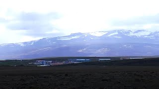
Topography and nature of Kerguelen
Timezone: UTC+05:00
Timezone places: Asia/Karachi
Max. Elevation: 1850 m Mont Ross
Mean Elevation: 266 m
Vegetation: Herbaceous Cover
Tree Coverage: 14%
The mean elevation is 266 m. Dominating the island’s landscape, the majestic “Mont Ross” rises as the highest peak, soaring to impressive heights. The island is characterized by Plateau: Elevated flatlands rising sharply above the surrounding area, with a maximum elevation over 500 meters but a mean elevation less than 300 meters, forming unique highland areas on islands.
Dominating Vegetation: Herbaceous Cover
Comprising mainly of grasses, herbs, and ferns, these areas are common in prairies, meadows, and savannas, and can vary widely in species composition. Kerguelen has a tree cover of 14 %.
Vegetation: 14 vegetation zones – Exceptionally Diverse Island
Islands with more than ten vegetation zones are among the most ecologically rich and varied in the world. These islands are akin to miniature continents, boasting an incredible array of ecosystems. The sheer range of habitats, from high peaks to deep valleys, rainforests to deserts, creates a mosaic of life that is unparalleled. They are crucial for conservation and ecological studies.
Infrastructure and Travelling to Kerguelen
Does the island have a public airport? no.
There is no public and scheduled airport on Kerguelen. The nearest airport is Sir Charles Gaetan Duval Airport, located 3272 km away.
Does the island have a major port? no.
There are no major ports on Kerguelen. The closest major port is PORT MATHURIN, approximately 3279 km away.
The mean population of Kerguelen is per km². Kerguelen is . The island belongs to France.
Continuing your journey, Rennes is the next notable island, situated merely km away.
The Kerguelen Islands | France's Antarctic Archipelago

France is classified as Developed region: G7: Group of Seven – Major advanced economies, including Canada, France, Germany, Italy, Japan, the United Kingdom, and the United States. The level of income is High income: OECD.
News – Latest Updates and Headlines from Kerguelen
Stay informed with the most recent news and important headlines from Kerguelen. Here’s a roundup of the latest developments.
Social Media Posts about Kerguelen
Please note: The data used here has been primarily extracted from satellite readings. Deviations from exact values may occur, particularly regarding the height of elevations and population density. Land area and coastline measurements refer to average values at mean high tide.