Khram Yai
Welcome to Khram Yai, a Tropical island in the Gulf of Thailand, part of the majestic Pacific Ocean. This guide offers a comprehensive overview of what makes Khram Yai unique – from its geography and climate to its population, infrastructure, and beyond. Dive into the details:
- Geography and Size: Explore the island’s size and location.
- Climate and Weather: Weather patterns and temperature.
- Topography and Nature: Uncover the natural wonders of the island.
- Infrastructure and Travelling: Insights on reaching, staying, and making the most of your visit.
- News and Headlines: Latest News.
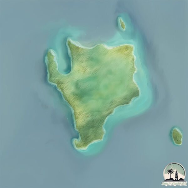
Geography and size of Khram Yai
Size: 14 km²
Coastline: 21.1 km
Ocean: Pacific Ocean
Sea: Gulf of Thailand
Continent: Asia
Khram Yai is a Medium Island spanning 14 km² with a coastline of 21 km.
Archipel: –
Tectonic Plate: Sunda – Extends across Southeast Asia, encompassing parts of the Sunda Shelf, known for its interaction with the Australian Plate, contributing to volcanic activity in Indonesia.
The geographic heart of the island is pinpointed at these coordinates:
Latitude: 12.69945237 / Longitude: 100.78636832
Climate and weather of Khram Yai
Climate Zone: Tropical
Climate Details: Tropical Savanna, Wet
Temperature: Hot
Climate Characteristics: Defined by distinct wet and dry seasons with high temperatures year-round. Pronounced rainfall occurs during the wet season, while the dry season is marked by drought.
Topography and nature of Khram Yai
Timezone: UTC+07:00
Timezone places: Asia/Jakarta
Max. Elevation: 114 m
Mean Elevation: 59 m
Vegetation: Evergreen Broadleaf Forest
Tree Coverage: 57%
The mean elevation is 59 m. The highest elevation on the island reaches approximately 114 meters above sea level. The island is characterized by Plains: Flat, low-lying lands characterized by a maximum elevation of up to 200 meters. On islands, plains are typically coastal lowlands or central flat areas.
Dominating Vegetation: Evergreen Broadleaf Forest
Characterized by dense, lush canopies of broadleaf trees that retain their leaves year-round. These forests are typically found in tropical and subtropical regions and are known for their high biodiversity. Khram Yai has a tree cover of 57 %.
Vegetation: 7 vegetation zones – Very Highly Diverse Island
Islands in this range are ecological powerhouses, showcasing a wide array of vegetation zones. Each zone, from lush rainforests to arid scrublands, coastal mangroves to mountainous regions, contributes to a complex and interdependent ecosystem. These islands are often hotspots of biodiversity, supporting numerous species and intricate ecological processes.
Infrastructure and Travelling to Khram Yai
Does the island have a public airport? no.
There is no public and scheduled airport on Khram Yai. The nearest airport is U-Tapao International Airport, located 22 km away.
Does the island have a major port? no.
There are no major ports on Khram Yai. The closest major port is SATTAHIP, approximately 15 km away.
The mean population of Khram Yai is 867 per km². Khram Yai is Densely Populated. The island belongs to Thailand.
Continuing your journey, Koh Chang is the next notable island, situated merely km away.
Koh Khram Noi The Best Little Island of Pattaya 😍 #viral #trending #shorts


Thailand is classified as Emerging region: G20: Group of Twenty – Major economies comprising both developed and emerging countries, representing the world’s largest economies. The level of income is Upper middle income.
News – Latest Updates and Headlines from Khram Yai
Stay informed with the most recent news and important headlines from Khram Yai. Here’s a roundup of the latest developments.
- These 20 Thai Islands Will Change How You Vacation Forever - Travel2Nexton 10 November 2025
These 20 Thai Islands Will Change How You Vacation Forever Travel2Next
- Night Beats debuts "Behind The Green Door" - Northern Transmissionson 16 March 2025
Night Beats debuts "Behind The Green Door" Northern Transmissions
- Incredible Islands in Thailand - The Times of Indiaon 9 March 2023
Incredible Islands in Thailand The Times of India
- Thailand islands for your bucket list - The Times of Indiaon 4 January 2023
Thailand islands for your bucket list The Times of India
- Pattaya yacht runs aground off Koh Khram Yai island - Pattaya Mailon 16 November 2022
Pattaya yacht runs aground off Koh Khram Yai island Pattaya Mail
- Ban Ko Khram, Chon Buri, Thailand Weather Forecast - AccuWeatheron 27 July 2017
Ban Ko Khram, Chon Buri, Thailand Weather Forecast AccuWeather
Please note: The data used here has been primarily extracted from satellite readings. Deviations from exact values may occur, particularly regarding the height of elevations and population density. Land area and coastline measurements refer to average values at mean high tide.