Kianoni Island
Welcome to Kianoni Island, a Tropical island in the Indian Ocean, part of the majestic Indian Ocean. This guide offers a comprehensive overview of what makes Kianoni Island unique – from its geography and climate to its population, infrastructure, and beyond. Dive into the details:
- Geography and Size: Explore the island’s size and location.
- Climate and Weather: Weather patterns and temperature.
- Topography and Nature: Uncover the natural wonders of the island.
- Infrastructure and Travelling: Insights on reaching, staying, and making the most of your visit.
- News and Headlines: Latest News.
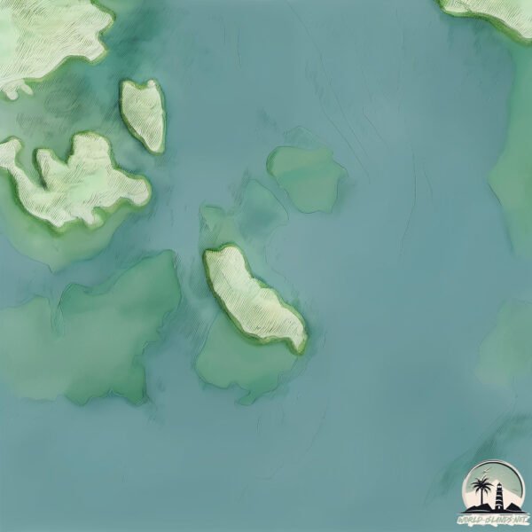
Geography and size of Kianoni Island
Size: 7.41 km²
Coastline: 23.6 km
Ocean: Indian Ocean
Sea: Indian Ocean
Continent: Africa
Kianoni Island is a Small Island spanning 7.4 km² with a coastline of 23.6 km.
Archipel: –
Tectonic Plate: North Bismarck – Located north of New Guinea, it’s involved in complex tectonic interactions with the Pacific and South Bismarck plates, contributing to seismic activity in the region.
The geographic heart of the island is pinpointed at these coordinates:
Latitude: -2.00633863 / Longitude: 41.2077881
Climate and weather of Kianoni Island
Climate Zone: Tropical
Climate Details: Tropical Savanna, Wet
Temperature: Hot
Climate Characteristics: Defined by distinct wet and dry seasons with high temperatures year-round. Pronounced rainfall occurs during the wet season, while the dry season is marked by drought.
Topography and nature of Kianoni Island
Timezone: UTC+03:00
Timezone places: Asia/Riyadh
Max. Elevation: 6 m
Mean Elevation: 3 m
Vegetation: Mangrove Forest
Tree Coverage: 83%
The mean elevation is 3 m. The highest elevation on the island reaches approximately 6 meters above sea level. The island is characterized by Plains: Flat, low-lying lands characterized by a maximum elevation of up to 200 meters. On islands, plains are typically coastal lowlands or central flat areas.
Dominating Vegetation: Mangrove Forest
Found in coastal areas and river deltas, these unique wetland ecosystems are adapted to saline conditions and are crucial for coastal protection and biodiversity. Kianoni Island has a tree cover of 83 %.
Vegetation: 6 vegetation zones – Very Highly Diverse Island
Islands in this range are ecological powerhouses, showcasing a wide array of vegetation zones. Each zone, from lush rainforests to arid scrublands, coastal mangroves to mountainous regions, contributes to a complex and interdependent ecosystem. These islands are often hotspots of biodiversity, supporting numerous species and intricate ecological processes.
Infrastructure and Travelling to Kianoni Island
Does the island have a public airport? no.
There is no public and scheduled airport on Kianoni Island. The nearest airport is Kiwayu Airport, located 9 km away.
Does the island have a major port? no.
There are no major ports on Kianoni Island. The closest major port is LAMU, approximately 43 km away.
The mean population of Kianoni Island is 71 per km². Kianoni Island is Gently Populated. The island belongs to Somalia.
Continuing your journey, Uvondo Island is the next notable island, situated merely km away.
canion island ।। a true haven on earth ।। the wonders.


Somalia is classified as Emerging region: G20: Group of Twenty – Major economies comprising both developed and emerging countries, representing the world’s largest economies. The level of income is Low income.
News – Latest Updates and Headlines from Kianoni Island
Stay informed with the most recent news and important headlines from Kianoni Island. Here’s a roundup of the latest developments.
Please note: The data used here has been primarily extracted from satellite readings. Deviations from exact values may occur, particularly regarding the height of elevations and population density. Land area and coastline measurements refer to average values at mean high tide.