Kiebu
Welcome to Kiebu, a Tropical island in the South Pacific Ocean, part of the majestic Pacific Ocean. This guide offers a comprehensive overview of what makes Kiebu unique – from its geography and climate to its population, infrastructure, and beyond. Dive into the details:
- Geography and Size: Explore the island’s size and location.
- Climate and Weather: Weather patterns and temperature.
- Topography and Nature: Uncover the natural wonders of the island.
- Infrastructure and Travelling: Insights on reaching, staying, and making the most of your visit.
- News and Headlines: Latest News.
Geography and size of Kiebu
Size: 0.909 km²
Coastline: 5.5 km
Ocean: Pacific Ocean
Sea: South Pacific Ocean
Continent: Oceania
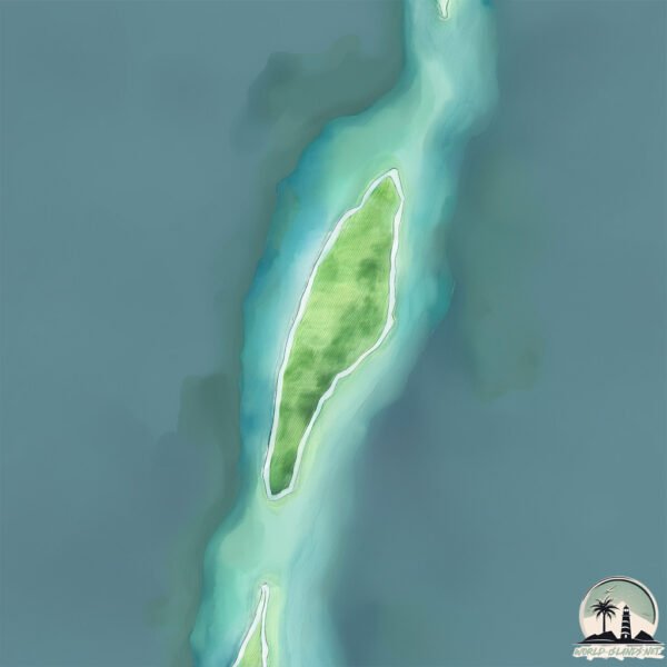
Kiebu is a Tiny Island spanning 0.909 km² with a coastline of 5.5 km.
Archipel: Kiribati – An island nation in the central Pacific Ocean, comprising 33 atolls and reef islands, known for their vibrant culture and significant challenges due to climate change.
Tectonic Plate: Pacific – The world’s largest tectonic plate, covering much of the Pacific Ocean, known for the Pacific Ring of Fire with extensive seismic and volcanic activity.
The geographic heart of the island is pinpointed at these coordinates:
Latitude: 3.32099818 / Longitude: 172.97518874
Climate and weather of Kiebu
Climate Zone: Tropical
Climate Details: Tropical Rainforest Climate
Temperature: Hot
Climate Characteristics: This climate is typified by heavy rainfall throughout the year, high humidity, and consistently high temperatures, leading to lush rainforests and rich biodiversity. Seasonal temperature variations are minimal.
Topography and nature of Kiebu
Timezone: UTC+12:00
Timezone places: Pacific/Auckland
Max. Elevation: 1 m
Mean Elevation: -9 m
Vegetation: Sparse Vegetation
Tree Coverage: 94%
The mean elevation is -9 m. The highest elevation on the island reaches approximately 1 meters above sea level. The island is characterized by Plains: Flat, low-lying lands characterized by a maximum elevation of up to 200 meters. On islands, plains are typically coastal lowlands or central flat areas.
Dominating Vegetation: Sparse Vegetation
These regions have limited plant growth, typically due to extreme conditions like aridity or poor soils. Vegetation is scattered and consists of hardy plant species. Kiebu has a tree cover of 94 %.
Vegetation: 1 vegetation zones – Minimal Diversity Island
These islands exhibit the most basic level of ecological diversity, often characterized by a single dominant vegetation type. This could be due to extreme environmental conditions, limited land area, or significant human impact. They represent unique ecosystems where specific species have adapted to thrive in these singular environments.
Infrastructure and Travelling to Kiebu
Does the island have a public airport? no.
There is no public and scheduled airport on Kiebu. The nearest airport is Butaritari Airport, located 31 km away.
Does the island have a major port? no.
There are no major ports on Kiebu. The closest major port is TARAWA ATOLL, approximately 220 km away.
The mean population of Kiebu is 253 per km². Kiebu is Moderately Inhabited. The island belongs to Kiribati.
Continuing your journey, Temanokunuea is the next notable island, situated merely km away.
MAKIN ISLAND KIRIBATI


Kiribati is classified as Least developed region: Countries that exhibit the lowest indicators of socioeconomic development, with the lowest Human Development Index ratings. The level of income is Lower middle income.
News – Latest Updates and Headlines from Kiebu
Stay informed with the most recent news and important headlines from Kiebu. Here’s a roundup of the latest developments.
Please note: The data used here has been primarily extracted from satellite readings. Deviations from exact values may occur, particularly regarding the height of elevations and population density. Land area and coastline measurements refer to average values at mean high tide.