Kiltān Island
Welcome to Kiltān Island, a Tropical island in the Laccadive Sea, part of the majestic Indian Ocean. This guide offers a comprehensive overview of what makes Kiltān Island unique – from its geography and climate to its population, infrastructure, and beyond. Dive into the details:
- Geography and Size: Explore the island’s size and location.
- Climate and Weather: Weather patterns and temperature.
- Topography and Nature: Uncover the natural wonders of the island.
- Infrastructure and Travelling: Insights on reaching, staying, and making the most of your visit.
- News and Headlines: Latest News.
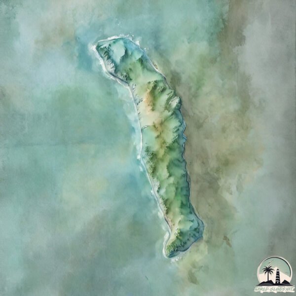
Geography and size of Kiltān Island
Size: 1.733 km²
Coastline: 8.5 km
Ocean: Indian Ocean
Sea: Laccadive Sea
Continent: Seven seas (open ocean)
Kiltān Island is a Small Island spanning 1.7 km² with a coastline of 8.5 km.
Archipel: Laccadive Islands – Also known as Lakshadweep, a group of islands off the southwestern coast of India, known for their pristine beauty and coral reefs.
Tectonic Plate: Burma – Also known as the Burma Plate, it’s a minor tectonic plate in Southeast Asia, largely covering Burma (Myanmar) and parts of the Indian Ocean. It’s involved in the subduction process under the Eurasian Plate, contributing to seismic activity in the region.
The geographic heart of the island is pinpointed at these coordinates:
Latitude: 11.48382436 / Longitude: 73.00574499
Climate and weather of Kiltān Island
Climate Zone: Tropical
Climate Details: Tropical Monsoon Climate
Temperature: Hot
Climate Characteristics: Characterized by heavy rainfall, high humidity, and uniformly high temperatures, but with a distinct short dry season. It features a seasonal reversal of prevailing wind directions.
Topography and nature of Kiltān Island
Timezone: UTC+05:30
Timezone places:
Max. Elevation: -8 m
Mean Elevation: -41 m
Vegetation: Evergreen Needleleaf Forest
Tree Coverage: 34%
The mean elevation is -41 m. Remarkably, this unique island barely emerges above the sea level, showcasing nature’s fascinating interplay with the ocean. The island is characterized by Plains: Flat, low-lying lands characterized by a maximum elevation of up to 200 meters. On islands, plains are typically coastal lowlands or central flat areas.
Dominating Vegetation: Evergreen Needleleaf Forest
Dominated by evergreen coniferous trees such as pines and firs, which retain their needle-like leaves throughout the year. These forests are often found in cooler climates. Kiltān Island has a tree cover of 34 %.
Vegetation: 4 vegetation zones – Diverse Island
Four distinct vegetation zones mark these islands as ecologically diverse. They might feature varied landscapes such as forests, beaches, grasslands, and rocky areas. Such diversity reflects the island’s complex ecological interactions and varied habitats, which can support a rich array of wildlife and plant species.
Infrastructure and Travelling to Kiltān Island
Does the island have a public airport? no.
There is no public and scheduled airport on Kiltān Island. The nearest airport is Agatti Airport, located 117 km away.
Does the island have a major port? no.
There are no major ports on Kiltān Island. The closest major port is NEW MANGALORE, approximately 256 km away.
The mean population of Kiltān Island is 2108 per km². Kiltān Island is Densely Populated. The island belongs to India.
Continuing your journey, Ramanthali is the next notable island, situated merely km away.
𝙆𝙄𝙇𝙏𝘼𝙉 𝙄𝙎𝙇𝘼𝙉𝘿 2019 ഈദ് 𝙨𝙥𝙖𝙘𝙞𝙖𝙡...✨🌟🌠


India is classified as Emerging region: BRIC: Brazil, Russia, India, and China – Economies noted for their rapid growth and increasing influence on global affairs. The level of income is Lower middle income.
News – Latest Updates and Headlines from Kiltān Island
Stay informed with the most recent news and important headlines from Kiltān Island. Here’s a roundup of the latest developments.
- Valiyaparamba: Sandwiched between backwaters & sea, and hammered by CRZ rules - The New Indian Expressby "Ramanthali island" - Google News on 25 August 2022
Valiyaparamba: Sandwiched between backwaters & sea, and hammered by CRZ rules The New Indian Express
Please note: The data used here has been primarily extracted from satellite readings. Deviations from exact values may occur, particularly regarding the height of elevations and population density. Land area and coastline measurements refer to average values at mean high tide.