Welcome to King, a Temperate island in the Bass Strait, part of the majestic Pacific Ocean. This guide offers a comprehensive overview of what makes King unique – from its geography and climate to its population, infrastructure, and beyond. Dive into the details:
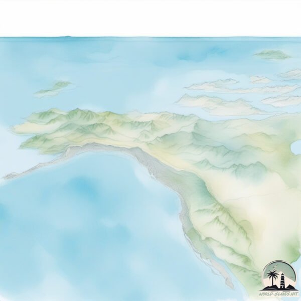
Geography and size of King
Size: 1.935 km²
Coastline: 9.2 km
Ocean: Pacific Ocean
Sea: Bass Strait
Continent: Oceania
King is a Small Island spanning 1.9 km² with a coastline of 9.2 km.
Archipel: –
Tectonic Plate: Australia – A major tectonic plate covering Australia, New Zealand, and parts of the Indian and Pacific Oceans, known for its relative stability and occasional seismic activity.
The geographic heart of the island is pinpointed at these coordinates:
Latitude: -39.82853392 / Longitude: 143.98571261
Climate and weather of King
Climate Zone: Temperate
Climate Details: Warm-Summer Mediterranean Climate
Temperature: Warm Summer
Climate Characteristics: Characterized by warm, dry summers and mild, wet winters, typical of coastal areas with abundant sunshine Rain is more common in the winter months, maintaining a moderate climate.
Topography and nature of King
Timezone: UTC+10:00
Timezone places: Australia/Sydney
Max. Elevation: 146 m
Mean Elevation: 54 m
Vegetation: Cultivated Land
Tree Coverage: 28%
The mean elevation is 54 m. The highest elevation on the island reaches approximately 146 meters above sea level. The island is characterized by Plains: Flat, low-lying lands characterized by a maximum elevation of up to 200 meters. On islands, plains are typically coastal lowlands or central flat areas.
Dominating Vegetation: Cultivated Land
Areas dedicated to agricultural activities, growing crops like grains, vegetables, and fruits. These lands are usually human-modified landscapes. King has a tree cover of 28 %.
Vegetation: 11 vegetation zones – Exceptionally Diverse Island
Islands with more than ten vegetation zones are among the most ecologically rich and varied in the world. These islands are akin to miniature continents, boasting an incredible array of ecosystems. The sheer range of habitats, from high peaks to deep valleys, rainforests to deserts, creates a mosaic of life that is unparalleled. They are crucial for conservation and ecological studies.
Infrastructure and Travelling to King
Does the island have a public airport? yes.
King has a public and scheduled airport. The following airports are located on this island: King Island Airport.
Does the island have a major port? no.
There are no major ports on King. The closest major port is CAPE FLATTERY HARBOR, approximately 147 km away.
The mean population of King is 1 per km². King is Gently Populated. The island belongs to Australia.
The name of the island resonates across different cultures and languages. Here is how it is known around the world: Arabic: جزيرة كينج ايسلند; German: King Island; Spanish: Isla King; French: île King; Portuguese: Ilha King; Russian: Кинг; Chinese: 金岛
Continuing your journey, Hunter is the next notable island, situated merely km away.
King Island
We flew from Moorabbin airport, in Melbourne's south across Bass Strait to the tiny King Island for a short visit. King Island is well ...King Island
We flew from Moorabbin airport, in Melbourne's south across Bass ...
We flew from Moorabbin airport, in Melbourne's south across Bass Strait to the tiny King Island for a short visit. King Island is well ...
Kings Island Review | A Gold Standard for Amusement Parks | Mason, Ohio
One of America's most visited amusement parks sits just outside of ...
One of America's most visited amusement parks sits just outside of Cincinnati, Ohio, housing a very impressive collection of roller ...
Kings Island First Drop POVs
Credits: Kings Island HockeyGUY66871.
Credits: Kings Island HockeyGUY66871.
Diamondback Roller Coaster (POV) - 4K Cinematic Series Kings Island
You're all clear to slither up, down and all around Rivertown on our ...
You're all clear to slither up, down and all around Rivertown on our new front row POV of Diamondback! Check it out: ...
USA Road Trip: Kings Island 🇺🇸
Kings Island Orion Roller Coaster POV
Want to ride Orion in real life? Ride it all season long with a season ...
Everything I Rode at KINGS ISLAND 🗼🎢
My Theme Park STRATEGY GUIDE: Available Now ⬇️ ...
DJ Noiz & Tenelle - Island King (Remix) ft. Spawnbreezie, Kennyon Brown, Rellek Brown (Lyric Video)
Official Lyric Video by DJ Noiz @DJNoiz & @Tenelle for Island King ...
Official Lyric Video by DJ Noiz @DJNoiz & @Tenelle for Island King (Remix) featuring @spawnbreezie @KennyonBrown ...
Banshee at Kings Island POV
Riders will scream their way through 4124 feet of track and seven ...
Riders will scream their way through 4124 feet of track and seven stomach-churning inversions at speeds up to 68 mph on the ...
Kings Island Vlog June 2023
Join us for a visit to Kings Island in Ohio, the 17th theme park of ...
Join us for a visit to Kings Island in Ohio, the 17th theme park of our USA Road Trip! In this action packed vlog we experience all of ...
Kings Island - Light Work, No Reaction... #shorts
SUBSCRIBE to our channel for more official Kings Island content! Get ...
SUBSCRIBE to our channel for more official Kings Island content! Get the best deal on tickets to Kings Island HERE: ...
The Roller Coasters of Kings Island: RANKED
Kings Island continues to prove itself as one of America's best ...
Kings Island continues to prove itself as one of America's best amusement parks, with one of the most well rounded roller coaster ...
The Beast POV first hill at Kings Island #thebeast #kingsisland #pov #woodenrollercoaster
Kings Island - #NationalRollerCoasterDay 2025
It's National Roller Coaster Day! Celebrate with a 2026 Gold Pass and ...
It's National Roller Coaster Day! Celebrate with a 2026 Gold Pass and get access to 40+ parks But hurry, price increases 9/2 ...
Every Roller Coaster at Kings Island! (2025 Edition)
Today I bring in every single roller coaster at one of the most ...
Today I bring in every single roller coaster at one of the most popular amusement parks in the world - Kings Island in Mason, Ohio!
Mystic Timbers Roller Coaster (POV) - 4K Cinematic Series Kings Island
Everyone who enjoys the fun and thrills of riding a roller coaster ...
Everyone who enjoys the fun and thrills of riding a roller coaster will want to experience Mystic Timbers, voted “Best New Ride” in ...
TOP 15 KING ISLAND (TAS) Attractions (Things to Do & See)
Best places to visit in King Island - Tasmania Getyourguide: Tasmania ...
The Beast Roller Coaster (POV) - 4K Cinematic Series Kings Island
Take a ride on The Beast – a haunting, lurking monster that knows no ...
Take a ride on The Beast – a haunting, lurking monster that knows no master! #KingsIsland #TheBeast #rollercoasters ...
Our King Island
King island is a small island situated between Victoria and Tasmania. ...
King island is a small island situated between Victoria and Tasmania. It's a lovely little place with great people, beaches and ...
Kings Island - Introducing Phantom Theater: Opening Nightmare
"So…you wanted to see the theater, did ya?" The curtain is set to rise ...
"So…you wanted to see the theater, did ya?" The curtain is set to rise on Kings Island's all-new Phantom Theater: Opening ...
I went back to KINGS ISLAND 🗼🎢
SHOP at United States of Amusement – An Apparel Brand Built for Thrill ...
Adventure Express Roller Coaster (POV) - 4K Cinematic Series Kings Island
Experience an exciting excursion with Adventure Express, a tour ...
Experience an exciting excursion with Adventure Express, a tour company run by Arrow Cargo Co. Our tour takes you through the ...
Tassie Tourism Ambassador Program - King Island
King Island, part of the state of Tasmania, is a remote and ...
King Island, part of the state of Tasmania, is a remote and picturesque island situated in the Bass Strait between mainland ...
A Day In The Life On King Island | Discover Tasmania
A typical day on King Island couldn't feel further from the rat race. ...
A typical day on King Island couldn't feel further from the rat race. Ready to kick the pace down a notch? Just ask the island's local ...
King Island farmers prepare for a future once unimaginable | Landline | ABC Australia
The farmers on Australia's King Island in the Bass Strait are ...
The farmers on Australia's King Island in the Bass Strait are preparing for a future once unimaginable... one which factors in ...
Australia is classified as Developed region: nonG7: Developed economies outside of the Group of Seven, characterized by high income and advanced economic structures. The level of income is High income: OECD.
News – Latest Updates and Headlines from King
Stay informed with the most recent news and important headlines from King. Here’s a roundup of the latest developments.
Loading...
Please note: The data used here has been primarily extracted from satellite readings. Deviations from exact values may occur, particularly regarding the height of elevations and population density. Land area and coastline measurements refer to average values at mean high tide.