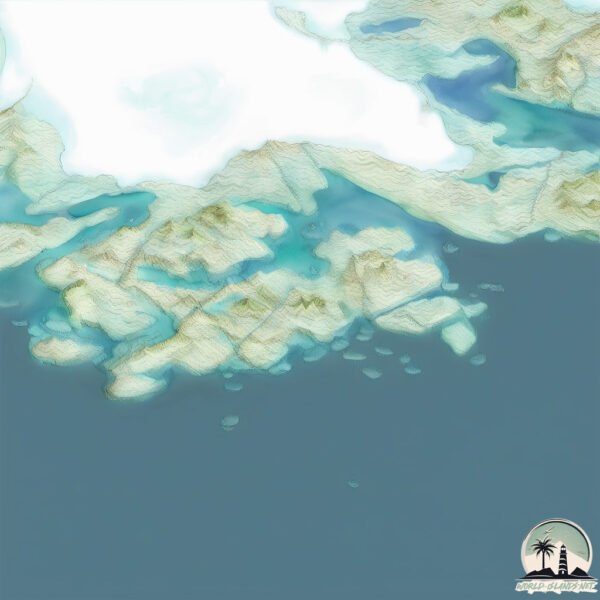
Welcome to Kitak, a Polar island in the North Atlantic Ocean, part of the majestic Atlantic Ocean. This guide offers a comprehensive overview of what makes Kitak unique – from its geography and climate to its population, infrastructure, and beyond. Dive into the details:
Geography and size of Kitak
Size: 35.9 km²
Coastline: 67.9 km
Ocean: Atlantic Ocean
Sea: North Atlantic Ocean
Continent: North America
Kitak is a Medium Island spanning 36 km² with a coastline of 68 km.
Archipel: –
Tectonic Plate: North America – Covers North America and parts of the Atlantic and Arctic Oceans, characterized by diverse geological features and varying levels of seismic activity.
The geographic heart of the island is pinpointed at these coordinates:
Latitude: 65.53906961 / Longitude: -38.77252962
Climate and weather of Kitak
Climate Zone: Polar
Climate Details: Tundra
Temperature: Cold
Climate Characteristics: The tundra climate features long, extremely cold winters and short, cool summers. Vegetation is limited to mosses, lichens, and small shrubs due to the low temperatures and short growing seasons. Biodiversity is low, but some specialized species thrive.
Topography and nature of Kitak
Timezone: UTC-03:00
Timezone places: America/Sao_Paulo
Max. Elevation: 225 m
Mean Elevation: 111 m
Vegetation: Snow and Ice Covered
Tree Coverage: 14%
The mean elevation is 111 m. The highest elevation on the island reaches approximately 225 meters above sea level. The island is characterized by Hills: Gently sloping landforms with rounded tops, having a maximum elevation between 200 and 500 meters. Hills contribute to a varied landscape on islands.
Dominating Vegetation: Snow and Ice Covered
These areas are permanently or seasonally covered in snow and ice, with little to no vegetation, such as polar regions and high mountains. Kitak has a tree cover of 14 %.
Vegetation: 4 vegetation zones – Diverse Island
Four distinct vegetation zones mark these islands as ecologically diverse. They might feature varied landscapes such as forests, beaches, grasslands, and rocky areas. Such diversity reflects the island’s complex ecological interactions and varied habitats, which can support a rich array of wildlife and plant species.
Infrastructure and Travelling to Kitak
Does the island have a public airport? no.
There is no public and scheduled airport on Kitak. The nearest airport is Isortoq Heliport, located 11 km away.
Does the island have a major port? no.
There are no major ports on Kitak. The closest major port is KUSANARTOQ, approximately 556 km away.
The mean population of Kitak is 0 per km². Kitak is Uninhabited. The island belongs to Denmark.
Continuing your journey, Suunikajik is the next notable island, situated merely km away.
How to Find Kitsune Shrine and Get All New Items in Blox Fruits
Kitsune island luck #roblox #bloxfruits #shorts
Kitsune island luck #roblox #bloxfruits #shorts.
Kitsune island luck #roblox #bloxfruits #shorts.
Finding the Kitsune Shrine And Rolling A Legendary Sword!
bloxfruits #devilfruit #roblox #shorts.
bloxfruits #devilfruit #roblox #shorts.
blox fruits secret island!
Buy The PLUSHIE: ...
How to spawn Kitsune Island In 1 Minute in Blox Fruits. Kitsune Shrine Glitch fast Spawning
Kitsune Island vs Leviathan 🤯😵💫 #bloxfruits
Blox Fruits Kitsune Shrine Grinding for 100 Hours
Party time in the WoT Blitz mobile shooter! Meet Vinnie Jones and ...
Party time in the WoT Blitz mobile shooter! Meet Vinnie Jones and enjoy a stash of perks! Download now for free!
How To 100% Find Kitsune Shrine Island | Blox Fruits Kitsune Update
Hey guys! This video is a guide to spawn the Kitsune Shrine Island ...
Hey guys! This video is a guide to spawn the Kitsune Shrine Island 100% of the time in Blox Fruits. I hope you learned something ...
I got Perma Kitsune from Kitsune Island ‼️‼️‼️ #bloxfruits #games #roblox
Giant Desert Centipedes ( Scolpendra Castaneiceps )
Only 1 Star TH13 War Base 2025 Anti 2 Star Anti Zap Witches Anti Dragon Clash of Clans 🔥
Only 1 Star TH13 War Base 2025 Anti 2 Star Anti Zap Witches Anti ...
Only 1 Star TH13 War Base 2025 Anti 2 Star Anti Zap Witches Anti Dragon Clash of Clans Base Link: - Complete 20 Likes give ...
KEATS ISLAND | Hiking Salmon Rock and Plumper Cove | Exploring the Island in One Day
Keats Island is one of the larger islands in the Howe Sound near ...
Keats Island is one of the larger islands in the Howe Sound near Vancouver, British Columbia. It offers scenic views of Sunshine ...
Keats Island 🏝️ British Columbia 🇨🇦 by Drone #canada
Drone video of Keats Island 🏝️ Keats is an inhabited island located in ...
Drone video of Keats Island 🏝️ Keats is an inhabited island located in Howe Sound near #vancouver British Columbia. #canada ...
Lubber grasshoppers everywhere! #bug #insects #wildlife #nature
Top Kitchen Island Design Ideas You Need to See!
Looking to upgrade your kitchen? This video explores essential ...
Looking to upgrade your kitchen? This video explores essential considerations for your kitchen island design to provide an ...
Fastest & EASIEST Guide to GET Kitsune Shrine Items in Blox Fruits!
Today I will be showing you how to get to the kitsune shrine sea event ...
Today I will be showing you how to get to the kitsune shrine sea event island, and how to complete it's minigame efficiently for its ...
I Spent 24 Hours for OVERPOWERED Kitsune Fruit in Blox Fruits!
I Spent 24 Hours for OVERPOWERED Kitsune Fruit in Blox Fruits! ...
I Spent 24 Hours for OVERPOWERED Kitsune Fruit in Blox Fruits! SUBSCRIBE FOR MORE: ...
I Got Mythical Fruit + Kitsune Island Spawned 🤑 #bloxfruits #roblox
Blox Fruits I Spent 1 MONTH in Kitsune Island to get Kitsune Fruit!
I GOT Physical Kitsune Fruit from Kitsune Island after spending 1 ...
I GOT Physical Kitsune Fruit from Kitsune Island after spending 1 month (30 days) in it! Subscribe, like and write your Roblox ...
✨¿Cómo encontrar la ISLA KITZUNE fácil y rápido? 🤑| #roblox #bloxfruits #kitzune #RobloxBloxfruits
Manera sencilla y con mucha suerte, conseguirás tu fruta kitzune en ...
Manera sencilla y con mucha suerte, conseguirás tu fruta kitzune en blox fruits en roblox.
Part 28 | Joe to spawn kitsune island! 🏝️💙 #foryou #roblox #bloxfruits #kitsune #island #anime
Keats Island Barge
This is one way Keats Island residents get vehicles and supplies to ...
This is one way Keats Island residents get vehicles and supplies to the island. Call Trish for more information on this service and ...
Plaster Siling L Box # shorts
Plaster Siling L Box Begitu Sangat Menarik Di Kalangan Jaman Sekarang .
Plaster Siling L Box Begitu Sangat Menarik Di Kalangan Jaman Sekarang .
Frog Eggs Found in a swamp 🐸 #shorts
frog #frogeggs #frogs Frog eggs can be easily found in any shallow ...
frog #frogeggs #frogs Frog eggs can be easily found in any shallow clear water swab in the wild.
DIY RESIN KEYCHAIN 🌊 #art #artwork #arte #resin #resinart #resinartwork #resingifts #shorts #diy #3d
DIY RESIN KEYCHAIN #art #artwork #arte #resin #resinart #resinartwork ...
DIY RESIN KEYCHAIN #art #artwork #arte #resin #resinart #resinartwork #resingifts #shorts #diy #3d.
Denmark is classified as Developed region: nonG7: Developed economies outside of the Group of Seven, characterized by high income and advanced economic structures. The level of income is High income: OECD.
News – Latest Updates and Headlines from Kitak
Stay informed with the most recent news and important headlines from Kitak. Here’s a roundup of the latest developments.
Loading...
Please note: The data used here has been primarily extracted from satellite readings. Deviations from exact values may occur, particularly regarding the height of elevations and population density. Land area and coastline measurements refer to average values at mean high tide.