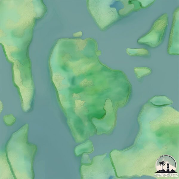
Welcome to Ko Hang, a Tropical island in the Malacca Strait, part of the majestic Pacific Ocean. This guide offers a comprehensive overview of what makes Ko Hang unique – from its geography and climate to its population, infrastructure, and beyond. Dive into the details:
Geography and size of Ko Hang
Size: 14.2 km²
Coastline: 20.8 km
Ocean: Pacific Ocean
Sea: Malacca Strait
Continent: Asia
Ko Hang is a Medium Island spanning 14 km² with a coastline of 21 km.
Archipel: –
Tectonic Plate: Philippine Sea – An oceanic tectonic plate beneath the Philippine Sea, east of the Philippines. It’s involved in complex interactions with the surrounding Eurasian, Pacific, and Indo-Australian plates, leading to significant volcanic and seismic activity in the region.
The geographic heart of the island is pinpointed at these coordinates:
Latitude: 7.86136148 / Longitude: 99.01969995
Climate and weather of Ko Hang
Climate Zone: Tropical
Climate Details: Tropical Monsoon Climate
Temperature: Hot
Climate Characteristics: Characterized by heavy rainfall, high humidity, and uniformly high temperatures, but with a distinct short dry season. It features a seasonal reversal of prevailing wind directions.
Topography and nature of Ko Hang
Timezone: UTC+07:00
Timezone places: Asia/Jakarta
Max. Elevation: 62 m
Mean Elevation: 25 m
Vegetation: Evergreen Broadleaf Forest
Tree Coverage: 71%
The mean elevation is 25 m. The highest elevation on the island reaches approximately 62 meters above sea level. The island is characterized by Plains: Flat, low-lying lands characterized by a maximum elevation of up to 200 meters. On islands, plains are typically coastal lowlands or central flat areas.
Dominating Vegetation: Evergreen Broadleaf Forest
Characterized by dense, lush canopies of broadleaf trees that retain their leaves year-round. These forests are typically found in tropical and subtropical regions and are known for their high biodiversity. Ko Hang has a tree cover of 71 %.
Vegetation: 5 vegetation zones – Highly Diverse Island
With five different vegetation zones, these islands offer a rich tapestry of ecosystems. The variety could include dense forests, open meadows, wetlands, coastal zones, and more. This level of diversity supports an intricate web of life, with each zone playing a vital role in the overall ecological health and balance of the island.
Infrastructure and Travelling to Ko Hang
Does the island have a public airport? no.
There is no public and scheduled airport on Ko Hang. The nearest airport is Krabi Airport, located 24 km away.
Does the island have a major port? no.
There are no major ports on Ko Hang. The closest major port is KRABI, approximately 23 km away.
The mean population of Ko Hang is 117 per km². Ko Hang is Moderately Inhabited. The island belongs to Thailand.
Continuing your journey, Ko Sriboya is the next notable island, situated merely km away.
Amazing Koh Hong, Island In Krabi shot by @angelosdanalis
Koh Hong, a stunning island located in Krabi, Thailand, is truly a natural wonder. With its crystal-clear waters, lush greenery, and ...Amazing Koh Hong, Island In Krabi shot by @angelosdanalis
Koh Hong, a stunning island located in Krabi, Thailand, is truly a ...
Koh Hong, a stunning island located in Krabi, Thailand, is truly a natural wonder. With its crystal-clear waters, lush greenery, and ...
BLOWN AWAY by KOH CHANG 🏝️ FULL TOUR of the ISLAND
Koh Chang, Kood & Mak - Thailand Travel Guide 4K - Best Things To Do & Places To Visit
Links to the resorts I mentioned (shortened links will redirect you to ...
I REGRET KOH CHANG 5 REASONS TO AVOID!!
In this video i tell you why i REGRET going Koh Chang i give you 5 ...
In this video i tell you why i REGRET going Koh Chang i give you 5 reasons to avoid visiting Koh Chang island, this place wasnt ...
KOH CHANG 🇹🇭 The Quiet Side of Thailand’s Paradise Island
Let's explore Koh Chang - Thailand Ekster's Christmas Sale is live ...
Let's explore Koh Chang - Thailand Ekster's Christmas Sale is live from Dec 8–28, 2025. Get up to 64% off when you use my ...
Koh Chang 2026: Thailand's BEST Island? ($30/Day Backpacker Guide)
Welcome to Koh Chang! Just five hours from Bangkok lies Thailand's ...
Welcome to Koh Chang! Just five hours from Bangkok lies Thailand's hidden backpacker paradise—the authentic, raw, and ...
Top 10 Things To Do in Koh Chang
Looking for the best things to do in Koh Chang? Look no further! In ...
Looking for the best things to do in Koh Chang? Look no further! In this video, I've listed the top 10 places to visit in Koh Chang.
KOH CHANG 🇹🇭 Too Touristy — or Heaven in Thailand?
This week we explore more of Koh Chang - Thailand - Head to ...
Koh Chang Travel Guide 2026: Thailand’s Wild Island of Sea and Jungle
Koh Chang, known as the Elephant Island, lies close to Thailand's ...
Koh Chang, known as the Elephant Island, lies close to Thailand's eastern border with Cambodia, a place where mountains, ...
Thailand’s Most UNDERRATED Island 🇹🇭 (KOH CHANG)
Welcome to Koh Chang, one of Thailand's biggest islands, but not one ...
Welcome to Koh Chang, one of Thailand's biggest islands, but not one you hear about as often as the famous ones in the south.
Top things to do in Koh Chang, Thailand 🇹🇭
Where is the best place to stay in Koh Chang?
Work with me to plan an EPIC Thailand Adventure ...
IS KOH CHANG WORTH VISITING? 🇹🇭 | Thailand's Secret Island Paradise (2 Day Travel Vlog)
We're diving deep into Koh Chang, the legendary "Elephant Island" and ...
We're diving deep into Koh Chang, the legendary "Elephant Island" and Thailand's third largest island! Often completely ...
The most underrated island in Thailand | Koh Chang Island
Koh chang | The perfect Island of Thailand.
Hotels : Sylvan Hotel 5* Mam Kai Bae 3* (old but gold)
Hotels : Sylvan Hotel 5* Mam Kai Bae 3* (old but gold)
Is Koh Chang Thailand’s BEST Island? Top 20 Things to Do Before You Die!
Koh Chang, Thailand's second-largest island, is known for its lush ...
Koh Chang, Thailand's second-largest island, is known for its lush jungles, stunning beaches, and vibrant marine life. Here are the ...
MNIEJ ZNANA WYSPA W KRABI | KOH HONG
tajlandia #kohhong #krabi MNIEJ ZNANA WYSPA W KRABI | KOH HONG. ...
tajlandia #kohhong #krabi MNIEJ ZNANA WYSPA W KRABI | KOH HONG. Jednodniową wycieczkę na rajską wyspę z grupką ...
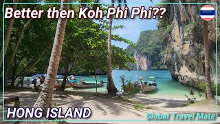
HONG ISLAND Krabi BEST 4 Island Tour 🇹🇭 Thailand
4 ISLAND Tour to HONG Island Krabi one of the best tours in Thailand. ...
4 ISLAND Tour to HONG Island Krabi one of the best tours in Thailand. We made a trip from Ao Nang Beach to Koh Hong, Koh ...
KOH CHANG - Is This Thailand’s Most Overlooked Island?
Ko Chang is a peaceful tropical island in Thailand, known for its lush ...
Ko Chang is a peaceful tropical island in Thailand, known for its lush jungles, quiet beaches, and relaxed atmosphere. Not too far ...
Thailand’s Best Kept Secret? Koh Chang Island
Koh Chang Island, Thailand, where the jungle meets the sea . Exploring ...
Koh Chang Island, Thailand, where the jungle meets the sea . Exploring Koh Chang Island, Thailand | Hidden Gem You ...
Elephant’s on Kai Bae Beach, Koh Chang. 🐘 #beach #thailand #kohchang #island #elephant #paradise
KOH KOOD is Thailand's BEST Paradise Island (MUST VISIT)
The Best Way to Koh Chang! 🚐✈️ Which one would you choose? #kohchang #thailand #travel
Klong Kloi Beach, Koh Chang 🏝️ #beach #kohchang #island #thailand #travel #paradise
Trauminsel Koh Chang Reisetipps | Was tun in Koh Chang?! | Thailand 2023
Koh Chang Reisetipps! Was tun in Koh Chang? Welche Koh Chang ...
Koh Chang Reisetipps! Was tun in Koh Chang? Welche Koh Chang Sehenswürdigkeiten gibt es? Ich zeige euch die ...
Thailand is classified as Emerging region: G20: Group of Twenty – Major economies comprising both developed and emerging countries, representing the world’s largest economies. The level of income is Upper middle income.
News – Latest Updates and Headlines from Ko Hang
Stay informed with the most recent news and important headlines from Ko Hang. Here’s a roundup of the latest developments.
Loading...
Please note: The data used here has been primarily extracted from satellite readings. Deviations from exact values may occur, particularly regarding the height of elevations and population density. Land area and coastline measurements refer to average values at mean high tide.