Welcome to Ko Kradat, a Tropical island in the Gulf of Thailand, part of the majestic Pacific Ocean. This guide offers a comprehensive overview of what makes Ko Kradat unique – from its geography and climate to its population, infrastructure, and beyond. Dive into the details:
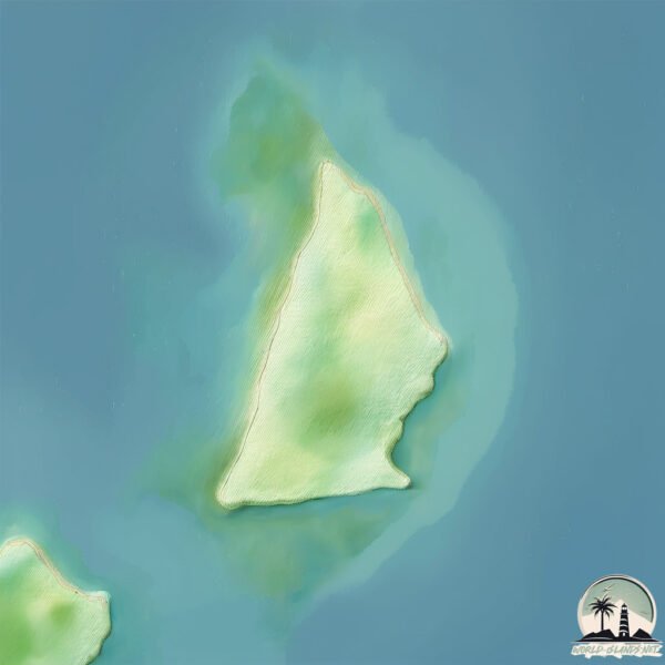
Geography and size of Ko Kradat
Size: 2.041 km²
Coastline: 6.9 km
Ocean: Pacific Ocean
Sea: Gulf of Thailand
Continent: Asia
Ko Kradat is a Small Island spanning 2 km² with a coastline of 6.9 km.
Archipel: –
Tectonic Plate: Sunda – Extends across Southeast Asia, encompassing parts of the Sunda Shelf, known for its interaction with the Australian Plate, contributing to volcanic activity in Indonesia.
The geographic heart of the island is pinpointed at these coordinates:
Latitude: 11.84172149 / Longitude: 102.52636805
Climate and weather of Ko Kradat
Climate Zone: Tropical
Climate Details: Tropical Monsoon Climate
Temperature: Hot
Climate Characteristics: Characterized by heavy rainfall, high humidity, and uniformly high temperatures, but with a distinct short dry season. It features a seasonal reversal of prevailing wind directions.
Topography and nature of Ko Kradat
Timezone: UTC+07:00
Timezone places: Asia/Jakarta
Max. Elevation: -2 m
Mean Elevation: -3 m
Vegetation: Open Woodland
Tree Coverage: 71%
The mean elevation is -3 m. Remarkably, this unique island barely emerges above the sea level, showcasing nature’s fascinating interplay with the ocean. The island is characterized by Plains: Flat, low-lying lands characterized by a maximum elevation of up to 200 meters. On islands, plains are typically coastal lowlands or central flat areas.
Dominating Vegetation: Open Woodland
Characterized by sparsely distributed trees with open canopy allowing sunlight to penetrate, supporting grasses and shrubs underneath. Often found in drier or transitional environments. Ko Kradat has a tree cover of 71 %.
Vegetation: 4 vegetation zones – Diverse Island
Four distinct vegetation zones mark these islands as ecologically diverse. They might feature varied landscapes such as forests, beaches, grasslands, and rocky areas. Such diversity reflects the island’s complex ecological interactions and varied habitats, which can support a rich array of wildlife and plant species.
Infrastructure and Travelling to Ko Kradat
Does the island have a public airport? no.
There is no public and scheduled airport on Ko Kradat. The nearest airport is Trat Airport, located 52 km away.
Does the island have a major port? no.
There are no major ports on Ko Kradat. The closest major port is RAYONG TPI TERMINAL, approximately 161 km away.
The mean population of Ko Kradat is 19 per km². Ko Kradat is Gently Populated. The island belongs to Thailand.
Continuing your journey, Ko Mak is the next notable island, situated merely km away.
Welcome to Koh Kradan, Thailand. A scenic island in paradise ❤️ #kohradan #thailand #paradise
Koh Kradan, Southern Thailand Short clip of this amazing island and beach tucked away in the south of Thailand - reachable ...Welcome to Koh Kradan, Thailand. A scenic island in paradise ❤️ #kohradan #thailand #paradise
Koh Kradan, Southern Thailand Short clip of this amazing island and ...
Koh Kradan, Southern Thailand Short clip of this amazing island and beach tucked away in the south of Thailand - reachable ...
Koh Kradat Private Island Tour (Deer Island) Koh Mak 🇹🇭 Thailand
Amazing Safari on Koh Kradat Island in Thailand, discover the 400 Deer ...
Amazing Safari on Koh Kradat Island in Thailand, discover the 400 Deer that live there. This Island also has some of the best ...
Flat Island (Koh Kradad), beyond my expectation, เกาะกระดาด
This 178 hectares trapezoid shaped island is located in Golf of ...
This 178 hectares trapezoid shaped island is located in Golf of Thailand, Trat province. In the middle of 3 famous islands, Koh ...
Koh Kradat Deer Island
Koh Kradat, deer island of Thailand. Music providet by youtube editor: ...
Koh Kradat, deer island of Thailand. Music providet by youtube editor: Huma-Huma - First Day Bird Creek - Aurora Borealis.
Koh Mak Detailed Travel Guide (Beaches, Activities & Accommodation) 🌊🌴😊
Discover Koh Mak, one of Thailand's unspoiled islands, with this ...
Discover Koh Mak, one of Thailand's unspoiled islands, with this detailed travel guide and aerial tour. Located in the Gulf of ...
Beautiful island Koh Kradad (Paper Island) near Koh Mak in Thailand
We just spent the weekend in Koh Mak, Trat Province and visited this ...
We just spent the weekend in Koh Mak, Trat Province and visited this interesting island called Koh Kradad (เกาะกระดาด) - Paper ...
Koh Kradat - Day Trip From Koh Mak To See The Deer & 1 Tree Island - Thailand 2024
Off the north east tip of Koh Mak is the small island of Koh Kradat. ...
Off the north east tip of Koh Mak is the small island of Koh Kradat. It is a very flat low lying island, thought to resemble a sheet of ...
Why This Tiny Thai Island Was Voted the World’s Most Beautiful Beach
Koh Kradan was voted the world's most beautiful beach, but does it ...
Koh Kradan was voted the world's most beautiful beach, but does it live up to the hype? In this video, I take you to Koh Kradan, ...
Swimming From Ko Mak to Ko Kradat in Thailand
I'm the redhead with the goggles. I met this Austrian man named Thomas ...
I'm the redhead with the goggles. I met this Austrian man named Thomas on a beach on the island of Ko Mak, THailand.
Koh Kradat island
via YouTube Capture.
via YouTube Capture.
KOH MAK 🇹🇭 Thailand's Quiet Paradise (Comparing Two Budgets)
This week let's explore KOH MAK - Thailand's quiet paradise Island - ...
This week let's explore KOH MAK - Thailand's quiet paradise Island - Download the Klook app or visit
http://www.klook.com and ...
This is Koh Kradad, my favorite mini island. Have you been there? Add this to your bucket list 🌏✏️
Welcome to Koh Kradad, Thailand's hidden gem! This breathtaking mini ...
Welcome to Koh Kradad, Thailand's hidden gem! This breathtaking mini island is a paradise like no other, with pristine beaches, ...
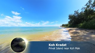
Koh Kradat
Peacefull privat Island north of Koh Mak - Insta360 One RS 1 Inch 360.
Peacefull privat Island north of Koh Mak - Insta360 One RS 1 Inch 360.
The Secret of Ko Mak: Experiencing Thailand's Timeless, Low-Carbon Beauty 🚲🥥 #IslandLife
Welcome to Ko Mak (also spelled Koh Maak or เกาะหมาก), a truly special ...
Welcome to Ko Mak (also spelled Koh Maak or เกาะหมาก), a truly special island in the Gulf of Thailand that embodies a timeless, ...
4K | KOH MAK & Koh Kham | Thailand's best kept secret | Travel Guide | 2024
Welcome to Koh Mak, Koh Kham and A&A Travelling. Koh Mak is part of ...
Welcome to Koh Mak, Koh Kham and A&A Travelling. Koh Mak is part of the Mu Koh Chang Marine National Park in eastern ...
Koh Kradad island
Koh kradad island #travel #thailand #Trat city.
Koh kradad island #travel #thailand #Trat city.
Koh Kradat
เกาะกระดาษ เกาะเล็กๆ ที่สวยงามและเงียบสงบ ...
เกาะกระดาษ เกาะเล็กๆ ที่สวยงามและเงียบสงบ ทางด้านทิศตะวันออกของเกาะหมาก เดินทางง่ายๆ เพียงแค่มาที่แหลมสนเกาะหมาก ...
koh Kradad :Private UNSEEN (Island) in Thailand
Private Island Thailand name :Koh Kradad ( Paper Island) PRIVATE ...
Private Island Thailand name :Koh Kradad ( Paper Island) PRIVATE ISLAND: size 474 acres in Thailand. Price 300 m.
Koh Kradat Thailand
travel #kohchang #thailand2024 #dronevideo #kohkradat #insta360acepro.
travel #kohchang #thailand2024 #dronevideo #kohkradat #insta360acepro.
Boattrip from Koh Chang to Koh Kradat, Koh Mak
Koh Chang, Koh Kradat, Koh Mak. ➖➖➖➖➖➖➖➖➖➖➖➖➖➖➖➖➖➖ SOCIAL MEDIA Website ...
Koh Chang, Koh Kradat, Koh Mak. ➖➖➖➖➖➖➖➖➖➖➖➖➖➖➖➖➖➖ SOCIAL MEDIA Website ...
97 passengers rescued after Koh Kood ferry suffers hull breach near Kradat Island
97 passengers rescued after Koh Kood ferry suffers hull breach near ...
97 passengers rescued after Koh Kood ferry suffers hull breach near Kradat Island . At around 12.30pm on Thursday (November ...
Koh Maak view to Koh Kradat at The huge very Long Cinnamon Pier
Der riesige Cinnamon Pier auf Koh Maak mit Blick auf die Bucht und der ...
Der riesige Cinnamon Pier auf Koh Maak mit Blick auf die Bucht und der kleinen vorgelagerten Insel Koh Kradat.
Thailand is classified as Emerging region: G20: Group of Twenty – Major economies comprising both developed and emerging countries, representing the world’s largest economies. The level of income is Upper middle income.
News – Latest Updates and Headlines from Ko Kradat
Stay informed with the most recent news and important headlines from Ko Kradat. Here’s a roundup of the latest developments.
Loading...
Please note: The data used here has been primarily extracted from satellite readings. Deviations from exact values may occur, particularly regarding the height of elevations and population density. Land area and coastline measurements refer to average values at mean high tide.