Welcome to Ko Talabeng, a Tropical island in the Malacca Strait, part of the majestic Pacific Ocean. This guide offers a comprehensive overview of what makes Ko Talabeng unique – from its geography and climate to its population, infrastructure, and beyond. Dive into the details:
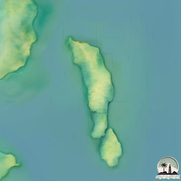
Geography and size of Ko Talabeng
Size: 1.492 km²
Coastline: 7.6 km
Ocean: Pacific Ocean
Sea: Malacca Strait
Continent: Asia
Ko Talabeng is a Small Island spanning 1.5 km² with a coastline of 7.6 km.
Archipel: –
Tectonic Plate: Sunda – Extends across Southeast Asia, encompassing parts of the Sunda Shelf, known for its interaction with the Australian Plate, contributing to volcanic activity in Indonesia.
The geographic heart of the island is pinpointed at these coordinates:
Latitude: 7.62979433 / Longitude: 99.14533965
Climate and weather of Ko Talabeng
Climate Zone: Tropical
Climate Details: Tropical Monsoon Climate
Temperature: Hot
Climate Characteristics: Characterized by heavy rainfall, high humidity, and uniformly high temperatures, but with a distinct short dry season. It features a seasonal reversal of prevailing wind directions.
Topography and nature of Ko Talabeng
Timezone: UTC+07:00
Timezone places: Asia/Jakarta
Max. Elevation: 74 m
Mean Elevation: 48 m
Vegetation: Evergreen Broadleaf Forest
Tree Coverage: 57%
The mean elevation is 48 m. The highest elevation on the island reaches approximately 74 meters above sea level. The island is characterized by Plains: Flat, low-lying lands characterized by a maximum elevation of up to 200 meters. On islands, plains are typically coastal lowlands or central flat areas.
Dominating Vegetation: Evergreen Broadleaf Forest
Characterized by dense, lush canopies of broadleaf trees that retain their leaves year-round. These forests are typically found in tropical and subtropical regions and are known for their high biodiversity. Ko Talabeng has a tree cover of 57 %.
Vegetation: 4 vegetation zones – Diverse Island
Four distinct vegetation zones mark these islands as ecologically diverse. They might feature varied landscapes such as forests, beaches, grasslands, and rocky areas. Such diversity reflects the island’s complex ecological interactions and varied habitats, which can support a rich array of wildlife and plant species.
Infrastructure and Travelling to Ko Talabeng
Does the island have a public airport? no.
There is no public and scheduled airport on Ko Talabeng. The nearest airport is Trang Airport, located 53 km away.
Does the island have a major port? no.
There are no major ports on Ko Talabeng. The closest major port is KANTANG HARBOR, approximately 48 km away.
The mean population of Ko Talabeng is 85 per km². Ko Talabeng is Gently Populated. The island belongs to Thailand.
Continuing your journey, Ko Lanta is the next notable island, situated merely km away.
#Livingonvacay Kayaking, Talabeng Island, Krabi, Thailand
Are you up for an adventure? This video takes you through an AMAZING kayaking experience into the heart of the Andaman Sea ...#Livingonvacay Kayaking, Talabeng Island, Krabi, Thailand
Are you up for an adventure? This video takes you through an AMAZING ...
Are you up for an adventure? This video takes you through an AMAZING kayaking experience into the heart of the Andaman Sea ...
welcome to Koh Lanta, Talabeng, Thailand!
Talabeng is located on the east side of Koh Lanta Noi, it has a ...
Talabeng is located on the east side of Koh Lanta Noi, it has a beautiful big cave, so don' t forget a flashlight and hiking shoes, ...
Koh Talabeng - Krabi, Thailand
Koh Talabeng - Krabi, Thailand For more details on Talabeng, have a ...
Koh Talabeng - Krabi, Thailand For more details on Talabeng, have a look on our travel blog. This is the link to the related blog ...
four Island tour, mangrove forest, Ko Talabeng, Ko ?, Ko Bubu! Thailand!
A fun ride withe the Bunch! Ko Talabeng and around the Islands!
A fun ride withe the Bunch! Ko Talabeng and around the Islands!
Koh Lanta’s Hidden Havens: Exclusive Speed Boat Tour | Koh Talabeng, Koh Bubu, & Lanta Old Town
Experience the exhilaration of island-hopping at its finest with ...
Experience the exhilaration of island-hopping at its finest with high-speed boat tours from Koh Jum Beach Villas. Set off from the ...
Mangrove Monkeys Koh Lanta, Thailand Koh Talabeng Tour
These monkeys live in the Mangrove Forrest at Koh Lanta. The Koh ...
These monkeys live in the Mangrove Forrest at Koh Lanta. The Koh Talabeng Tour makes a stop at the Island to feed the monkeys ...
Koh Talabeng| Koh Lanta| Krabi| Thailand Ko
It was amazing trip with kayak to the Koh Talabeng island KOH LANTA 2018.
It was amazing trip with kayak to the Koh Talabeng island KOH LANTA 2018.
Longtail Boat To Talabeng Island
From one day trip kayaking.
From one day trip kayaking.
Thailand - Koh Phee, Skull Island & Talabeng Tour
Today we went kayaking to explore Koh Khee Island aka Skull Island. ...
Today we went kayaking to explore Koh Khee Island aka Skull Island. Kop Phee is located on the east south side of Koh Lanta ...
Talabeng Island #thailand #kohlanta
Ko Lanta Noi : Ride to Ko Talabeng
WorlDClarK Ko Lanta Noi and Ko Talabeng, two stunning islands located ...
WorlDClarK Ko Lanta Noi and Ko Talabeng, two stunning islands located in the Andaman Sea. The drone captures the natural ...
Kayaking Talabeng in Thailand 2019
Talabeng Sea Kayaking trip.
Talabeng Sea Kayaking trip.
Kajakpaddling runt Koh talabeng - Thailand
Gustaf och Carina & Anna och Stefan paddlar kajak runt Koh talabeng, ...
Gustaf och Carina & Anna och Stefan paddlar kajak runt Koh talabeng, Thailand - hösten 09.
Kayaking | Koh Talabeng, Thailand with kids! #familytravel #travel #thailand
Kayaking around Koh Talabeng, an uninhabited island next to Koh Lanta, ...
Kayaking around Koh Talabeng, an uninhabited island next to Koh Lanta, Thailand is an unforgettable experience for the whole ...
Talabeng Kayaking @koh Lanta
One day trip .. Talabeng kayaking @Koh Lanta thailand.
One day trip .. Talabeng kayaking @Koh Lanta thailand.
Kajak, Talabeng Island
Dagsutflykt med Longtail Boat, kajakpaddling, apor m.m. Talabeng ...
Dagsutflykt med Longtail Boat, kajakpaddling, apor m.m. Talabeng Island, Koh Lanta, Thailand.
Hành trình ra đảo Koh Talabeng - Điệp Sơn thủy đạo (Ver Thái Lan)
Hành trình ra đảo Koh Talabeng - Điệp Sơn thủy đạo (Ver Thái Lan)
Hành trình ra đảo Koh Talabeng - Điệp Sơn thủy đạo (Ver Thái Lan)
Kayak Talabeng and island hopping on a Long-tail boat
A small snippet of one of our holiday adventures with the family ...
A small snippet of one of our holiday adventures with the family December Holiday 2023 Koh Lanta.
Koh Aung Island near Koh Lanta, Thailand Daytrip
Koh Aung Island is part of the Koh Talabeng tour from Green Tours from ...
Koh Aung Island is part of the Koh Talabeng tour from Green Tours from Koh Lanta. Location ...
@Samuiislandexplorer Talabeng Kayaking Koh Lanta
An amazing kayaking experience around Talabeng island Koh Lanta.
An amazing kayaking experience around Talabeng island Koh Lanta.
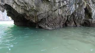
KO TALABENG CAVE S VÝKLADEM. Jak si SPRÁVNĚ vybrat výlet a potápění v THAJSKU s týmem NAUI.
KO TALABENG CAVE část výletu z východu ostrova Ko Lanta PS: pokud se ...
KO TALABENG CAVE část výletu z východu ostrova Ko Lanta PS: pokud se Vám moje video líbilo a těšíte se na NOVÉ ...
Thailand is classified as Emerging region: G20: Group of Twenty – Major economies comprising both developed and emerging countries, representing the world’s largest economies. The level of income is Upper middle income.
News – Latest Updates and Headlines from Ko Talabeng
Stay informed with the most recent news and important headlines from Ko Talabeng. Here’s a roundup of the latest developments.
Loading...
Please note: The data used here has been primarily extracted from satellite readings. Deviations from exact values may occur, particularly regarding the height of elevations and population density. Land area and coastline measurements refer to average values at mean high tide.