Welcome to Ko Thung Tu, a Tropical island in the Andaman or Burma Sea, part of the majestic Indian Ocean. This guide offers a comprehensive overview of what makes Ko Thung Tu unique – from its geography and climate to its population, infrastructure, and beyond. Dive into the details:
Geography and size of Ko Thung Tu
Size: 8.676 km²
Coastline: 23.9 km
Ocean: Indian Ocean
Sea: Andaman or Burma Sea
Continent: Asia
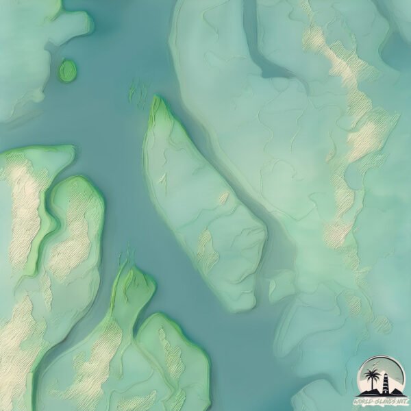
Ko Thung Tu is a Small Island spanning 8.7 km² with a coastline of 23.9 km.
Archipel: –
Tectonic Plate: Pacific – The world’s largest tectonic plate, covering much of the Pacific Ocean, known for the Pacific Ring of Fire with extensive seismic and volcanic activity.
The geographic heart of the island is pinpointed at these coordinates:
Latitude: 9.15115059 / Longitude: 98.32405494
Climate and weather of Ko Thung Tu
Climate Zone: Tropical
Climate Details: Tropical Monsoon Climate
Temperature: Hot
Climate Characteristics: Characterized by heavy rainfall, high humidity, and uniformly high temperatures, but with a distinct short dry season. It features a seasonal reversal of prevailing wind directions.
Topography and nature of Ko Thung Tu
Timezone: UTC+07:00
Timezone places: Asia/Jakarta
Max. Elevation: 1 m
Mean Elevation: -5 m
Vegetation: Mangrove Forest
Tree Coverage: 86%
The mean elevation is -5 m. The highest elevation on the island reaches approximately 1 meters above sea level. The island is characterized by Plains: Flat, low-lying lands characterized by a maximum elevation of up to 200 meters. On islands, plains are typically coastal lowlands or central flat areas.
Dominating Vegetation: Mangrove Forest
Found in coastal areas and river deltas, these unique wetland ecosystems are adapted to saline conditions and are crucial for coastal protection and biodiversity. Ko Thung Tu has a tree cover of 86 %.
Vegetation: 3 vegetation zones – Moderately Diverse Island
These islands start to show a broader range of ecological niches. With three vegetation zones, they may offer a mix of ecosystems like coastal areas, inland woods, and perhaps a distinct wetland or dry area. This diversity supports a wider range of flora and fauna, making these islands more ecologically complex than those with minimal diversity.
Infrastructure and Travelling to Ko Thung Tu
Does the island have a public airport? no.
There is no public and scheduled airport on Ko Thung Tu. The nearest airport is Ranong Airport, located 73 km away.
Does the island have a major port? no.
There are no major ports on Ko Thung Tu. The closest major port is KRABI, approximately 134 km away.
The mean population of Ko Thung Tu is 34 per km². Ko Thung Tu is Gently Populated. The island belongs to Thailand.
Continuing your journey, Ko Ra is the next notable island, situated merely km away.
Tung Tung Tung Sahur Arrested For Beating cappuccino Balerino #tungtungtungsahur
Tung Tung Tung Sahur Arrested For Beating cappuccino Balerino #tungtungtungsahur
Why Was Tung Tung Tung Sahur Removed?
shorts #robloxanimation #99nightsintheforest #99nightsintheforeststory ...
shorts #robloxanimation #99nightsintheforest #99nightsintheforeststory #99nightsintheforestanimation #stealabrainrot #sammy ...
All Blue của Sanji ở hồ tắm. #onepiece #shorts
Mong các bạn đăng ký giúp kênh ngày càng phát triển.!
Mong các bạn đăng ký giúp kênh ngày càng phát triển.!
The Unusual Taste of Tung Tung Tung Sahur #shorts #tungtungtungsahur
Godzilla has a long tongue #godzilla #kingkong #monster #godzillavskong #godzillamovie
Welcome to G&K, where we bring you exciting animated films for kids, ...
Welcome to G&K, where we bring you exciting animated films for kids, starring the legendary monsters Godzilla and King Kong in ...
gojo and geto years #duo ⚠️just friend
How Tung tung tung sahur would look in real life! #tungtungtungsahur #brainrot #horror
KRABI, THAILAND | 10 BEST Things To Do In Krabi (Ao Nang & Around)
Krabi is located on southern Thailand's west coast. Krabi is home to ...
Krabi is located on southern Thailand's west coast. Krabi is home to impressive limestone cliffs, dense mangrove forests, white ...
Places in Hong Kong That Don't Feel Real! 🇭🇰✨ #travel #nature #adventure #explorepage
Places in Hong Kong That Don't Feel Real! ✨ #travel #nature #adventure ...
Places in Hong Kong That Don't Feel Real! ✨ #travel #nature #adventure #explorepage Did you know Hong Kong mixes ...
REVIEW PHIM SINH TỒN TRÊN ĐẠI DƯƠNG || NOWHERE 2023 || SAKURA REVIEW
Chào mừng các bạn đến với kênh SAKURA REVIEW mình sẽ đăng video review ...
Chào mừng các bạn đến với kênh SAKURA REVIEW mình sẽ đăng video review phim hay mỗi ngày để các bạn xem nhé, nhớ ...
How to Spend 3 Days in KOH LANTA Thailand | The Perfect Travel Itinerary
Looking for a perfect 3 day travel itinerary to Koh Lanta? Look no ...
Looking for a perfect 3 day travel itinerary to Koh Lanta? Look no further! In this video, we'll show you how to spend your 3 days in ...
Yoga Pilates Reduce Belly Fat #workout #weightloss #losebellyfat
Yoga Pilates Reduce Belly Fat #workout #weightloss #losebellyfat.
Yoga Pilates Reduce Belly Fat #workout #weightloss #losebellyfat.
Sự Thật Kinh Hoàng Về Bộ Lạc Ăn Thịt Người Trên Đảo Bắc Sentinel! #shorts
Đảo Bắc Sentinel ở Ấn Độ – nơi không ai dám đặt chân tới! Được cho là ...
Đảo Bắc Sentinel ở Ấn Độ – nơi không ai dám đặt chân tới! Được cho là nơi sinh sống của bộ lạc nguyên thủy hung dữ, biệt lập ...
TUNG TUNG TUNG SAHUE TATATA SAHUR DINDINDINDINDUN MADINDINDUN LIRILI LARILA ORCALERO ORCALA BALERINA
Tung Tung Tung Sahur Vs Sooneeta 😂 #shorts
Tung Tung Tung Sahur Vs Sooneeta #shorts Discord: ...
ah len bình dương#slenderman#thiện
Larva Tuba - HAY ANH ĐÃ HẾT YÊU EM MẤT RỒI - ẤU TRÙNG TINH NGHỊCH - PHIM HOẠT HÌNH HAY NHẤT 2021
Larva Tuba - HAY ANH ĐÃ HẾT YÊU EM MẤT RỒI - ẤU TRÙNG TINH NGHỊCH - ...
Larva Tuba - HAY ANH ĐÃ HẾT YÊU EM MẤT RỒI - ẤU TRÙNG TINH NGHỊCH - PHIM HOẠT HÌNH HAY NHẤT 2021 ...
Jandel DESTROYED Grow a Garden.. 😱 #roblox #growagarden #jandel #update #new
Tung Tung Sahur Is BACK + Admin Abuse
Go follow my ROBLOX GROUP: ...
Google Earth Tìm Thấy Lá Cờ Việt Nam Tại Đảo Trường Sa và Dòng chữ L Yêu A | Khaikhampha #shorts
Cùng mình khám phá những điều bí ẩn Tiktok: Trịnh Quang Khải ...
Cùng mình khám phá những điều bí ẩn Tiktok: Trịnh Quang Khải #khaikhampha #trinhquangkhai #googleearth.
Hòn đảo nguy hiểm nhất thế giới? #shorts
Đây là hòn đảo nguy hiểm nhất thế giới, ngay cả quân đội cũng không ...
Đây là hòn đảo nguy hiểm nhất thế giới, ngay cả quân đội cũng không dám đến gần. Mối nguy hiểm không phải từ động vật ...
Indian Ocean Tsunami: The Last Minute [Part 1]
Tsunami: Inside the Disaster – A First-Person Cinematic Experience ...
Tsunami: Inside the Disaster – A First-Person Cinematic Experience This is not just a simulation—it's a complete immersion into ...
Peppa Jumps in a Muddy Puddle #shorts
Tung Tung Tung Sahur Bundle Review 🤣 Free Fire MAX #freefire #tungtungtungsahur
tungtungtungsahur #tungtungsahur #tungtungtung.
tungtungtungsahur #tungtungsahur #tungtungtung.
百歲老太竟是武林至尊!屠龍刀完全不是她的對手,輕鬆反擊! #kongfu #movie #chinesedrama #武侠片
歡迎來到【流浪剑客】|Welcome to Wandering Swordsman. 更多精彩內容丨More exciting ...
歡迎來到【流浪剑客】|Welcome to Wandering Swordsman. 更多精彩內容丨More exciting content : 本影片為頻道獨家原創的 ...
Thailand is classified as Emerging region: G20: Group of Twenty – Major economies comprising both developed and emerging countries, representing the world’s largest economies. The level of income is Upper middle income.
News – Latest Updates and Headlines from Ko Thung Tu
Stay informed with the most recent news and important headlines from Ko Thung Tu. Here’s a roundup of the latest developments.
Loading...
Please note: The data used here has been primarily extracted from satellite readings. Deviations from exact values may occur, particularly regarding the height of elevations and population density. Land area and coastline measurements refer to average values at mean high tide.


![Indian Ocean Tsunami: The Last Minute [Part 1]](https://i.ytimg.com/vi/7jscgHVwT2U/mqdefault.jpg)


