Ko Yo
Welcome to Ko Yo, a Tropical island in the Gulf of Thailand, part of the majestic Pacific Ocean. This guide offers a comprehensive overview of what makes Ko Yo unique – from its geography and climate to its population, infrastructure, and beyond. Dive into the details:
- Geography and Size: Explore the island’s size and location.
- Climate and Weather: Weather patterns and temperature.
- Topography and Nature: Uncover the natural wonders of the island.
- Infrastructure and Travelling: Insights on reaching, staying, and making the most of your visit.
- News and Headlines: Latest News.
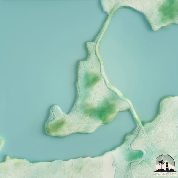
Geography and size of Ko Yo
Size: 5.916 km²
Coastline: 13.9 km
Ocean: Pacific Ocean
Sea: Gulf of Thailand
Continent: Asia
Ko Yo is a Small Island spanning 5.9 km² with a coastline of 13.9 km.
Archipel: –
Tectonic Plate: Pacific – The world’s largest tectonic plate, covering much of the Pacific Ocean, known for the Pacific Ring of Fire with extensive seismic and volcanic activity.
The geographic heart of the island is pinpointed at these coordinates:
Latitude: 7.16084538 / Longitude: 100.54158667
Climate and weather of Ko Yo
Climate Zone: Tropical
Climate Details: Tropical Monsoon Climate
Temperature: Hot
Climate Characteristics: Characterized by heavy rainfall, high humidity, and uniformly high temperatures, but with a distinct short dry season. It features a seasonal reversal of prevailing wind directions.
Topography and nature of Ko Yo
Timezone: UTC+07:00
Timezone places: Asia/Jakarta
Max. Elevation: 38 m
Mean Elevation: 25 m
Vegetation: Open Woodland
Tree Coverage: 49%
The mean elevation is 25 m. The highest elevation on the island reaches approximately 38 meters above sea level. The island is characterized by Plains: Flat, low-lying lands characterized by a maximum elevation of up to 200 meters. On islands, plains are typically coastal lowlands or central flat areas.
Dominating Vegetation: Open Woodland
Characterized by sparsely distributed trees with open canopy allowing sunlight to penetrate, supporting grasses and shrubs underneath. Often found in drier or transitional environments. Ko Yo has a tree cover of 49 %.
Vegetation: 5 vegetation zones – Highly Diverse Island
With five different vegetation zones, these islands offer a rich tapestry of ecosystems. The variety could include dense forests, open meadows, wetlands, coastal zones, and more. This level of diversity supports an intricate web of life, with each zone playing a vital role in the overall ecological health and balance of the island.
Infrastructure and Travelling to Ko Yo
Does the island have a public airport? no.
There is no public and scheduled airport on Ko Yo. The nearest airport is Hat Yai International Airport, located 28 km away.
Does the island have a major port? no.
There are no major ports on Ko Yo. The closest major port is SONGKHLA HARBOR, approximately 6 km away.
The mean population of Ko Yo is 1326 per km². Ko Yo is Densely Populated. The island belongs to Thailand.
Continuing your journey, Ko Nang Kham is the next notable island, situated merely km away.
Unforgettable day in Ko Yo Island | Paradise of Songkhla Thailand


Thailand is classified as Emerging region: G20: Group of Twenty – Major economies comprising both developed and emerging countries, representing the world’s largest economies. The level of income is Upper middle income.
News – Latest Updates and Headlines from Ko Yo
Stay informed with the most recent news and important headlines from Ko Yo. Here’s a roundup of the latest developments.
Please note: The data used here has been primarily extracted from satellite readings. Deviations from exact values may occur, particularly regarding the height of elevations and population density. Land area and coastline measurements refer to average values at mean high tide.