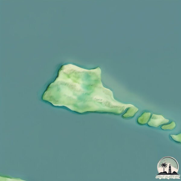
Welcome to Kõinastu Laid, a Continental island in the Gulf of Riga, part of the majestic Atlantic Ocean. This guide offers a comprehensive overview of what makes Kõinastu Laid unique – from its geography and climate to its population, infrastructure, and beyond. Dive into the details:
Geography and size of Kõinastu Laid
Size: 2.995 km²
Coastline: 8.8 km
Ocean: Atlantic Ocean
Sea: Gulf of Riga
Continent: Europe
Kõinastu Laid is a Small Island spanning 3 km² with a coastline of 8.8 km.
Archipel: –
Tectonic Plate: Eurasia – One of the world’s largest tectonic plates, the Eurasian Plate covers a significant portion of Europe and Asia. It’s characterized by diverse geological features, including the Ural Mountains, the European Plain, and the Himalayas formed from its collision with the Indian Plate.
The geographic heart of the island is pinpointed at these coordinates:
Latitude: 58.63432622 / Longitude: 23.02525466
Climate and weather of Kõinastu Laid
Climate Zone: Continental
Climate Details: Warm-Summer Humid Continental Climate
Temperature: Warm Summer
Climate Characteristics: Features warm summers and cold winters with consistent precipitation, common in higher latitudes.
Topography and nature of Kõinastu Laid
Timezone: UTC+02:00
Timezone places: Europe/Helsinki
Max. Elevation: 7 m
Mean Elevation: 4 m
Vegetation: Evergreen Needleleaf Forest
Tree Coverage: 92%
The mean elevation is 4 m. The highest elevation on the island reaches approximately 7 meters above sea level. The island is characterized by Plains: Flat, low-lying lands characterized by a maximum elevation of up to 200 meters. On islands, plains are typically coastal lowlands or central flat areas.
Dominating Vegetation: Evergreen Needleleaf Forest
Dominated by evergreen coniferous trees such as pines and firs, which retain their needle-like leaves throughout the year. These forests are often found in cooler climates. Kõinastu Laid has a tree cover of 92 %.
Vegetation: 6 vegetation zones – Very Highly Diverse Island
Islands in this range are ecological powerhouses, showcasing a wide array of vegetation zones. Each zone, from lush rainforests to arid scrublands, coastal mangroves to mountainous regions, contributes to a complex and interdependent ecosystem. These islands are often hotspots of biodiversity, supporting numerous species and intricate ecological processes.
Infrastructure and Travelling to Kõinastu Laid
Does the island have a public airport? no.
There is no public and scheduled airport on Kõinastu Laid. The nearest airport is Kärdla Airport, located 44 km away.
Does the island have a major port? no.
There are no major ports on Kõinastu Laid. The closest major port is OSMUSSAAR, approximately 82 km away.
The mean population of Kõinastu Laid is 1 per km². Kõinastu Laid is Gently Populated. The island belongs to Estonia.
Continuing your journey, Muhu is the next notable island, situated merely km away.
Road to Kõinastu island .Estonia
Road to Kõinastu island .Estonia
Kõinastu laid & Muhu Tõnise Talu (Saaremaa)
Reisiideid meie enda kaunis Eestis ...
Kõinastu hümn
Viisil “See on väike Muhu”, viisi autor Andres Klaas Sõnad Herbert Võrklaev.
Viisil “See on väike Muhu”, viisi autor Andres Klaas Sõnad Herbert Võrklaev.
TET. ESTONIA ISLANDS. MUHU & SAAREMAA. 2022. Trans Euro Trail
810 km along the Estonian islands by motorcycle. Part of the route on ...
810 km along the Estonian islands by motorcycle. Part of the route on Wikiloc: ...
Kõinastu laiu teekond rattaga
2019 a rattaretke "Kuidas elad, Muhumaa?" raames sai üritatud sõita ...
2019 a rattaretke "Kuidas elad, Muhumaa?" raames sai üritatud sõita rattaga Kõinasti laiule, peale 1,5km läbimist sai tagasi ...
Sliding in Kõinastu, august 2012
I had a little holiday in Saaremaa, and decided to try out Kõinastu ...
I had a little holiday in Saaremaa, and decided to try out Kõinastu with 16 knots blowing from NE. As the waterlevel near the ...
muhu saaremaa best of estonian islands
Saaremaa (Œsel en allemand) est la plus grande île de l'Estonie. ...
Saaremaa (Œsel en allemand) est la plus grande île de l'Estonie. Située dans la mer Baltique, au sud de l'île de Hiiumaa, elle ...
Saarelisuse uurimused: kogukondade igapäevaelust poliitikateni | Kogukondade uurimisrühma saade
Tartu Ülikooli ühiskonnateaduste instituudi kogukondade uurimisrühma ...
Tartu Ülikooli ühiskonnateaduste instituudi kogukondade uurimisrühma juht Dagmar Narusson vestles taskuhäälingu neljandas ...
Kicksleding trip to Hiiumaa islands
Taking off from Saarnaki island in Hiiumaa Estonia.
Taking off from Saarnaki island in Hiiumaa Estonia.
Rohuküla port
Rohuküla port and ferries Harilaid , St. Ola and Muhumaa.
Rohuküla port and ferries Harilaid , St. Ola and Muhumaa.
Hiiumaa saar
Hiiumaa saar ⛰ See saar on väike asustamata saar Läänemerel, mis ...
Hiiumaa saar ⛰ See saar on väike asustamata saar Läänemerel, mis kuulub Eesti riigile. Saar asub Hiiumaa põhjaranniku ...
Wild Nature in Hiiumaa Island, Estonia - Dagen Haus Guesthouse 2018
Hiiumaa island as the most forested region of Estonia is one of the ...
Hiiumaa island as the most forested region of Estonia is one of the best places to travel. Go biking and cycling; hit the untouched ...
Muhu ja Saaremaa reis ( dji phantom 4pro+ )
Hiiumaa circumnavigation 2014
Johan Wagner and Heleri Uus paddling around the estonian island of ...
Johan Wagner and Heleri Uus paddling around the estonian island of Hiiumaa during a week the summer of 2014.
Wonders of Estonia | The Most Amazing Places in Estonia | Travel Video 4K
Wonders of Estonia | The Most Amazing Places in Estonia | Travel Video ...
Wonders of Estonia | The Most Amazing Places in Estonia | Travel Video 4K Subscribe to the channel here, it's free but means a ...
Hiiumaa Island 2016
We gathered 6 families of friends, rented a beautiful house on remote ...
We gathered 6 families of friends, rented a beautiful house on remote Estonian Island and went for an unforgettable Midsummer ...
muhu koffee party kohvikutepäev 2021
Muhu, aussi appelée Muhumaa, est une île estonienne de l'archipel de ...
Muhu, aussi appelée Muhumaa, est une île estonienne de l'archipel de Moonsund dans la mer Baltique. Avec une superficie de ...
ESTONIA - Sea Kayak Circumnavigation of Hiiumaa in the Baltic Sea!
Last Summer I was kayaking in Estonia... One week and roughly 120km ...
Last Summer I was kayaking in Estonia... One week and roughly 120km around the Island Hiiumaa in the baltic sea.
Two days in Hiiumaa, Estonia
My group trip to Hiiumaa, the island of Estonia, May 4-5, 2019. Follow ...
Hiiumaa matk 27-28 dets 2016 42km
Taustaks mängib Vennaskond Revala Hümn.
Taustaks mängib Vennaskond Revala Hümn.
Roadtrip 2018 Trailer
In Estland bereisen wir die Inseln Hiiumaa und Kihnu Reisegeschichten ...
In Estland bereisen wir die Inseln Hiiumaa und Kihnu Reisegeschichten aus dem Baltikum gibt es in unserem Blog: ...
Suuskadega Hiiumaalt Muhumaale
Suusaretk üle külmunud Väinamere Hiiumaalt Muhumaale koos ...
Suusaretk üle külmunud Väinamere Hiiumaalt Muhumaale koos vahepeatustega Heinlaiul, Langekarel, Kõverlaiul. Retke pikkus ...
Paar katset Hiiumaal
Käepäraste vahenditega, õllekõrvale. Hiiumaa on ilus koht ja ...
Käepäraste vahenditega, õllekõrvale. Hiiumaa on ilus koht ja praamisõit on maarotile mõnus eksootika.
Hiiumaa surf
Your shorts-wearing narrator, Nico, describes the mighty whitecaps ...
Your shorts-wearing narrator, Nico, describes the mighty whitecaps near Kärdla, Hiiumaa, Estonia.
Estonia is classified as Developed region: nonG7: Developed economies outside of the Group of Seven, characterized by high income and advanced economic structures. The level of income is High income: OECD.
News – Latest Updates and Headlines from Kõinastu Laid
Stay informed with the most recent news and important headlines from Kõinastu Laid. Here’s a roundup of the latest developments.
Loading...
Please note: The data used here has been primarily extracted from satellite readings. Deviations from exact values may occur, particularly regarding the height of elevations and population density. Land area and coastline measurements refer to average values at mean high tide.