Komsomolets
Welcome to Komsomolets, a Polar island in the Kara Sea, part of the majestic Arctic Ocean. This guide offers a comprehensive overview of what makes Komsomolets unique – from its geography and climate to its population, infrastructure, and beyond. Dive into the details:
- Geography and Size: Explore the island’s size and location.
- Climate and Weather: Weather patterns and temperature.
- Topography and Nature: Uncover the natural wonders of the island.
- Infrastructure and Travelling: Insights on reaching, staying, and making the most of your visit.
- News and Headlines: Latest News.
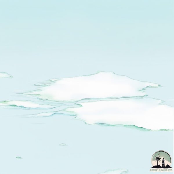
Geography and size of Komsomolets
Size: 8948 km²
Coastline: 1217 km
Ocean: Arctic Ocean
Sea: Kara Sea
Continent: Asia
Komsomolets is a Very Large Island spanning 8948 km² with a coastline of 1217 km.
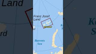
Archipel: Severnaya Zemlya – Located in the Russian high Arctic, these islands are known for their extreme northern latitude and harsh polar conditions.
Tectonic Plate: Eurasia – One of the world’s largest tectonic plates, the Eurasian Plate covers a significant portion of Europe and Asia. It’s characterized by diverse geological features, including the Ural Mountains, the European Plain, and the Himalayas formed from its collision with the Indian Plate.
The geographic heart of the island is pinpointed at these coordinates:
Latitude: 80.59185143 / Longitude: 94.98200349
Climate and weather of Komsomolets
Climate Zone: Polar
Climate Details: Ice Cap
Temperature: Cold
Climate Characteristics: The ice cap climate is the most extreme of the polar climates, characterized by a permanently frozen landscape. Temperatures rarely, if ever, rise above freezing, resulting in a barren, ice-covered environment with very little precipitation and no plant or animal life.
Topography and nature of Komsomolets
Timezone: UTC+08:00
Timezone places: Australia/Perth
Max. Elevation: 790 m
Mean Elevation: 259 m
Vegetation: Snow and Ice Covered
Tree Coverage: 5%
The mean elevation is 259 m. The highest elevation on the island reaches approximately 790 meters above sea level. The island is characterized by Plateau: Elevated flatlands rising sharply above the surrounding area, with a maximum elevation over 500 meters but a mean elevation less than 300 meters, forming unique highland areas on islands.
Dominating Vegetation: Snow and Ice Covered
These areas are permanently or seasonally covered in snow and ice, with little to no vegetation, such as polar regions and high mountains. Komsomolets has a tree cover of 5 %.
Vegetation: 4 vegetation zones – Diverse Island
Four distinct vegetation zones mark these islands as ecologically diverse. They might feature varied landscapes such as forests, beaches, grasslands, and rocky areas. Such diversity reflects the island’s complex ecological interactions and varied habitats, which can support a rich array of wildlife and plant species.
Infrastructure and Travelling to Komsomolets
Does the island have a public airport? no.
There is no public and scheduled airport on Komsomolets. The nearest airport is Khatanga Airport, located 1077 km away.
Does the island have a major port? no.
There are no major ports on Komsomolets. The closest major port is DUDINKA, approximately 1343 km away.
The mean population of Komsomolets is 0 per km². Komsomolets is Uninhabited. The island belongs to Russia.
The name of the island resonates across different cultures and languages. Here is how it is known around the world: Arabic: جزيرة كومسوموليتس; German: Komsomolez-Insel; Spanish: Isla Komsomolets; French: île Komsomolets; Portuguese: Ilha Komsomolets; Russian: Комсомолец; Chinese: 共青团员岛
Continuing your journey, Bol’shoy Izvestnikovyy is the next notable island, situated merely km away.
The Last Major Islands to be Discovered


Russia is classified as Emerging region: BRIC: Brazil, Russia, India, and China – Economies noted for their rapid growth and increasing influence on global affairs. The level of income is Upper middle income.
News – Latest Updates and Headlines from Komsomolets
Stay informed with the most recent news and important headlines from Komsomolets. Here’s a roundup of the latest developments.
- The threat of the ‘Komsomolets’: A Soviet nuclear submarine has been leaking radiation from the seabed for four decades - EL PAÍS Englishon 28 March 2026
The threat of the ‘Komsomolets’: A Soviet nuclear submarine has been leaking radiation from the seabed for four decades EL PAÍS English
- The Fate of a Soviet Nuclear Sub Decades After It Sank - Nautilus | Science Connectedon 25 March 2026
The Fate of a Soviet Nuclear Sub Decades After It Sank Nautilus | Science Connected
- Sunken nuclear submarine is leaking radioactive material intermittently - Physics Worldon 24 March 2026
Sunken nuclear submarine is leaking radioactive material intermittently Physics World
- Severnaya Zemlya May Be The Last Major Land Discovery On Planet Earth - IFLScienceon 7 February 2026
Severnaya Zemlya May Be The Last Major Land Discovery On Planet Earth IFLScience
- ‘Sir, We Lost a Nuclear Submarine’: Russia’s Titanium Sub Disaster (Lost Nukes) - The National Intereston 5 October 2024
‘Sir, We Lost a Nuclear Submarine’: Russia’s Titanium Sub Disaster (Lost Nukes) The National Interest
- Earth from space: Trio of ringed ice caps look otherworldly on Russian Arctic islands - Live Scienceon 17 June 2024
Earth from space: Trio of ringed ice caps look otherworldly on Russian Arctic islands Live Science
- Which microbes grow on Arctic islands? - Eidg. Forschungsanstalt WSLon 14 December 2023
Which microbes grow on Arctic islands? Eidg. Forschungsanstalt WSL
- The newest Arctic islands and straits: Origin and distribution, 1997–2021 - Wiley Online Libraryon 20 December 2022
The newest Arctic islands and straits: Origin and distribution, 1997–2021 Wiley Online Library
- Expedition underway to check leakages from reactor and two nukes on Arctic seabed - The Barents Observeron 21 May 2021
Expedition underway to check leakages from reactor and two nukes on Arctic seabed The Barents Observer
- A year long expedition spotlights night life in the Arctic winter - Science Newson 8 April 2020
A year long expedition spotlights night life in the Arctic winter Science News
Social Media Posts about Komsomolets
Please note: The data used here has been primarily extracted from satellite readings. Deviations from exact values may occur, particularly regarding the height of elevations and population density. Land area and coastline measurements refer to average values at mean high tide.