Koniuji
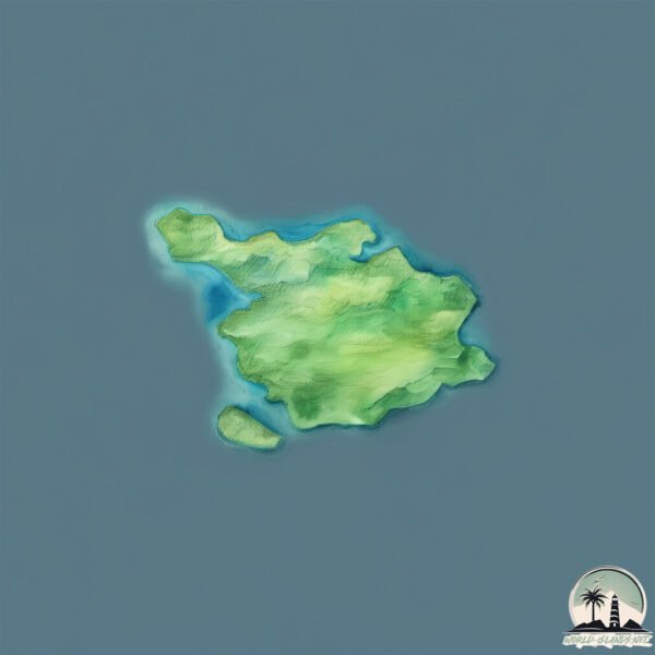
Welcome to Koniuji, a Polar island in the Bering Sea, part of the majestic Pacific Ocean. This guide offers a comprehensive overview of what makes Koniuji unique – from its geography and climate to its population, infrastructure, and beyond. Dive into the details:
- Geography and Size: Explore the island’s size and location.
- Climate and Weather: Weather patterns and temperature.
- Topography and Nature: Uncover the natural wonders of the island.
- Infrastructure and Travelling: Insights on reaching, staying, and making the most of your visit.
- News and Headlines: Latest News.
Geography and size of Koniuji
Size: 0.891 km²
Coastline: 8.1 km
Ocean: Pacific Ocean
Sea: Bering Sea
Continent: North America
Koniuji is a Tiny Island spanning 0.891 km² with a coastline of 8.1 km.
Archipel: Aleutian Islands – A chain of islands stretching from Alaska to Russia, known for their rugged beauty, abundant wildlife, and volcanic activity.
Tectonic Plate: North America – Covers North America and parts of the Atlantic and Arctic Oceans, characterized by diverse geological features and varying levels of seismic activity.
The geographic heart of the island is pinpointed at these coordinates:
Latitude: 52.22112863 / Longitude: -175.13179328
Climate and weather of Koniuji
Climate Zone: Polar
Climate Details: Tundra
Temperature: Cold
Climate Characteristics: The tundra climate features long, extremely cold winters and short, cool summers. Vegetation is limited to mosses, lichens, and small shrubs due to the low temperatures and short growing seasons. Biodiversity is low, but some specialized species thrive.
Topography and nature of Koniuji
Timezone: UTC-10:00
Timezone places: Pacific/Honolulu
Max. Elevation: 203 m
Mean Elevation: 182 m
Vegetation: Deciduous Needleleaf Forest
Tree Coverage: 87%
The mean elevation is 182 m. The highest elevation on the island reaches approximately 203 meters above sea level. The island is characterized by Hills: Gently sloping landforms with rounded tops, having a maximum elevation between 200 and 500 meters. Hills contribute to a varied landscape on islands.
Dominating Vegetation: Deciduous Needleleaf Forest
Consists of needleleaf trees that shed their needles annually. This type of forest is less common and can be found in certain cold, northern regions. Koniuji has a tree cover of 87 %.
Vegetation: 2 vegetation zones – Low Diversity Island
Islands with two distinct vegetation zones offer slightly more ecological variety. These zones could be due to differences in elevation, moisture, or other environmental factors. While still limited in biodiversity, these islands may offer a contrast between the two zones, such as a coastline with mangroves and an inland area with grassland.
Infrastructure and Travelling to Koniuji
Does the island have a public airport? no.
There is no public and scheduled airport on Koniuji. The nearest airport is Adak Airport, located 171 km away.
Does the island have a major port? no.
There are no major ports on Koniuji. The closest major port is PALISADES POINT, approximately 106 km away.
The mean population of Koniuji is 0 per km². Koniuji is Uninhabited. The island belongs to United States of America.
Continuing your journey, Tagalak is the next notable island, situated merely km away.
Koniuji Island Top # 6 Facts


United States of America is classified as Developed region: G7: Group of Seven – Major advanced economies, including Canada, France, Germany, Italy, Japan, the United Kingdom, and the United States. The level of income is High income: OECD.
News – Latest Updates and Headlines from Koniuji
Stay informed with the most recent news and important headlines from Koniuji. Here’s a roundup of the latest developments.
Please note: The data used here has been primarily extracted from satellite readings. Deviations from exact values may occur, particularly regarding the height of elevations and population density. Land area and coastline measurements refer to average values at mean high tide.