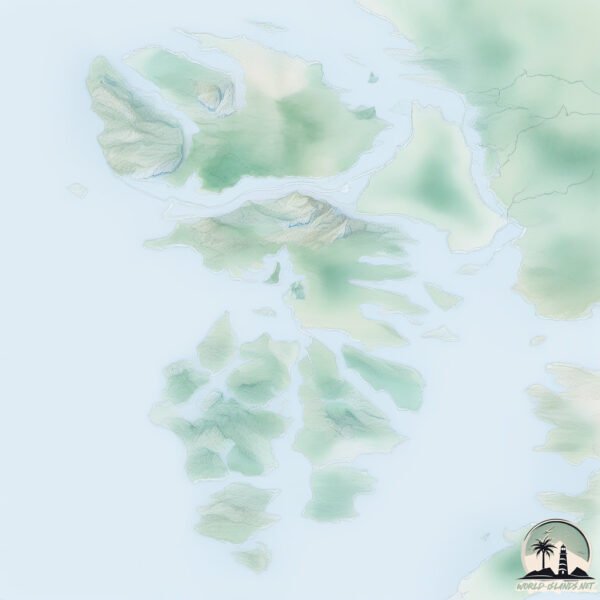
Welcome to Kuiu, a Temperate island in the The Coastal Waters of Southeast Alaska and British Columbia, part of the majestic Pacific Ocean. This guide offers a comprehensive overview of what makes Kuiu unique – from its geography and climate to its population, infrastructure, and beyond. Dive into the details:
Geography and size of Kuiu
Size: 1992 km²
Coastline: 1543 km
Ocean: Pacific Ocean
Sea: The Coastal Waters of Southeast Alaska and British Columbia
Continent: North America
Kuiu is a Very Large Island spanning 1992 km² with a coastline of 1543 km.
Archipel: Alexander Archipelago – A group of about 1,100 islands off the southeast coast of Alaska, USA, known for their temperate rainforests and indigenous Tlingit culture.
Tectonic Plate: North America – Covers North America and parts of the Atlantic and Arctic Oceans, characterized by diverse geological features and varying levels of seismic activity.
The geographic heart of the island is pinpointed at these coordinates:
Latitude: 56.54404535 / Longitude: -134.07476075
Climate and weather of Kuiu
Climate Zone: Temperate
Climate Details: Temperate Oceanic Climate
Temperature: Warm Summer
Climate Characteristics: Known for its moderate year-round temperatures with ample rainfall and no dry season. Warm summers are characteristic.
Topography and nature of Kuiu
Timezone: UTC-09:00
Timezone places: America/Anchorage
Max. Elevation: 927 m
Mean Elevation: 194 m
Vegetation: Evergreen Needleleaf Forest
Tree Coverage: 67%
The mean elevation is 194 m. The highest elevation on the island reaches approximately 927 meters above sea level. The island is characterized by Plateau: Elevated flatlands rising sharply above the surrounding area, with a maximum elevation over 500 meters but a mean elevation less than 300 meters, forming unique highland areas on islands.
Dominating Vegetation: Evergreen Needleleaf Forest
Dominated by evergreen coniferous trees such as pines and firs, which retain their needle-like leaves throughout the year. These forests are often found in cooler climates. Kuiu has a tree cover of 67 %.
Vegetation: 11 vegetation zones – Exceptionally Diverse Island
Islands with more than ten vegetation zones are among the most ecologically rich and varied in the world. These islands are akin to miniature continents, boasting an incredible array of ecosystems. The sheer range of habitats, from high peaks to deep valleys, rainforests to deserts, creates a mosaic of life that is unparalleled. They are crucial for conservation and ecological studies.
Infrastructure and Travelling to Kuiu
Does the island have a public airport? no.
There is no public and scheduled airport on Kuiu. The nearest airport is Port Protection Seaplane Base, located 25 km away.
Does the island have a major port? yes.
Kuiu is home to a major port. The following ports are situated on the island: WASHINGTON BAY, BAY OF PILLARS.
The mean population of Kuiu is 0 per km². Kuiu is Uninhabited. The island belongs to United States of America.
Continuing your journey, Coronation is the next notable island, situated merely km away.
"Turning the Tide" | Kuiu Island Bear Hunt | 4K Film 2024
Hunting Black Bears on Kuiu Island with Adam Millburn and Blaine Millburn Produced by Blaine Millburn May, 2024."Turning the Tide" | Kuiu Island Bear Hunt | 4K Film 2024
Hunting Black Bears on Kuiu Island with Adam Millburn and Blaine ...
Hunting Black Bears on Kuiu Island with Adam Millburn and Blaine Millburn Produced by Blaine Millburn May, 2024.
Kuiu Island Black Bear Hunt
During this camping/ hunting trip, we saw 3 wolfs, 3 black bears, a ...
During this camping/ hunting trip, we saw 3 wolfs, 3 black bears, a moose, and hundreds of sea otters. We attempted a stalk on a ...
Kuiu Island Archery Black Bear Hunt
A black bear I harvested several years ago while archery hunting.
A black bear I harvested several years ago while archery hunting.
Island-Hopping through the Tongass | Kuiu, Kupreanof & Prince of Wales - Ep. 34
In this episode, we continue our sailing journey through **Southeast ...
In this episode, we continue our sailing journey through **Southeast Alaska**, island-hopping deep into the **Tongass National ...
Back To The Rock - Kodiak Mountain Goat
Kodiak! No other place can match the legendary lore of this Island, ...
Kodiak! No other place can match the legendary lore of this Island, notoriously and fondly known as the Rock! Continuously ...
KUIU’s BEARS
Hunting Alaska Black Bears in the temperate old growth forest of ...
Hunting Alaska Black Bears in the temperate old growth forest of Southeast Alaska. Salmon, Birds and Bears join four friend on an ...
Kuiu Island ,Black Bear sow and cubs
Kuiu Island,Black Bear sow and cubs.
Kuiu Island,Black Bear sow and cubs.
Watch Our Alaska Moose Hunt On Kuiu!!!!
We officially won the Kuiu Film Festival. Thank you all for voting for ...
We officially won the Kuiu Film Festival. Thank you all for voting for us!!!!
Kuiu Island, Bay of Pillars
Visiting Bay of Pillars at the house of a friend, who lives OFF the ...
Visiting Bay of Pillars at the house of a friend, who lives OFF the grid in all respects, and he is the only person there!
Helping build a lodge on Kuiu Island // B-Roll
Great memories from 2016. Used a mix of cameras including my Samsun ...
Great memories from 2016. Used a mix of cameras including my Samsun Note (5 I believe). I think I borrowed my brother's GoPro ...
Hamilton Cove off Kuiu Island
Kuiu Island Spring Black Bear Hunt
Hunting Kuiu and Kupreanof Islands for spring black bears. We hunted ...
Hunting Kuiu and Kupreanof Islands for spring black bears. We hunted out of a boat, spot and stalked, and explored logging roads ...
Camping on Southeast Alaska’s Kuiu Island
Ken O Kuiu Black Bear, 2025.
Kuiu island black bear.
Kuiu island black bear.
Critters on Kuiu Island Intertidal Zone, Alaska
We head out to Kuiu Island to explore an intertidal zone by Saginaw ...
We head out to Kuiu Island to explore an intertidal zone by Saginaw Bay in the Tongass National Forest from our base the ...
Kuiu Island
Video Software we use:
https://amzn.to/2KpdCQF Ad-free videos. You can support us by purchasing something through our ...
What happened to Port Protection Gary Muehlberger Gary’s Dog Trapper? #lifebelowzeroportprotection
lifebelowzero #portprotection #garymuehlberger.
lifebelowzero #portprotection #garymuehlberger.
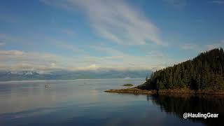
Frederick Sound View of Kuiu, Baranof and Admiralty Islands
Black Bear Flipping Rocks - Kuiu Island, southeast Alaska
A short video of a black bear turning rocks over looking for food at ...
A short video of a black bear turning rocks over looking for food at low tide, Kuiu Island in southeast Alaska.
Cape Decision, Kuiu Island
A quick look at one of the most beautiful places on Earth and a ...
A quick look at one of the most beautiful places on Earth and a challenge to help keep it that way. The Ikkatsu Project is organizing ...
Honeydew Cove - Kuiu Island, Alaska
July 30, 2023 - Very calm conditions and clear forecast, so we ...
July 30, 2023 - Very calm conditions and clear forecast, so we anchored in front of the arch in 80'. Good hold with a fantastic ...
Anchored at the edge of the Tongass National Forest 🌲 - Ep. 33
Thank you for watching! In this episode, we anchor in a quiet cove on ...
Thank you for watching! In this episode, we anchor in a quiet cove on Kuiu Island at the edge of the Tongass National Forest.
SAM CARLSON sighting! #portprotection #alaska
Sam just stopped by Terri's place so we bombarded him with the gifts ...
Sam just stopped by Terri's place so we bombarded him with the gifts that have been sent by the fans. When you get a Sam ...
Peak Salmon Survey Northern Kupreanof Island, Northern Kuiu, mainland Southheast Alaska
sped up X2.
sped up X2.
United States of America is classified as Developed region: G7: Group of Seven – Major advanced economies, including Canada, France, Germany, Italy, Japan, the United Kingdom, and the United States. The level of income is High income: OECD.
News – Latest Updates and Headlines from Kuiu
Stay informed with the most recent news and important headlines from Kuiu. Here’s a roundup of the latest developments.
Loading...
Social Media Posts about Kuiu
Loading...
Please note: The data used here has been primarily extracted from satellite readings. Deviations from exact values may occur, particularly regarding the height of elevations and population density. Land area and coastline measurements refer to average values at mean high tide.