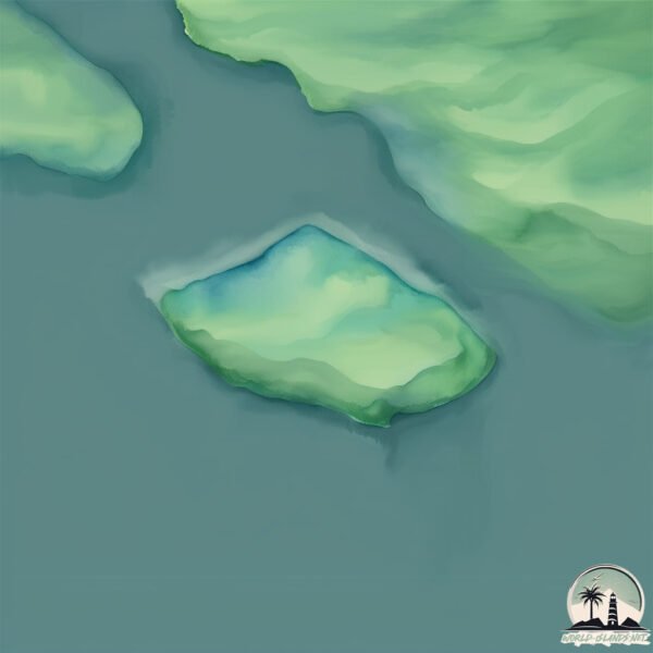
Welcome to Kumealon Island, a Temperate island in the The Coastal Waters of Southeast Alaska and British Columbia, part of the majestic Pacific Ocean. This guide offers a comprehensive overview of what makes Kumealon Island unique – from its geography and climate to its population, infrastructure, and beyond. Dive into the details:
Geography and size of Kumealon Island
Size: 0.189 km²
Coastline: 2 km
Ocean: Pacific Ocean
Sea: The Coastal Waters of Southeast Alaska and British Columbia
Continent: North America
Kumealon Island is a Tiny Island spanning 0.189 km² with a coastline of 2 km.
Archipel: –
Tectonic Plate: North America – Covers North America and parts of the Atlantic and Arctic Oceans, characterized by diverse geological features and varying levels of seismic activity.
The geographic heart of the island is pinpointed at these coordinates:
Latitude: 53.85631469 / Longitude: -130.02472998
Climate and weather of Kumealon Island
Climate Zone: Temperate
Climate Details: Temperate Oceanic Climate
Temperature: Warm Summer
Climate Characteristics: Known for its moderate year-round temperatures with ample rainfall and no dry season. Warm summers are characteristic.
Topography and nature of Kumealon Island
Timezone: UTC-08:00
Timezone places: America/Los_Angeles
Max. Elevation: 43 m
Mean Elevation: -2 m
Vegetation: Mixed Forest
Tree Coverage: 66%
The mean elevation is -2 m. The highest elevation on the island reaches approximately 43 meters above sea level. The island is characterized by Plains: Flat, low-lying lands characterized by a maximum elevation of up to 200 meters. On islands, plains are typically coastal lowlands or central flat areas.
Dominating Vegetation: Mixed Forest
A combination of both deciduous and evergreen trees, often found in transitional zones between forest types. These forests offer a diverse habitat for various wildlife species. Kumealon Island has a tree cover of 66 %.
Vegetation: 1 vegetation zones – Minimal Diversity Island
These islands exhibit the most basic level of ecological diversity, often characterized by a single dominant vegetation type. This could be due to extreme environmental conditions, limited land area, or significant human impact. They represent unique ecosystems where specific species have adapted to thrive in these singular environments.
Infrastructure and Travelling to Kumealon Island
Does the island have a public airport? no.
There is no public and scheduled airport on Kumealon Island. The nearest airport is Prince Rupert Airport, located 66 km away.
Does the island have a major port? no.
There are no major ports on Kumealon Island. The closest major port is PORPOISE HARBOR, approximately 49 km away.
The mean population of Kumealon Island is 0 per km². Kumealon Island is Uninhabited. The island belongs to Canada.
Continuing your journey, Kennedy is the next notable island, situated merely km away.
Kumealon Island Anchorage
Our trip from Hartley Bay to Kumealon Island. The visibility was low with mist and rain. Turning into Grenville Channel, the wind ...Kumealon Island Anchorage
Our trip from Hartley Bay to Kumealon Island. The visibility was low ...
Our trip from Hartley Bay to Kumealon Island. The visibility was low with mist and rain. Turning into Grenville Channel, the wind ...
Kumealon Cove British Columbia
Anchored in BC.
Anchored in BC.
Dinghy Ride! Kumealon Inlet BC Canada 6/29/22
Dad and I taking a little dinghy trip up the the falls. Unedited.
Dad and I taking a little dinghy trip up the the falls. Unedited.
Life is Like Sailing - Lewis Island
In this episode I leave Kumealon Inlet and anchor behind Lewis Island ...
In this episode I leave Kumealon Inlet and anchor behind Lewis Island then head back to Prince Rupert the day after that. PLUS I ...
Keswar Inlet Anchorage, British Columbia
Waiting to cross Hecate Strait to Haida Gwaii, we sit at a remote ...
Waiting to cross Hecate Strait to Haida Gwaii, we sit at a remote anchorage as gale force winds pummel Hecate Strait.
Life is Like Sailing - Kumealon Inlet - Part 2
In this episode I check out the narrows leading to Kumealon Lagoon. ...
In this episode I check out the narrows leading to Kumealon Lagoon. Don't forget to THUMBS UP, SHARE and SUBSCRIBE if you ...
TROUBLE SAILING around ATUONA, Secret Anchorages - Hiva Oa - Tahuata - Fatu Hiva - Hanemenu S2E12
Linus and Daly's sailing trip to and from Atuona, Hiva Oa was filled ...
Linus and Daly's sailing trip to and from Atuona, Hiva Oa was filled with mishaps and set backs, but they find awesome ...
He Is Building a DIY Electric Sailboat!! - Walde Sailing ep.46 (Vancouver Island)
We leave the beautiful Wallace Island and set off to visit our friend, ...
We leave the beautiful Wallace Island and set off to visit our friend, Simon, on Gabriola Island and help him out on his project of ...
Kitkatla BC first day of work at Lach Klan School
My walk to work by the ocean and some views from inside the school and ...
My walk to work by the ocean and some views from inside the school and band office.
Forgotten Village | Tahsis, British Columbia
Staccato AV made a visit to Tahsis BC at the end of August, 2020. Here ...
Staccato AV made a visit to Tahsis BC at the end of August, 2020. Here are some aerial scenes from that trip. Be sure to watch in ...
Blasting up Bute Inlet, BC
Wild Encounters In British Columbia - Ep. 130 RAN Sailing
Meet Bertil, our new crew member that joined us spontaneously in ...
Meet Bertil, our new crew member that joined us spontaneously in Kumealon Inlet 🙂 The sun is shining in "Rainy Rupert" and we ...
Butedale
Butedale, British Columbia. June, 2016.
Butedale, British Columbia. June, 2016.
Sailing down Princess Louisa Inlet
Kittywake Anchorage: Small Inlet, Quadra Island, British Columbia (July 11, 2021
Small Inlet is on the northwest side of Quadra Island and is accessed ...
Small Inlet is on the northwest side of Quadra Island and is accessed from Discovery Passage via Kanish Bay north of Seymour ...
Life is Like Sailing - Inside Passage - Ep 09
No Patreon, No Ads, Just content for you to enjoy. Music by: Las Lunas ...
No Patreon, No Ads, Just content for you to enjoy. Music by: Las Lunas - 'Know Me'
Ep. 45 Haida Gwaii, Rated as one of 10 by National Geographic.
Rec date 2017 09 16 Haida Gwaii consists of two main islands: Graham ...
Rec date 2017 09 16 Haida Gwaii consists of two main islands: Graham Island in the north and Moresby Island in the south.
Life is Like Sailing - Inside Passage - Ep 12
No Patreon, No Ads, Just content for you to enjoy.
No Patreon, No Ads, Just content for you to enjoy.
Sailing the Inside Passage - Spicer Anchorage and Grenville Channel
An unsuccessful attempt to cross Hecate Strait to Haida Gwaii ...
An unsuccessful attempt to cross Hecate Strait to Haida Gwaii (formerly the Queen Charlotte Islands) too late in the season in ...
Chapter 12 - Prince Rupert
We finally get through Grenville Channel, and into Prince Rupert, ...
We finally get through Grenville Channel, and into Prince Rupert, where we end up staying for quite awhile exploring the area and ...
72 hours in Kitkatla British Columbia Beltane May Day nature walk
My first 72 hours living in Kitkatla BC. Isolating 14 days before ...
My first 72 hours living in Kitkatla BC. Isolating 14 days before contact with community members. Lots of time to explore.
Lowe inlet British Columbia
Waterfall.
Waterfall.
Ep. 68 Alaska: Geographic Bay - Seward
Rec date 2018-08-18 Sailing in Alaska from Geographic Bay, to Seward ...
Rec date 2018-08-18 Sailing in Alaska from Geographic Bay, to Seward on Ammonite, a Nordhavn 78 Motor Yacht.
Canada is classified as Developed region: G7: Group of Seven – Major advanced economies, including Canada, France, Germany, Italy, Japan, the United Kingdom, and the United States. The level of income is High income: OECD.
News – Latest Updates and Headlines from Kumealon Island
Stay informed with the most recent news and important headlines from Kumealon Island. Here’s a roundup of the latest developments.
Loading...
Please note: The data used here has been primarily extracted from satellite readings. Deviations from exact values may occur, particularly regarding the height of elevations and population density. Land area and coastline measurements refer to average values at mean high tide.