La Palma
Welcome to La Palma, a Temperate island in the North Atlantic Ocean, part of the majestic Atlantic Ocean. This guide offers a comprehensive overview of what makes La Palma unique – from its geography and climate to its population, infrastructure, and beyond. Dive into the details:
- Geography and Size: Explore the island’s size and location.
- Climate and Weather: Weather patterns and temperature.
- Topography and Nature: Uncover the natural wonders of the island.
- Infrastructure and Travelling: Insights on reaching, staying, and making the most of your visit.
- News and Headlines: Latest News.
Geography and size of La Palma
Size: 707.8 km²
Coastline: 155.6 km
Ocean: Atlantic Ocean
Sea: North Atlantic Ocean
Continent: Africa
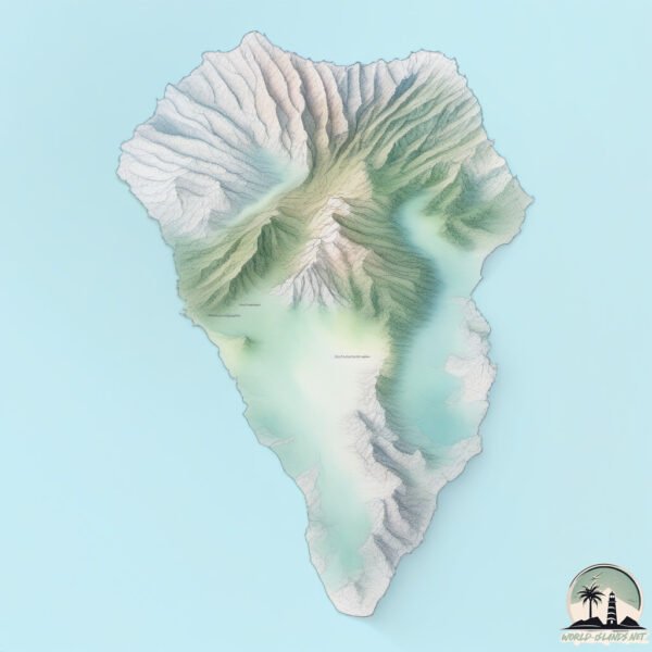
La Palma is a Large Island spanning 708 km² with a coastline of 156 km.
Archipel: Canary Islands – A Spanish archipelago off the coast of northwestern Africa, known for their volcanic landscapes, unique ecosystems, and vibrant cultures.
Tectonic Plate: Africa – One of the world’s largest tectonic plates, covering the African continent and parts of the surrounding oceans, known for its stability with some active rift zones.
The geographic heart of the island is pinpointed at these coordinates:
Latitude: 28.68962931 / Longitude: -17.85702395
Climate and weather of La Palma
Climate Zone: Temperate
Climate Details: Warm-Summer Mediterranean Climate
Temperature: Warm Summer
Climate Characteristics: Characterized by warm, dry summers and mild, wet winters, typical of coastal areas with abundant sunshine Rain is more common in the winter months, maintaining a moderate climate.
Topography and nature of La Palma
Timezone: UTC±00:00
Timezone places: Europe/Lisbon
Max. Elevation: 2423 m Roque de los Muchachos
Mean Elevation: 849 m
Vegetation: Evergreen Broadleaf Forest
Tree Coverage: 45%
The mean elevation is 849 m. Dominating the island’s landscape, the majestic “Roque de los Muchachos” rises as the highest peak, soaring to impressive heights. The island is characterized by Mountains: High, steeply elevated landforms. Characterized by both a high maximum elevation (over 500 meters) and a high mean elevation, creating rugged, mountainous terrains on islands.
Dominating Vegetation: Evergreen Broadleaf Forest
Characterized by dense, lush canopies of broadleaf trees that retain their leaves year-round. These forests are typically found in tropical and subtropical regions and are known for their high biodiversity. La Palma has a tree cover of 45 %.
Vegetation: 13 vegetation zones – Exceptionally Diverse Island
Islands with more than ten vegetation zones are among the most ecologically rich and varied in the world. These islands are akin to miniature continents, boasting an incredible array of ecosystems. The sheer range of habitats, from high peaks to deep valleys, rainforests to deserts, creates a mosaic of life that is unparalleled. They are crucial for conservation and ecological studies.
Infrastructure and Travelling to La Palma
Does the island have a public airport? yes.
La Palma has a public and scheduled airport. The following airports are located on this island: La Palma Airport.
Does the island have a major port? no.
There are no major ports on La Palma. The closest major port is SANTA CRUZ DE LA PALMA, approximately 1 km away.
The mean population of La Palma is 141 per km². La Palma is Moderately Inhabited. The island belongs to Spain.
The name of the island resonates across different cultures and languages. Here is how it is known around the world: Arabic: لا بالما; German: La Palma; Spanish: La Palma; French: La Palma; Portuguese: La Palma; Russian: Пальма; Chinese: 拉帕爾馬島
Continuing your journey, Gomera is the next notable island, situated merely km away.
TOP 15 Must-See Places & Things to Do in La Palma | Canary Islands


Spain is classified as Developed region: nonG7: Developed economies outside of the Group of Seven, characterized by high income and advanced economic structures. The level of income is High income: OECD.
News – Latest Updates and Headlines from La Palma
Stay informed with the most recent news and important headlines from La Palma. Here’s a roundup of the latest developments.
Please note: The data used here has been primarily extracted from satellite readings. Deviations from exact values may occur, particularly regarding the height of elevations and population density. Land area and coastline measurements refer to average values at mean high tide.