Larga
Welcome to Larga, a Polar island in the South Pacific Ocean, part of the majestic Pacific Ocean. This guide offers a comprehensive overview of what makes Larga unique – from its geography and climate to its population, infrastructure, and beyond. Dive into the details:
- Geography and Size: Explore the island’s size and location.
- Climate and Weather: Weather patterns and temperature.
- Topography and Nature: Uncover the natural wonders of the island.
- Infrastructure and Travelling: Insights on reaching, staying, and making the most of your visit.
- News and Headlines: Latest News.
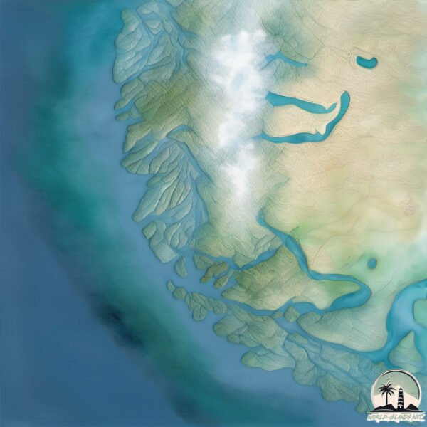
Geography and size of Larga
Size: 1.334 km²
Coastline: 9.2 km
Ocean: Pacific Ocean
Sea: South Pacific Ocean
Continent: South America
Larga is a Small Island spanning 1.3 km² with a coastline of 9.2 km.
Archipel: –
Tectonic Plate: Scotia – Situated in the Southern Ocean, surrounding the Scotia Sea, between South America and Antarctica, known for the Scotia Arc and active seismicity.
The geographic heart of the island is pinpointed at these coordinates:
Latitude: -54.25318822 / Longitude: -72.26992607
Climate and weather of Larga
Climate Zone: Polar
Climate Details: Tundra
Temperature: Cold
Climate Characteristics: The tundra climate features long, extremely cold winters and short, cool summers. Vegetation is limited to mosses, lichens, and small shrubs due to the low temperatures and short growing seasons. Biodiversity is low, but some specialized species thrive.
Topography and nature of Larga
Timezone: UTC-04:00
Timezone places: America/La_Paz
Max. Elevation: 18 m
Mean Elevation: 15 m
Vegetation: Shrubland
Tree Coverage: 65%
The mean elevation is 15 m. The highest elevation on the island reaches approximately 18 meters above sea level. The island is characterized by Plains: Flat, low-lying lands characterized by a maximum elevation of up to 200 meters. On islands, plains are typically coastal lowlands or central flat areas.
Dominating Vegetation: Shrubland
Dominated by shrubs and small bushes, these areas are typical in dry, rocky, or sandy environments, as well as in regions with poor soil fertility. Larga has a tree cover of 65 %.
Vegetation: 3 vegetation zones – Moderately Diverse Island
These islands start to show a broader range of ecological niches. With three vegetation zones, they may offer a mix of ecosystems like coastal areas, inland woods, and perhaps a distinct wetland or dry area. This diversity supports a wider range of flora and fauna, making these islands more ecologically complex than those with minimal diversity.
Infrastructure and Travelling to Larga
Does the island have a public airport? no.
There is no public and scheduled airport on Larga. The nearest airport is President Carlos Ibañez del Campo International Airport, located 208 km away.
Does the island have a major port? no.
There are no major ports on Larga. The closest major port is PORT SAN JUAN DE LA JUAN, approximately 164 km away.
The mean population of Larga is 7 per km². Larga is Gently Populated. The island belongs to Chile.
Continuing your journey, Mortimer is the next notable island, situated merely km away.
ISLAND ADVENTURE | LARVA | Cartoons for Kids | WildBrain Kids

Chile is classified as Emerging region: G20: Group of Twenty – Major economies comprising both developed and emerging countries, representing the world’s largest economies. The level of income is Upper middle income.
News – Latest Updates and Headlines from Larga
Stay informed with the most recent news and important headlines from Larga. Here’s a roundup of the latest developments.
Please note: The data used here has been primarily extracted from satellite readings. Deviations from exact values may occur, particularly regarding the height of elevations and population density. Land area and coastline measurements refer to average values at mean high tide.