Likuri Island
Welcome to Likuri Island, a Tropical island in the South Pacific Ocean, part of the majestic Pacific Ocean. This guide offers a comprehensive overview of what makes Likuri Island unique – from its geography and climate to its population, infrastructure, and beyond. Dive into the details:
- Geography and Size: Explore the island’s size and location.
- Climate and Weather: Weather patterns and temperature.
- Topography and Nature: Uncover the natural wonders of the island.
- Infrastructure and Travelling: Insights on reaching, staying, and making the most of your visit.
- News and Headlines: Latest News.
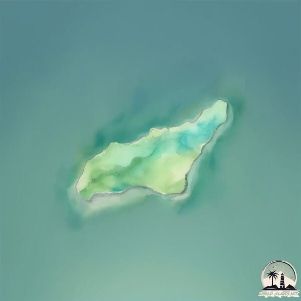
Geography and size of Likuri Island
Size: 0.115 km²
Coastline: 1.9 km
Ocean: Pacific Ocean
Sea: South Pacific Ocean
Continent: Oceania
Likuri Island is a Tiny Island spanning 0.115 km² with a coastline of 1.9 km.
Archipel: Fiji – Fiji, an archipelago in the South Pacific Ocean, is composed of more than 300 islands and is famed for its stunning coral reefs, beautiful tropical beaches, and rich cultural heritage. It’s a popular tourist destination, offering a range of activities from snorkeling to exploring traditional Fijian villages. Fiji’s diverse population has created a unique blend of indigenous, Indian, Chinese, and European cultures.
Tectonic Plate: Australia – A major tectonic plate covering Australia, New Zealand, and parts of the Indian and Pacific Oceans, known for its relative stability and occasional seismic activity.
The geographic heart of the island is pinpointed at these coordinates:
Latitude: -18.05591391 / Longitude: 177.28721904
Climate and weather of Likuri Island
Climate Zone: Tropical
Climate Details: Tropical Rainforest Climate
Temperature: Hot
Climate Characteristics: This climate is typified by heavy rainfall throughout the year, high humidity, and consistently high temperatures, leading to lush rainforests and rich biodiversity. Seasonal temperature variations are minimal.
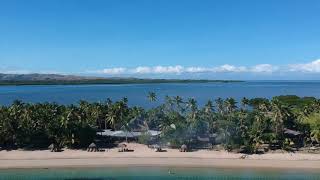
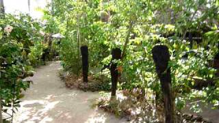
Topography and nature of Likuri Island
Timezone: UTC+12:00
Timezone places: Pacific/Auckland
Max. Elevation: -3 m
Mean Elevation: -3 m
Vegetation: Evergreen Needleleaf Forest
Tree Coverage: 86%
The mean elevation is -3 m. Remarkably, this unique island barely emerges above the sea level, showcasing nature’s fascinating interplay with the ocean. The island is characterized by Plains: Flat, low-lying lands characterized by a maximum elevation of up to 200 meters. On islands, plains are typically coastal lowlands or central flat areas.
Dominating Vegetation: Evergreen Needleleaf Forest
Dominated by evergreen coniferous trees such as pines and firs, which retain their needle-like leaves throughout the year. These forests are often found in cooler climates. Likuri Island has a tree cover of 86 %.
Vegetation: 1 vegetation zones – Minimal Diversity Island
These islands exhibit the most basic level of ecological diversity, often characterized by a single dominant vegetation type. This could be due to extreme environmental conditions, limited land area, or significant human impact. They represent unique ecosystems where specific species have adapted to thrive in these singular environments.
Infrastructure and Travelling to Likuri Island
Does the island have a public airport? no.
There is no public and scheduled airport on Likuri Island. The nearest airport is Malolo Lailai Island Airport, located 32 km away.
Does the island have a major port? no.
There are no major ports on Likuri Island. The closest major port is LAUTOKA HARBOR, approximately 53 km away.
The mean population of Likuri Island is 51 per km². Likuri Island is Gently Populated. The island belongs to Fiji.
Continuing your journey, Malolo Island is the next notable island, situated merely km away.
Likuri Island Resort Fiji | Fiji Accommodation


Fiji is classified as Developing region: Regions characterized by lower income levels, with economies in the process of industrialization and modernization. The level of income is Lower middle income.
News – Latest Updates and Headlines from Likuri Island
Stay informed with the most recent news and important headlines from Likuri Island. Here’s a roundup of the latest developments.
Please note: The data used here has been primarily extracted from satellite readings. Deviations from exact values may occur, particularly regarding the height of elevations and population density. Land area and coastline measurements refer to average values at mean high tide.