Lingshan Dao
Welcome to Lingshan Dao, a Continental island in the Yellow Sea, part of the majestic Pacific Ocean. This guide offers a comprehensive overview of what makes Lingshan Dao unique – from its geography and climate to its population, infrastructure, and beyond. Dive into the details:
- Geography and Size: Explore the island’s size and location.
- Climate and Weather: Weather patterns and temperature.
- Topography and Nature: Uncover the natural wonders of the island.
- Infrastructure and Travelling: Insights on reaching, staying, and making the most of your visit.
- News and Headlines: Latest News.
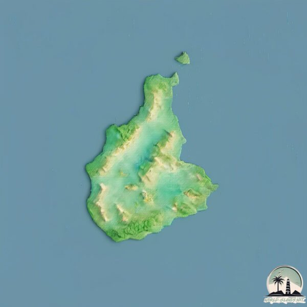
Geography and size of Lingshan Dao
Size: 7.61 km²
Coastline: 18.5 km
Ocean: Pacific Ocean
Sea: Yellow Sea
Continent: Asia
Lingshan Dao is a Small Island spanning 7.6 km² with a coastline of 18.5 km.
Archipel: –
Tectonic Plate: Amur – A minor tectonic plate in the region of the Amur River at the border of Russia and China, involved in complex interactions with the Pacific and Eurasian plates.
The geographic heart of the island is pinpointed at these coordinates:
Latitude: 35.76025581 / Longitude: 120.16793821
Climate and weather of Lingshan Dao
Climate Zone: Continental
Climate Details: Monsoon-Influenced Hot-Summer Humid Continental Climate
Temperature: Hot Summer
Climate Characteristics: Hot summers with monsoon rains, contrasting with dry, cold winters. Typical of east Asian continental edges.
Topography and nature of Lingshan Dao
Timezone: UTC+08:00
Timezone places: Australia/Perth
Max. Elevation: 294 m
Mean Elevation: 142 m
Vegetation: Open Woodland
Tree Coverage: 51%
The mean elevation is 142 m. The highest elevation on the island reaches approximately 294 meters above sea level. The island is characterized by Hills: Gently sloping landforms with rounded tops, having a maximum elevation between 200 and 500 meters. Hills contribute to a varied landscape on islands.
Dominating Vegetation: Open Woodland
Characterized by sparsely distributed trees with open canopy allowing sunlight to penetrate, supporting grasses and shrubs underneath. Often found in drier or transitional environments. Lingshan Dao has a tree cover of 51 %.
Vegetation: 9 vegetation zones – Very Highly Diverse Island
Islands in this range are ecological powerhouses, showcasing a wide array of vegetation zones. Each zone, from lush rainforests to arid scrublands, coastal mangroves to mountainous regions, contributes to a complex and interdependent ecosystem. These islands are often hotspots of biodiversity, supporting numerous species and intricate ecological processes.
Infrastructure and Travelling to Lingshan Dao
Does the island have a public airport? no.
There is no public and scheduled airport on Lingshan Dao. The nearest airport is Qingdao Jiaodong International Airport, located 65 km away.
Does the island have a major port? no.
There are no major ports on Lingshan Dao. The closest major port is QINGDAO GANG, approximately 29 km away.
The mean population of Lingshan Dao is 702 per km². Lingshan Dao is Densely Populated. The island belongs to China.
Continuing your journey, Nanchangshan Dao is the next notable island, situated merely km away.
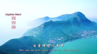
Scenery of Lingshan Island 灵山岛风光

China is classified as Emerging region: BRIC: Brazil, Russia, India, and China – Economies noted for their rapid growth and increasing influence on global affairs. The level of income is Upper middle income.
News – Latest Updates and Headlines from Lingshan Dao
Stay informed with the most recent news and important headlines from Lingshan Dao. Here’s a roundup of the latest developments.
Please note: The data used here has been primarily extracted from satellite readings. Deviations from exact values may occur, particularly regarding the height of elevations and population density. Land area and coastline measurements refer to average values at mean high tide.