Linqiangshi
Welcome to Linqiangshi, a Tropical island in the South China Sea, part of the majestic Pacific Ocean. This guide offers a comprehensive overview of what makes Linqiangshi unique – from its geography and climate to its population, infrastructure, and beyond. Dive into the details:
- Geography and Size: Explore the island’s size and location.
- Climate and Weather: Weather patterns and temperature.
- Topography and Nature: Uncover the natural wonders of the island.
- Infrastructure and Travelling: Insights on reaching, staying, and making the most of your visit.
- News and Headlines: Latest News.
Geography and size of Linqiangshi
Size: 1.002 km²
Coastline: 8.5 km
Ocean: Pacific Ocean
Sea: South China Sea
Continent: Asia
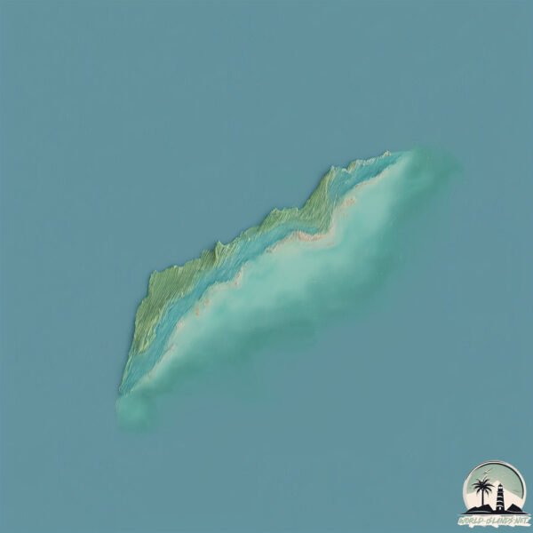
Linqiangshi is a Small Island spanning 1 km² with a coastline of 8.5 km.
Archipel: –
Tectonic Plate: Philippine Sea – An oceanic tectonic plate beneath the Philippine Sea, east of the Philippines. It’s involved in complex interactions with the surrounding Eurasian, Pacific, and Indo-Australian plates, leading to significant volcanic and seismic activity in the region.
The geographic heart of the island is pinpointed at these coordinates:
Latitude: 19.67929735 / Longitude: 109.09397833
Climate and weather of Linqiangshi
Climate Zone: Tropical
Climate Details: Tropical Monsoon Climate
Temperature: Hot
Climate Characteristics: Characterized by heavy rainfall, high humidity, and uniformly high temperatures, but with a distinct short dry season. It features a seasonal reversal of prevailing wind directions.
Topography and nature of Linqiangshi
Timezone: UTC+08:00
Timezone places: Australia/Perth
Max. Elevation: -2 m
Mean Elevation: -5 m
Vegetation: Evergreen Broadleaf Forest
Tree Coverage: 38%
The mean elevation is -5 m. Remarkably, this unique island barely emerges above the sea level, showcasing nature’s fascinating interplay with the ocean. The island is characterized by Plains: Flat, low-lying lands characterized by a maximum elevation of up to 200 meters. On islands, plains are typically coastal lowlands or central flat areas.
Dominating Vegetation: Evergreen Broadleaf Forest
Characterized by dense, lush canopies of broadleaf trees that retain their leaves year-round. These forests are typically found in tropical and subtropical regions and are known for their high biodiversity. Linqiangshi has a tree cover of 38 %.
Vegetation: 1 vegetation zones – Minimal Diversity Island
These islands exhibit the most basic level of ecological diversity, often characterized by a single dominant vegetation type. This could be due to extreme environmental conditions, limited land area, or significant human impact. They represent unique ecosystems where specific species have adapted to thrive in these singular environments.
Infrastructure and Travelling to Linqiangshi
Does the island have a public airport? no.
There is no public and scheduled airport on Linqiangshi. The nearest airport is Haikou Meilan International Airport, located 152 km away.
Does the island have a major port? no.
There are no major ports on Linqiangshi. The closest major port is YANGPU, approximately 9 km away.
The mean population of Linqiangshi is per km². Linqiangshi is . The island belongs to China.
Continuing your journey, Hainan is the next notable island, situated merely km away.
🏝️ Escape to Xiaoliuqiu: Taiwan’s Tropical Island Adventure! |📍𝑿𝒊𝒂𝒐𝒍𝒊𝒖𝒒𝒊𝒖|Whirlwind Trip


China is classified as Emerging region: BRIC: Brazil, Russia, India, and China – Economies noted for their rapid growth and increasing influence on global affairs. The level of income is Upper middle income.
News – Latest Updates and Headlines from Linqiangshi
Stay informed with the most recent news and important headlines from Linqiangshi. Here’s a roundup of the latest developments.
Please note: The data used here has been primarily extracted from satellite readings. Deviations from exact values may occur, particularly regarding the height of elevations and population density. Land area and coastline measurements refer to average values at mean high tide.