Welcome to Lisianski, a Tropical island in the North Pacific Ocean, part of the majestic Pacific Ocean. This guide offers a comprehensive overview of what makes Lisianski unique – from its geography and climate to its population, infrastructure, and beyond. Dive into the details:
Geography and size of Lisianski
Size: 1.3 km²
Coastline: 5 km
Ocean: Pacific Ocean
Sea: North Pacific Ocean
Continent: Oceania
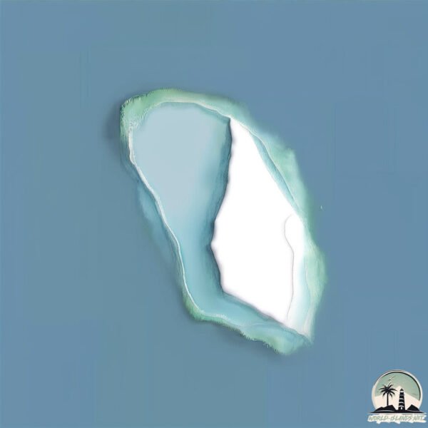
Lisianski is a Small Island spanning 1.3 km² with a coastline of 5 km.
Archipel: Hawaiian Islands – An archipelago in the central Pacific Ocean, known for their volcanic landscapes, rich Polynesian culture, and unique flora and fauna.
Tectonic Plate: North America – Covers North America and parts of the Atlantic and Arctic Oceans, characterized by diverse geological features and varying levels of seismic activity.
The geographic heart of the island is pinpointed at these coordinates:
Latitude: 26.06389371 / Longitude: -173.96598086
Climate and weather of Lisianski
Climate Zone: Tropical
Climate Details: Tropical Savanna, Wet
Temperature: Hot
Climate Characteristics: Defined by distinct wet and dry seasons with high temperatures year-round. Pronounced rainfall occurs during the wet season, while the dry season is marked by drought.
Topography and nature of Lisianski
Timezone: UTC-10:00
Timezone places: Pacific/Honolulu
Max. Elevation: 5 m
Mean Elevation: 3 m
Vegetation: Evergreen Needleleaf Forest
Tree Coverage: 67%
The mean elevation is 3 m. The highest elevation on the island reaches approximately 5 meters above sea level. The island is characterized by Plains: Flat, low-lying lands characterized by a maximum elevation of up to 200 meters. On islands, plains are typically coastal lowlands or central flat areas.
Dominating Vegetation: Evergreen Needleleaf Forest
Dominated by evergreen coniferous trees such as pines and firs, which retain their needle-like leaves throughout the year. These forests are often found in cooler climates. Lisianski has a tree cover of 67 %.
Vegetation: 4 vegetation zones – Diverse Island
Four distinct vegetation zones mark these islands as ecologically diverse. They might feature varied landscapes such as forests, beaches, grasslands, and rocky areas. Such diversity reflects the island’s complex ecological interactions and varied habitats, which can support a rich array of wildlife and plant species.
Infrastructure and Travelling to Lisianski
Does the island have a public airport? no.
There is no public and scheduled airport on Lisianski. The nearest airport is Lihue Airport, located 1687 km away.
Does the island have a major port? no.
There are no major ports on Lisianski. The closest major port is MIDWAY ISLAND, approximately 444 km away.
The mean population of Lisianski is 0 per km². Lisianski is Uninhabited. The island belongs to United States of America.
Continuing your journey, Niihau is the next notable island, situated merely km away.
Earth Space View: Lisianski Island (Northwestern Hawaiian Islands)
This view was captured from the live stream from the ISS that can be found here: https://afar.tv/iss/youtube1/ or ...Earth Space View: Lisianski Island (Northwestern Hawaiian Islands)
This view was captured from the live stream from the ISS that can be ...
Why You Can't Visit This Hawaiian Island 🤯
Why is there a Hawaiian island completely off-limits to tourists for ...
Why is there a Hawaiian island completely off-limits to tourists for over 150 years? What could be hidden there that you're not ...
This small island has the CRAZIEST story....
Could YOU survive 15 years shipwrecked here? Check out ...
Lisianski Island
Video Software we use:
https://amzn.to/2KpdCQF Ad-free videos. You can support us by purchasing something through our ...
This is the World's Most Remote Island..
The World's Most Remote Islands are the Pitcairn Islands located in ...
The World's Most Remote Islands are the Pitcairn Islands located in the south pacific ocean. The town here is known as ...
Hawaii's Forgotten Islands
The US State of Hawaii lies on an island chain in the tropical North ...
The US State of Hawaii lies on an island chain in the tropical North Pacific, and is the newest of the US's 50 states. But there's ...
Lisianski (Site 52), Northwest Hawaiian Islands 2016
This 3D model was collected on Lisianksi, part of the ...
This 3D model was collected on Lisianksi, part of the Papahānaumokuākea Marine National Monument, which was established in ...
Galapagos shark during deco at Lisianski video by Robert K Whitton
Laysan Kauo Island in Hawaiian Islands Group In Central Pacific Ocean Google Earth and Google Maps
Central Pacific Ocean Kauō-Laysan Island in Hawaiian Islands Group In ...
Central Pacific Ocean Kauō-Laysan Island in Hawaiian Islands Group In Google Earth and Google Maps.
Here’s Why This Forbidden Hawaiian Island Is Completely Off Limits To The Public
Here's Why This Forbidden Hawaiian Island Is Completely Off Limits To ...
Here's Why This Forbidden Hawaiian Island Is Completely Off Limits To The Public source story:
http://scribol.com Not forget to ...
The Hawaiian Islands are Further Apart Than You Think
Terrifying Islands That Actually Exist... #shorts #scary #island
Why Nobody Lives On These Hawaiian Islands.#hawaii #unitedstates #volcano
hawaii #hawaiianislands #volcano #pacificocean #tectonicplates ...
hawaii #hawaiianislands #volcano #pacificocean #tectonicplates #islandchain #usa #unitedstates #states #forbiddenisland ...
Agile in Lisianski Inlet
Video provided by the current owner of the Agile, the boat I grew up ...
Video provided by the current owner of the Agile, the boat I grew up with. Lisianski Inlet is where Pelican is located and was our ...
Approaching Lisianski Inlet USFS Float
Why Nobody Uses Boats Between the Hawaiian Islands
Have you ever wondered why people don't just take boats between the ...
Have you ever wondered why people don't just take boats between the Hawaiian Islands?Well, it turns out the ocean between ...
Day 19 Finding Islands No-One Knows!
Lisianski Island is a small, remote coral island located in the ...
Lisianski Island is a small, remote coral island located in the central Pacific Ocean, within the Hawaiian Island chain. It lies about ...
The First Hawaiians — How Polynesians Discovered Hawai‘i 🌊🇵🇼
Hawaii #NativeHawaiians #PolynesianHistory #AncientVoyagers ...
Hawaii #NativeHawaiians #PolynesianHistory #AncientVoyagers #PacificIslands #HistoryShorts #HawaiianCulture.
Investigating 13 Bizarre Islands
Geography More fun geography videos: 100 Extraordinary Geography ...
Hawaii’s Hidden Islands That Will Blow Your Mind
Discover Hawaii Like Never Before! Most people think Hawaii is just a ...
Discover Hawaii Like Never Before! Most people think Hawaii is just a few tropical islands—but the truth is far more incredible.
2019 Bohemia Creek in Lisianski Strait
Coast Guard MH-60T Jayhawk aircrew rescue 3 fishermen near Lisianski Strait
A U.S. Coast Guard MH-60T Jayhawk helicopter aircrew rescuing three ...
A U.S. Coast Guard MH-60T Jayhawk helicopter aircrew rescuing three people, July 4, 2022. Watchstanders in the U.S. Coast ...
Why aren't there any brigdes connecting the Hawaiian Islands? #geography #map #facts
New Hawaii Tour Begins Today! | Sand, Midway, Pearl and Hermes Atoll, Lisianski, Laysan Islands
Broadcasted live on Twitch -- Watch live at ...
We Explored an ABANDONED ISLAND in the Pacific (Rongelap Atoll) [Ep. 187]
An entire island abandoned — not by war or disaster, but by something ...
An entire island abandoned — not by war or disaster, but by something invisible. Rongelap Atoll was once a thriving Pacific ...
United States of America is classified as Developed region: G7: Group of Seven – Major advanced economies, including Canada, France, Germany, Italy, Japan, the United Kingdom, and the United States. The level of income is High income: OECD.
News – Latest Updates and Headlines from Lisianski
Stay informed with the most recent news and important headlines from Lisianski. Here’s a roundup of the latest developments.
Loading...
Please note: The data used here has been primarily extracted from satellite readings. Deviations from exact values may occur, particularly regarding the height of elevations and population density. Land area and coastline measurements refer to average values at mean high tide.


![We Explored an ABANDONED ISLAND in the Pacific (Rongelap Atoll) [Ep. 187]](https://i.ytimg.com/vi/3kjyB0gEiK0/mqdefault.jpg)