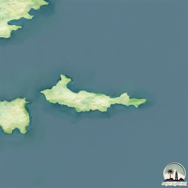
Welcome to Little Kiska, a Polar island in the Bering Sea, part of the majestic Pacific Ocean. This guide offers a comprehensive overview of what makes Little Kiska unique – from its geography and climate to its population, infrastructure, and beyond. Dive into the details:
Geography and size of Little Kiska
Size: 7.407 km²
Coastline: 27.3 km
Ocean: Pacific Ocean
Sea: Bering Sea
Continent: North America
Little Kiska is a Small Island spanning 7.4 km² with a coastline of 27.3 km.
Archipel: Aleutian Islands – A chain of islands stretching from Alaska to Russia, known for their rugged beauty, abundant wildlife, and volcanic activity.
Tectonic Plate: Amur – A minor tectonic plate in the region of the Amur River at the border of Russia and China, involved in complex interactions with the Pacific and Eurasian plates.
The geographic heart of the island is pinpointed at these coordinates:
Latitude: 51.95244538 / Longitude: 177.65511167
Climate and weather of Little Kiska
Climate Zone: Polar
Climate Details: Tundra
Temperature: Cold
Climate Characteristics: The tundra climate features long, extremely cold winters and short, cool summers. Vegetation is limited to mosses, lichens, and small shrubs due to the low temperatures and short growing seasons. Biodiversity is low, but some specialized species thrive.
Topography and nature of Little Kiska
Timezone: UTC-10:00
Timezone places:
Max. Elevation: 97 m
Mean Elevation: 61 m
Vegetation: Herbaceous Cover
Tree Coverage: 64%
The mean elevation is 61 m. The highest elevation on the island reaches approximately 97 meters above sea level. The island is characterized by Plains: Flat, low-lying lands characterized by a maximum elevation of up to 200 meters. On islands, plains are typically coastal lowlands or central flat areas.
Dominating Vegetation: Herbaceous Cover
Comprising mainly of grasses, herbs, and ferns, these areas are common in prairies, meadows, and savannas, and can vary widely in species composition. Little Kiska has a tree cover of 64 %.
Vegetation: 7 vegetation zones – Very Highly Diverse Island
Islands in this range are ecological powerhouses, showcasing a wide array of vegetation zones. Each zone, from lush rainforests to arid scrublands, coastal mangroves to mountainous regions, contributes to a complex and interdependent ecosystem. These islands are often hotspots of biodiversity, supporting numerous species and intricate ecological processes.
Infrastructure and Travelling to Little Kiska
Does the island have a public airport? no.
There is no public and scheduled airport on Little Kiska. The nearest airport is Ugolny Yuri Ryktheu Airport, located 1418 km away.
Does the island have a major port? no.
There are no major ports on Little Kiska. The closest major port is KISKA, approximately 8 km away.
The mean population of Little Kiska is 0 per km². Little Kiska is Uninhabited. The island belongs to United States of America.
Continuing your journey, Kiska is the next notable island, situated merely km away.
Exploring Kiska Island: Alaska's Hidden Gem
Join us on an unforgettable journey as we explore Kiska Island, one of Alaska's hidden gems! In this travel vlog, we dive into the ...Exploring Kiska Island: Alaska's Hidden Gem
Join us on an unforgettable journey as we explore Kiska Island, one of ...
Join us on an unforgettable journey as we explore Kiska Island, one of Alaska's hidden gems! In this travel vlog, we dive into the ...
Kiska History
In June of 1942, over 5000 Japanese soldiers landed on Kiska Island ...
In June of 1942, over 5000 Japanese soldiers landed on Kiska Island and took control of American soil. Mountain Troops of the ...
Dragon Rising (Little Kiska Island)
Destroyed Japanese zero planes at Kiska Island Kiska in Aleutian Island, Alaska HD Stock Footage
CriticalPast is an archive of historic footage. The vintage footage in ...
CriticalPast is an archive of historic footage. The vintage footage in this video has been uploaded for research purposes, and is ...
Battle of Kiska — How One Tiny Island Changed World War II Forever
Battle of Kiska — How the Battle Changed WWII In the fall of 1942, a ...
Battle of Kiska — How the Battle Changed WWII In the fall of 1942, a seemingly minor battle on a desolate island in the Aleutian ...
Exploring the Enigmatic Kiska Island
This script explores Kiska Island in the Aleutian chain, renowned for ...
This script explores Kiska Island in the Aleutian chain, renowned for its wildlife and World War II history. #KiskaIsland #Alaska ...
Discover Kiska Island A Hidden Gem!
Kiska Island during the Aleutian campaign, WWII, 1943
Kiska Island during the Aleutian campaign, WWII, 1943.
Kiska Island during the Aleutian campaign, WWII, 1943.
The Battle of Kiska: The Island with No Enemies #battle #kiska #island #ww2 #history #army #military
Discover the bizarre WWII battle where US Forces encountered... no ...
Discover the bizarre WWII battle where US Forces encountered... no enemies! History can be unexpectedly funny. #History #WWII ...
The Strange Invasion of Kiska
Kiska Island A Chilling History of WWII and Hidden Dangers #history #facts #historyfacts
Kiska Island 1943: They Fought Ghosts in the Fog (Aleutian Campaign)
In 1943, tens of thousands of Allied troops stormed Kiska Island in ...
In 1943, tens of thousands of Allied troops stormed Kiska Island in Alaska, expecting a brutal fight during the Aleutian Campaign ...
A Place Where Time Stands Still: Aleutian Islands
Thank you so much for joining me on this adventure. Please don't ...
Thank you so much for joining me on this adventure. Please don't forget to like this video, and subscribe to my YouTube channel, ...
What Happened at Kiska Island in 1943?
Kiska Alaska.
Kiska Alaska.
Allied troops invade Kiska island in the Aleutians
August 15, 1943: Over 34000 American and Canadian troops land on Kiska ...
August 15, 1943: Over 34000 American and Canadian troops land on Kiska island to find that the Japanese have fled. This clip is ...
NPC-10189 Kiska, Aleutian Islands, Alaska: 09/1943 (full)
Naval Photographic Center film #10189. Freely downloadable at the ...
Naval Photographic Center film #10189. Freely downloadable at the Internet Archive, where I first uploaded it. National Archives ...
THE MOST RIDICULOUS BATTLE OF WORLD WAR 2 ( KISKA ISLAND )#KISKA_ISLAND #history #worldwar2
Kiska And Attu In The Aleutians (1943)
Full title reads: "KISKA AND ATTU IN THE ALEUTIANS". Kiska & Attu, ...
Full title reads: "KISKA AND ATTU IN THE ALEUTIANS". Kiska & Attu, Aleutians. Various shots of the men clearing snow in ...
The Battle of Kiska, 1943: An Unopposed Combat
Dive into the peculiar Battle of Kiska during WWII, where U.S. and ...
Dive into the peculiar Battle of Kiska during WWII, where U.S. and Canadian forces landed ready to fight, only to find the Japanese ...
How Allies Took Kiska Island! WWII 🇺🇸🇨🇦
Discover how Allied forces reclaimed Kiska Island! Witness the pivotal ...
Discover how Allied forces reclaimed Kiska Island! Witness the pivotal August 15, 1943 operation as U.S. and Canadian ...
Decision 16 | Kiska island withdrawal operation(1943)
I am not the copyright owner of this video. This video is allowed to ...
I am not the copyright owner of this video. This video is allowed to be reused by Content ID. All revenue from the ads shown in this ...
WWII’s Strangest Invasion: The Empty Island of Kiska
August 1943: Thousands of Allied troops invaded Kiska Island to oust ...
August 1943: Thousands of Allied troops invaded Kiska Island to oust Japanese forces—only to find it completely abandoned.
Landing Operations at Kiska Island, Alaska (1943) | WW2
Shot List: 1) MS Port side of battleship. 2) MS OS2U coming in for ...
Shot List: 1) MS Port side of battleship. 2) MS OS2U coming in for landing in slick made from BB; it taxies up and hooks onto net, ...
Destroyed Japanese submarine base at Kiska Island Kiska in Aleutian Island, Alask...HD Stock Footage
CriticalPast is an archive of historic footage. The vintage footage in ...
CriticalPast is an archive of historic footage. The vintage footage in this video has been uploaded for research purposes, and is ...
Least & Crested Auklets - Kiska Island
Kiska Island in the western Aleutian Islands of Alaska is home to more ...
Kiska Island in the western Aleutian Islands of Alaska is home to more than 1.5 million auklets, and each night, they return to the ...
United States of America is classified as Developed region: G7: Group of Seven – Major advanced economies, including Canada, France, Germany, Italy, Japan, the United Kingdom, and the United States. The level of income is High income: OECD.
News – Latest Updates and Headlines from Little Kiska
Stay informed with the most recent news and important headlines from Little Kiska. Here’s a roundup of the latest developments.
Loading...
Please note: The data used here has been primarily extracted from satellite readings. Deviations from exact values may occur, particularly regarding the height of elevations and population density. Land area and coastline measurements refer to average values at mean high tide.