Welcome to Long Island, a Temperate island in the Tasman Sea, part of the majestic Pacific Ocean. This guide offers a comprehensive overview of what makes Long Island unique – from its geography and climate to its population, infrastructure, and beyond. Dive into the details:
Geography and size of Long Island
Size: 1.054 km²
Coastline: 5.4 km
Ocean: Pacific Ocean
Sea: Tasman Sea
Continent: Oceania
Long Island is a Small Island spanning 1.1 km² with a coastline of 5.4 km.
Archipel: –
Tectonic Plate: Australia – A major tectonic plate covering Australia, New Zealand, and parts of the Indian and Pacific Oceans, known for its relative stability and occasional seismic activity.
The geographic heart of the island is pinpointed at these coordinates:
Latitude: -30.18029418 / Longitude: 147.97591118
Climate and weather of Long Island
Climate Zone: Temperate
Climate Details: Humid Subtropical Climate
Temperature: Hot Summer
Climate Characteristics: With continuous rainfall and hot summers, this climate is common in some coastal regions, supporting diverse vegetation.
Topography and nature of Long Island
Timezone: UTC+10:00
Timezone places: Australia/Sydney
Max. Elevation: 6 m
Mean Elevation: 2 m
Vegetation: Mangrove Forest
Tree Coverage: 95%
The mean elevation is 2 m. The highest elevation on the island reaches approximately 6 meters above sea level. The island is characterized by Plains: Flat, low-lying lands characterized by a maximum elevation of up to 200 meters. On islands, plains are typically coastal lowlands or central flat areas.
Dominating Vegetation: Mangrove Forest
Found in coastal areas and river deltas, these unique wetland ecosystems are adapted to saline conditions and are crucial for coastal protection and biodiversity. Long Island has a tree cover of 95 %.
Vegetation: 5 vegetation zones – Highly Diverse Island
With five different vegetation zones, these islands offer a rich tapestry of ecosystems. The variety could include dense forests, open meadows, wetlands, coastal zones, and more. This level of diversity supports an intricate web of life, with each zone playing a vital role in the overall ecological health and balance of the island.
Infrastructure and Travelling to Long Island
Does the island have a public airport? no.
There is no public and scheduled airport on Long Island. The nearest airport is Sunshine Coast Airport, located 37 km away.
Does the island have a major port? no.
There are no major ports on Long Island. The closest major port is WELSHPOOL, approximately 25 km away.
The mean population of Long Island is 19 per km². Long Island is Gently Populated. The island belongs to Australia.
Continuing your journey, Sand is the next notable island, situated merely km away.
Long Island (Extended)
Provided to YouTube by Foundation Media LLC Long Island (Extended) · Public Works Pocket Knife ℗ 2025 Public Works ...Long Island (Extended)
Provided to YouTube by Foundation Media LLC Long Island (Extended) · ...
Provided to YouTube by Foundation Media LLC Long Island (Extended) · Public Works Pocket Knife ℗ 2025 Public Works ...
Long Island Explained In 3 Minutes.
In The Northeastern Part Of United States, On The Southern Coast Of ...
In The Northeastern Part Of United States, On The Southern Coast Of New York State, Lies The Long Island, The Largest Island In ...
Why Long Island Wants to Become the 51st State ?
shorts #geoshorts #longisland #newyork #nyc #america #usa #facts ...
shorts #geoshorts #longisland #newyork #nyc #america #usa #facts #geography #geographythroughmaps #geographyfacts.
Public Works - Long Island (Official Visualizer)
Official visualizer for "Long Island" by Public Works.
Official visualizer for "Long Island" by Public Works.
The Midnight - 'Long Island' (Official Audio)
The Midnight – Syndicate, out now ...
Zach Bryan - Jake's Piano - Long Island
Jake's Piano I finally quit smoking cigarettes And I don't go downtown ...
Jake's Piano I finally quit smoking cigarettes And I don't go downtown drinking till it's dawn The best parts of you are here but ...
Long Island
Provided to YouTube by Foundation Media LLC Long Island · Public Works ...
Provided to YouTube by Foundation Media LLC Long Island · Public Works Long Island ℗ 2024 Public Works exclusively ...
Long Island
Provided to YouTube by CDBaby Long Island · Prince Bulo Good Vibes ℗ ...
Provided to YouTube by CDBaby Long Island · Prince Bulo Good Vibes ℗ 2019 Prince Bulo Released on: 2019-08-02 ...
LONG ISLAND - fragile (Music Video)
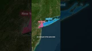
Long Island vs New York City. What’s the Real Difference? 🤯
This question confuses millions- even many Americans aren't sure where ...
This question confuses millions- even many Americans aren't sure where Long Island ends and New York City begins. Some ...
Madison Beer's Long Island Accent
Madison Beer takes the WIRED Autocomplete Interview and answers the ...
Madison Beer takes the WIRED Autocomplete Interview and answers the internet's most searched questions about herself.
Prince Bulo - Long Island (Official Music Video)
Subscribe to Prince Bulo's YouTube channel. ...
Long Island Vacation Travel Guide | Expedia
Long Island – Less than an hour's drive from NYC, find the first of ...
Long Island – Less than an hour's drive from NYC, find the first of the island's much-loved beaches. From there, follow us through ...
ICE activity on Long Island is spiking, activist says | News 12
An immigrant activist says ICE activity on Long Island has been ...
An immigrant activist says ICE activity on Long Island has been documented every day so far in November. Ahmad Perez, the ...
Long Island Iced Tea! 🍹 #longisland #longislandicedtea #cocktailsrecipe #cheers #cocktail
Long Island Highlights: Top Attractions & Places to Visit (New York)
This Long Island travel guide shares the best things to do in Long ...
This Long Island travel guide shares the best things to do in Long Island. -------------- How to travel more and visit your dream ...
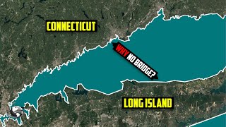
The Bridge That Could Change Long Island Forever — But Never Gets Built
The Bridge That Could Change Long Island Forever (But Never Gets ...
The Bridge That Could Change Long Island Forever (But Never Gets Built) Every day, Long Islanders face one of the worst ...
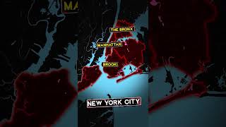
What is the Difference Between New York City, Long Island, and Manhattan? #newyork #geography #usa
history #conflict #demographics #map #coutry #countrys #power #us ...
history #conflict #demographics #map #coutry #countrys #power #us #america #manhattan #city #newjersey #unitedstates.
Everything I ate my first time on Long Island! #foodie #shorts #eating #nyc #longisland
The 4 Long Island Ice Tea Variations #cocktails #longislandicedtea #bartending #bartender
A Long Island Song (Official Music Video)
I grew up in Hauppauge and then started my family in East Islip. This ...
I grew up in Hauppauge and then started my family in East Islip. This is my song about the Long Island I remember.
Long Island Ice Tea
Provided to YouTube by recordJet Long Island Ice Tea · Jonesmann S.J. ...
Provided to YouTube by recordJet Long Island Ice Tea · Jonesmann S.J. ℗ 2023 Jonesmann Released on: 2006-01-27 ...
Sandbar shark wrangling jones beach long island #sharkfishing #shark #longisland
Locals Guide to the Best of Long Island, New York
Discover the best of Long Island in our full day exploring the Gold ...
Discover the best of Long Island in our full day exploring the Gold Coast. From charming seaside towns to hidden gems, this video ...
Jack Sparrow (feat. Michael Bolton)
Australia is classified as Developed region: nonG7: Developed economies outside of the Group of Seven, characterized by high income and advanced economic structures. The level of income is High income: OECD.
News – Latest Updates and Headlines from Long Island
Stay informed with the most recent news and important headlines from Long Island. Here’s a roundup of the latest developments.
Loading...
Please note: The data used here has been primarily extracted from satellite readings. Deviations from exact values may occur, particularly regarding the height of elevations and population density. Land area and coastline measurements refer to average values at mean high tide.