Lothian Island
Welcome to Lothian Island, a Tropical island in the Bay of Bengal, part of the majestic Indian Ocean. This guide offers a comprehensive overview of what makes Lothian Island unique – from its geography and climate to its population, infrastructure, and beyond. Dive into the details:
- Geography and Size: Explore the island’s size and location.
- Climate and Weather: Weather patterns and temperature.
- Topography and Nature: Uncover the natural wonders of the island.
- Infrastructure and Travelling: Insights on reaching, staying, and making the most of your visit.
- News and Headlines: Latest News.
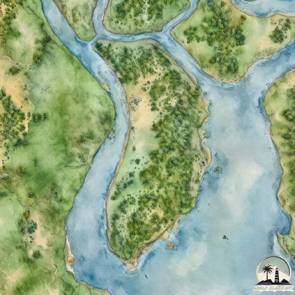
Geography and size of Lothian Island
Size: 36.2 km²
Coastline: 34.2 km
Ocean: Indian Ocean
Sea: Bay of Bengal
Continent: Asia
Lothian Island is a Medium Island spanning 36 km² with a coastline of 34 km.
Archipel: –
Tectonic Plate: India – A major tectonic plate that initially moved northward at a rapid pace before colliding with the Eurasian Plate. This collision is responsible for the uplift of the Himalayas and the Tibetan Plateau.
The geographic heart of the island is pinpointed at these coordinates:
Latitude: 21.65858745 / Longitude: 88.32708664
Climate and weather of Lothian Island
Climate Zone: Tropical
Climate Details: Tropical Savanna, Wet
Temperature: Hot
Climate Characteristics: Defined by distinct wet and dry seasons with high temperatures year-round. Pronounced rainfall occurs during the wet season, while the dry season is marked by drought.
Topography and nature of Lothian Island
Timezone: UTC+05:30
Timezone places: Asia/Kolkata
Max. Elevation: 6 m
Mean Elevation: 4 m
Vegetation: Mangrove Forest
Tree Coverage: 56%
The mean elevation is 4 m. The highest elevation on the island reaches approximately 6 meters above sea level. The island is characterized by Plains: Flat, low-lying lands characterized by a maximum elevation of up to 200 meters. On islands, plains are typically coastal lowlands or central flat areas.
Dominating Vegetation: Mangrove Forest
Found in coastal areas and river deltas, these unique wetland ecosystems are adapted to saline conditions and are crucial for coastal protection and biodiversity. Lothian Island has a tree cover of 56 %.
Vegetation: 13 vegetation zones – Exceptionally Diverse Island
Islands with more than ten vegetation zones are among the most ecologically rich and varied in the world. These islands are akin to miniature continents, boasting an incredible array of ecosystems. The sheer range of habitats, from high peaks to deep valleys, rainforests to deserts, creates a mosaic of life that is unparalleled. They are crucial for conservation and ecological studies.
Infrastructure and Travelling to Lothian Island
Does the island have a public airport? no.
There is no public and scheduled airport on Lothian Island. The nearest airport is Netaji Subhash Chandra Bose International Airport, located 106 km away.
Does the island have a major port? no.
There are no major ports on Lothian Island. The closest major port is HALDIA PORT, approximately 42 km away.
The mean population of Lothian Island is 1052 per km². Lothian Island is Densely Populated. The island belongs to India.
Continuing your journey, Rākshaskhāli is the next notable island, situated merely km away.
Lothian Island Wildlife Sanctuary, West Bengal


India is classified as Emerging region: BRIC: Brazil, Russia, India, and China – Economies noted for their rapid growth and increasing influence on global affairs. The level of income is Lower middle income.
News – Latest Updates and Headlines from Lothian Island
Stay informed with the most recent news and important headlines from Lothian Island. Here’s a roundup of the latest developments.
Please note: The data used here has been primarily extracted from satellite readings. Deviations from exact values may occur, particularly regarding the height of elevations and population density. Land area and coastline measurements refer to average values at mean high tide.