Low Island
Welcome to Low Island, a Dry island in the Red Sea, part of the majestic Indian Ocean. This guide offers a comprehensive overview of what makes Low Island unique – from its geography and climate to its population, infrastructure, and beyond. Dive into the details:
- Geography and Size: Explore the island’s size and location.
- Climate and Weather: Weather patterns and temperature.
- Topography and Nature: Uncover the natural wonders of the island.
- Infrastructure and Travelling: Insights on reaching, staying, and making the most of your visit.
- News and Headlines: Latest News.
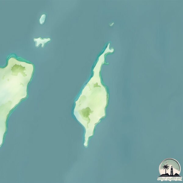
Geography and size of Low Island
Size: 0.433 km²
Coastline: 3.9 km
Ocean: Indian Ocean
Sea: Red Sea
Continent: Africa
Low Island is a Tiny Island spanning 0.433 km² with a coastline of 3.9 km.
Archipel: –
Tectonic Plate: Arabia – A major tectonic plate covering the Arabian Peninsula and parts of the Middle East. The plate is primarily continental and known for its collision with the Eurasian Plate, leading to the uplift of the Zagros Mountains.
The geographic heart of the island is pinpointed at these coordinates:
Latitude: 13.87280476 / Longitude: 42.82016424
Climate and weather of Low Island
Climate Zone: Dry
Climate Details: Hot Deserts Climate
Temperature: Hot
Climate Characteristics: Dominated by extremely hot temperatures, this climate is marked by minimal rainfall and barren landscapes. Nights often experience drastic temperature drops.
Topography and nature of Low Island
Timezone: UTC+03:00
Timezone places: Asia/Riyadh
Max. Elevation: 0 m
Mean Elevation: -1 m
Vegetation: Shrubland
Tree Coverage: 21%
The mean elevation is -1 m. The highest elevation on the island reaches approximately 0 meters above sea level. The island is characterized by Plains: Flat, low-lying lands characterized by a maximum elevation of up to 200 meters. On islands, plains are typically coastal lowlands or central flat areas.
Dominating Vegetation: Shrubland
Dominated by shrubs and small bushes, these areas are typical in dry, rocky, or sandy environments, as well as in regions with poor soil fertility. Low Island has a tree cover of 21 %.
Vegetation: 3 vegetation zones – Moderately Diverse Island
These islands start to show a broader range of ecological niches. With three vegetation zones, they may offer a mix of ecosystems like coastal areas, inland woods, and perhaps a distinct wetland or dry area. This diversity supports a wider range of flora and fauna, making these islands more ecologically complex than those with minimal diversity.
Infrastructure and Travelling to Low Island
Does the island have a public airport? no.
There is no public and scheduled airport on Low Island. The nearest airport is Assab International Airport, located 90 km away.
Does the island have a major port? no.
There are no major ports on Low Island. The closest major port is AL MUKHA, approximately 78 km away.
The mean population of Low Island is 128 per km². Low Island is Moderately Inhabited. The island belongs to Yemen.
Continuing your journey, Jazīrat Jabal Zuqar is the next notable island, situated merely km away.
LOW ISLAND // Don't Let The Light In (Live from the Stone Room)


![[Pause]](https://i.ytimg.com/vi/n2AVyg3I4Mw/mqdefault.jpg)


![LOW ISLAND // Momentary [Live and Stripped Back]](https://i.ytimg.com/vi/WuYD8rxw9uw/mqdefault.jpg)

Yemen is classified as Least developed region: Countries that exhibit the lowest indicators of socioeconomic development, with the lowest Human Development Index ratings. The level of income is Lower middle income.
News – Latest Updates and Headlines from Low Island
Stay informed with the most recent news and important headlines from Low Island. Here’s a roundup of the latest developments.
Please note: The data used here has been primarily extracted from satellite readings. Deviations from exact values may occur, particularly regarding the height of elevations and population density. Land area and coastline measurements refer to average values at mean high tide.