Luzon
Welcome to Luzon, a Tropical island in the Philippine Sea, part of the majestic Pacific Ocean. This guide offers a comprehensive overview of what makes Luzon unique – from its geography and climate to its population, infrastructure, and beyond. Dive into the details:
- Geography and Size: Explore the island’s size and location.
- Climate and Weather: Weather patterns and temperature.
- Topography and Nature: Uncover the natural wonders of the island.
- Infrastructure and Travelling: Insights on reaching, staying, and making the most of your visit.
- News and Headlines: Latest News.
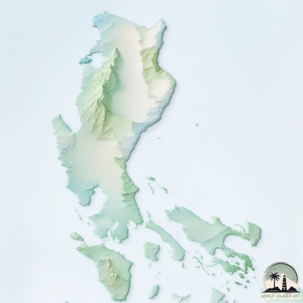
Geography and size of Luzon
Size: 104835 km²
Coastline: 7887 km
Ocean: Pacific Ocean
Sea: Philippine Sea
Continent: Asia
Luzon is a Colossal Island spanning 104835 km² with a coastline of 7887 km.
Archipel: Malay Archipelago – The world’s largest archipelago, located between mainland Southeast Asia and Australia, known for its immense biodiversity and cultural diversity.
Tectonic Plate: Philippine Sea – An oceanic tectonic plate beneath the Philippine Sea, east of the Philippines. It’s involved in complex interactions with the surrounding Eurasian, Pacific, and Indo-Australian plates, leading to significant volcanic and seismic activity in the region.
The geographic heart of the island is pinpointed at these coordinates:
Latitude: 15.95238608 / Longitude: 121.42427075
Climate and weather of Luzon
Climate Zone: Tropical
Climate Details: Tropical Monsoon Climate
Temperature: Hot
Climate Characteristics: Characterized by heavy rainfall, high humidity, and uniformly high temperatures, but with a distinct short dry season. It features a seasonal reversal of prevailing wind directions.
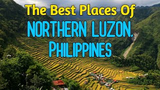
Topography and nature of Luzon
Timezone: UTC+08:00
Timezone places: Australia/Perth
Max. Elevation: 2922 m Mt. Pulog
Mean Elevation: 358 m
Vegetation: Evergreen Broadleaf Forest
Tree Coverage: 47%
The mean elevation is 358 m. Dominating the island’s landscape, the majestic “Mt. Pulog” rises as the highest peak, soaring to impressive heights. The island is characterized by Mountains: High, steeply elevated landforms. Characterized by both a high maximum elevation (over 500 meters) and a high mean elevation, creating rugged, mountainous terrains on islands.
Dominating Vegetation: Evergreen Broadleaf Forest
Characterized by dense, lush canopies of broadleaf trees that retain their leaves year-round. These forests are typically found in tropical and subtropical regions and are known for their high biodiversity. Luzon has a tree cover of 47 %.
Vegetation: 16 vegetation zones – Exceptionally Diverse Island
Islands with more than ten vegetation zones are among the most ecologically rich and varied in the world. These islands are akin to miniature continents, boasting an incredible array of ecosystems. The sheer range of habitats, from high peaks to deep valleys, rainforests to deserts, creates a mosaic of life that is unparalleled. They are crucial for conservation and ecological studies.
Infrastructure and Travelling to Luzon
Does the island have a public airport? yes.
Luzon has a public and scheduled airport. The following airports are located on this island: Bicol International Airport, Cagayan North International Airport, Air Juan Seaplane Base, Subic Bay International Airport / Naval Air Station Cubi Point, Clark International Airport / Clark Air Base, Laoag International Airport, Ninoy Aquino International Airport, Palanan Community Airport, Loakan Airport, Naga Airport, Dr Juan C Angara Airport, San Fernando Airport, Tuguegarao Airport, Cauayan Airport.
Does the island have a major port? yes.
Luzon is home to a major port. The following ports are situated on the island: SORSOGON, BATANGAS CITY, MARIVELES, MASINLOC, SAN FERNANDO HARBOR, HONDAGUA, LEGAZPI PORT, SUBIC BAY.
The mean population of Luzon is 553 per km². Luzon is Densely Populated. The island belongs to Philippines.
The name of the island resonates across different cultures and languages. Here is how it is known around the world: Arabic: لوزون; German: Luzon; Spanish: Luzón; French: Luçon; Portuguese: Lução; Russian: Лусон; Chinese: 呂宋
Continuing your journey, Santiago is the next notable island, situated merely km away.
Luzon Island | Philippines | The Destination


Philippines is classified as Emerging region: G20: Group of Twenty – Major economies comprising both developed and emerging countries, representing the world’s largest economies. The level of income is Lower middle income.
News – Latest Updates and Headlines from Luzon
Stay informed with the most recent news and important headlines from Luzon. Here’s a roundup of the latest developments.
Social Media Posts about Luzon
Please note: The data used here has been primarily extracted from satellite readings. Deviations from exact values may occur, particularly regarding the height of elevations and population density. Land area and coastline measurements refer to average values at mean high tide.